Snownut
Member
I wouldn't be a bit surprised if the sref goes back up today. I still think upstate could see an inch out of thisYeh SREF just went down for my area.
Sent from my SM-G955U using Tapatalk
I wouldn't be a bit surprised if the sref goes back up today. I still think upstate could see an inch out of thisYeh SREF just went down for my area.
Ummm a winter weather advisory is an upgrade from a winter storm watch...
Sent from my SM-G955U using Tapatalk
Thats it the party is over.
Sent from my SM-J320VPP using Tapatalk

Good thing I went ahead and started up that cliff...wont have to wait in line to jump...smdh.
Sent from my SM-J320VPP using Tapatalk
He isnt saying no snowGood thing I went ahead and started up that cliff...wont have to wait in line to jump...smdh
yeah I know...but anyone that's telling you they wouldn't rather see a good 3" snow than a dusting is lying to you. Gotta be honest ya know.He isnt saying no snow
Sent from my SM-J320VPP using Tapatalk
Knowing that he is usually the first to hype things up for HSV...this is very discouraging for those wanting meaningful snow in his market. However, this was never going to amount to much anyway....still time though..
Sent from my SM-J320VPP using Tapatalk

looked better than last run, it wasn't fizzling at allat 29 hours precip looks to be fizzling. Hopefully it fills back in over the next few frames.

I'll take a inch..NWS Nashville doesn't really forecast much at all
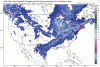
How did it look farther east?Thru 34, NAM looks solid for snow along I-59 through AL for you folks.
Grantham again with another great disco!Grantham has great disco this morning for kbmx:
"Some euro ensemble members, the 12km
NAM, and the Regional Canadian model are beginning to pick up the idea of an enhanced snow band across Central and East Alabama."
"With saturated profiles and efficient snow ratios of 15:1, snowfall amounts could
easily be underdone if models are underplaying the amount of lift."

Yeah it does well once it gets into VirginiaIMO it's evident we are getting a lot of help from the gulf. Just looking at surface maps precip goes poof once it crosses the mountains But the flow out of the gulf remains and should get some enhancement once it gets on the backside
How did it look farther east?


Vorticity stretching in the wake of the Apps plus stout southwesterly moisture advection off the Gulf helps a lot... W/o continued vorticity stretching the precipitation shield may weaken a little some as it comes east into the eastern piedmont and/or west-central coastal plainNam just went boom over upstate SC. Now that's some Leeside enhancement. This is our only shot
Lake Lanier snow shield! Lol. Almost all guidance has it too.How is this even possible. Looks like a few others and I are screwed if it verifies.
Temps, temps, temps! If this comes in Tuesday evening or even midnight , I promise you upstate will be at 45+ degrees when rain startsNam just went boom over upstate SC. Now that's some Leeside enhancement. This is our only shot
I don't even think Delta, 1300, or Webber have an answer for why that could happen. It's just weird. I fear it to be true though.Lake Lanier snow shield! Lol. Almost all guidance has it too.