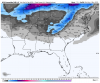
In the history of clippers, 2 inches is the max ever for CHA, down in the valley. As per Neal Pascal, old and disgraced former tv met in our region. I miss his weirdness. He was always going out on a limb with his forecasts while all the other local tv mets stuck to NWS dictum.GFS gets clipper snow on a line from Jackson TN to Birmingham AL at 00z..then down into Carrollton GA
-
Hello, please take a minute to check out our awesome content, contributed by the wonderful members of our community. We hope you'll add your own thoughts and opinions by making a free account!
You are using an out of date browser. It may not display this or other websites correctly.
You should upgrade or use an alternative browser.
You should upgrade or use an alternative browser.
Miserable March
- Thread starter GaWx
- Start date
Clem282340
Member
Looking like the upstate might be out of this event looks to effect Alabama and western Georgia or there still hope for the upstate to see somethingGFS gets clipper snow on a line from Jackson TN to Birmingham AL at 00z..then down into Carrollton GA
Stephenb888
Member
I thought it was already supposed to be cold this weekend?icon looks a lot wetter for the weekend....got to cool her down a little
I believe this is good news if you want any chance at snow in upstate sc. it’s trending better each run. A few tweaks here and there and we could be in business.Looking like the upstate might be out of this event looks to effect Alabama and western Georgia or there still hope for the upstate to see something
LovingGulfLows
Member
- Joined
- Jan 5, 2017
- Messages
- 1,499
- Reaction score
- 4,100
Looks like the Alabama folks could finally see some snow this winter. Stlll a bit skeptical about this one, but let's just see how things trend.
Clem282340
Member
It look like it is coming in further west from last run but it keeps on coming into upper Alabama then it heads southeast from there into Georgia and out to seaI thought it was already supposed to be cold this weekend?
I believe this is good news if you want any chance at snow in upstate sc. it’s trending better each run. A few tweaks here and there and we could be in business.
Northern Bam cashed on the Dec thing.. ") Just a friendly reminder.
Just a friendly reminder.
Just a friendly reminder.ghost1
Member
Neal was the only one I watched back when I lived in Chatt in the early 80'sIn the history of clippers, 2 inches is the max ever for CHA, down in the valley. As per Neal Pascal, old and disgraced former tv met in our region. I miss his weirdness. He was always going out on a limb with his forecasts while all the other local tv mets stuck to NWS dictum.
accu35
Member
Not sure how far west this could trend but a little more is fine with me. If this keeps up, a good portion of Bama will be happyIt look like it is coming in further west from last run but it keeps on coming into upper Alabama then it heads southeast from there into Georgia and out to sea
John1122
Member
As someone who frequently sees snow from clippers, as sure as gulf/seaboard systems correct NW, clippers correct N/NE. It's rare to see them drop that far west/south.
BufordWX
Member
GFS with a 978 mb low in Kentucky at day 10.
accu35
Member
Your right about that. I've seen clippers on rare occasions that actually trended west as far as MS. Could be more than a clipper if it creates it's own low, and pulls abundance of moisture with it.As someone who frequently sees snow from clippers, as sure as gulf/seaboard systems correct NW, clippers correct N/NE. It's rare to see them drop that far west/south.
John1122
Member
you win 1000 whamby bucks with this post...
It's just the sad truth. I've seen too many modeled that way that end up riding from Illinois to West Virginia to believe this one won't.
accu35
Member

I don’t mean to rain on yalls parade but you don’t really want to be in a d6 clipper bullseye
Clem282340
Member
That’s so true seen it to many timesI don’t mean to rain on yalls parade but you don’t really want to be in a d6 clipper bullseye
Clippers in Deep Winter don't produce much in the Tn Valley, unless in the higher elevations.. Late Feb, forgeddiboutit.
Just look at the 00z GEFS some members have multiple clippers and some more moderate events for all of the south east.. someone in the south is going to get some fun snow out of this ..I don’t mean to rain on yalls parade but you don’t really want to be in a d6 clipper bullseye
Webberweather53
Meteorologist
?

Clem282340
Member
Is this a clipper or is it trying to develop a low pressure in the gulf
Looks like the Alabama folks could finally see some snow this winter. Stlll a bit skeptical about this one, but let's just see how things trend.
Always be skeptical of a clipper. If you get surprised that is great, but whatever models show never buy them for a clipper until it's coming down.
accu35
Member
My GA trip is looking more juiced up.

Just a smidge if disagreement between the “juicy” CMC clipper and the “What clipper?” Euro clipper...


olhausen
Member
Up here they can be pretty good. I received over 2 inches from one a couple nights after the big February 2015 snow storm.Clippers in Deep Winter don't produce much in the Tn Valley, unless in the higher elevations.. Late Feb, forgeddiboutit.
olhausen
Member
olhausen
Member
BHS1975
Member
Looks like the bombing coastal if off the table.
Sent from my iPhone using Tapatalk
Sent from my iPhone using Tapatalk
tennessee storm
Member
getting good model consensus of a significant severe weather threat first week of march parts of south... worth watching
NBAcentel
Member
That threat is fading on the ensembles (gefs is still seeing it much more)
But here’s the EPS/CMCE

But here’s the EPS/CMCE
Nice little snow on going this morning in the northern mtns of NC . Accumulating point is about 3600 foot mark as the crow flies. Cant tell if its sticking around Boone at 3300 mark.
BlueRidgeFolklore
Member
tennessee storm
Member
That area will be only place going see snow coming up...Nice little snow on going this morning in the northern mtns of NC . Accumulating point is about 3600 foot mark as the crow flies. Cant tell if its sticking around Boone at 3300 mark.
Blue_Ridge_Escarpment
Member
Checking out the banner elk cam which is over 4000 feet and there may be a small dusting in the mulch there. So even having a hard time sticking at that elevation.Nice little snow on going this morning in the northern mtns of NC . Accumulating point is about 3600 foot mark as the crow flies. Cant tell if its sticking around Boone at 3300 mark.
Mostly dusting to less than 1” but some
buses couldn’t run until DOT cleaned the roads. Watauga
buses couldn’t run until DOT cleaned the roads. Watauga
D
Deleted member 609
Guest
Im in west jefferson at 3400 feet this morning. Snowed for a couple hours but no accumulation
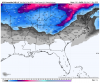
For the weenies. 12z GFS for this weekend’s clipper 
packfan98
Moderator
A friendly reminder that banter posts, gifs, and memes go in the whamby or banter threads. Thanks!
I’d love for the clipper to trend better for central Alabama, but a drive up to lookout mountain on Saturday morning wouldn’t be so bad!
ATLwxfan
Member
Went to edit my last post but saw it had already been edited by our faithful mods! Strong work.
Looks like we may have a shot at something after all per the GFS. Seemed like a third wave of energy snuck in there. Will be interesting to see how this evolves.
Sent from my iPhone using Tapatalk
Looks like we may have a shot at something after all per the GFS. Seemed like a third wave of energy snuck in there. Will be interesting to see how this evolves.
Sent from my iPhone using Tapatalk