LukeBarrette
im north of 90% of people on here so yeah
Meteorology Student
Member
2024 Supporter
2017-2023 Supporter

Gfs still shows major amp

You are correct that the time of year we’re going into that colder than average will be highs in the low to mid 50s, but there is a considerable amount of cold building in NW Canada now. While I think the coldest anamolies will continue to be towards the north and west unless we get more western ridging, no one should discount the effects that the MJO, -AO, and -NAO are going to have on muting the SER more.We will see. Either way, averages are rising so cold will likely just be mostly 50s . Maybe 40s on colder days . Of course, there are exceptions. A powerful arctic blast mid March could easily yield a 44/22 type of day . Though that doesn’t seem to be on the table as of now.
still looks troughy to me out west. the se ridge contiunues to fightYou are correct that the time of year we’re going into that colder than average will be highs in the low to mid 50s, but there is a considerable amount of cold building in NW Canada now. While I think the coldest anamolies will continue to be towards the north and west unless we get more western ridging, no one should discount the effects that the MJO, -AO, and -NAO are going to have on muting the SER more.
While yes you can get *clear* cold days like that but if we have that type of air over us more than likely 850s are below zero by a bit and if we can find a way to get precip in that we easily have chances at winter precip.We will see. Either way, averages are rising so cold will likely just be mostly 50s . Maybe 40s on colder days . Of course, there are exceptions. A powerful arctic blast mid March could easily yield a 44/22 type of day . Though that doesn’t seem to be on the table as of now.

You are correct that the time of year we’re going into that colder than average will be highs in the low to mid 50s, but there is a considerable amount of cold building in NW Canada now. While I think the coldest anamolies will continue to be towards the north and west unless we get more western ridging, no one should discount the effects that the MJO, -AO, and -NAO are going to have on muting the SER more.

At this point I would just like to have some seasonable weather. There was no winter this year AT ALL; a few days in December do not change the whole season. Seasonable weather in March isn't cold but isn't hot either; it would actually be pleasant for most. True cold and snow are very unlikely but average March weather would help keep the heat at bay for a bit. You warm guys have had it all to yourselves this winter, at least let us have a normal Spring please.We will see. Either way, averages are rising so cold will likely just be mostly 50s . Maybe 40s on colder days . Of course, there are exceptions. A powerful arctic blast mid March could easily yield a 44/22 type of day . Though that doesn’t seem to be on the table as of now.
Sorry you have to call corporate Warm Weenies inc. I’m just a low level salesman, I have no control over the weather!At this point I would just like to have some seasonable weather. There was no winter this year AT ALL; a few days in December do not change the whole season. Seasonable weather in March isn't cold but isn't hot either; it would actually be pleasant for most. True cold and snow are very unlikely but average March weather would help keep the heat at bay for a bit. You warm guys have had it all to yourselves this winter, at least let us have a normal Spring please.
At this point I would just like to have some seasonable weather. There was no winter this year AT ALL; a few days in December do not change the whole season. Seasonable weather in March isn't cold but isn't hot either; it would actually be pleasant for most. True cold and snow are very unlikely but average March weather would help keep the heat at bay for a bit. You warm guys have had it all to yourselves this winter, at least let us have a normal Spring please.
 .
.

Ok that’s the GFS operational at 384 hours. This week much of NW Canada territories are going to be seeing widespread -20 to -40 degree cold building up. Now I agree that the heart of that will be focused to the northwest as it comes into the lower 48, but we saw back during December just how much the models were trying to keep the SER flexing strong despite the strong blocking up north and they ended up wrong. Now again I’m not seeing we in the east are going to see anything like the temperature anamolies we saw around Christmas, but I am seeing I’m very concerned that we’re still going to in for some freezes at night which will have a very strong effect on our growing season. Yes I’m in the fresh produce business so this is something I follow closelyRespectfully, I’m not too sure about all that cold in Canada.

Sent from my iPhone using Tapatalk
Ok that’s the GFS operational at 384 hours. This week much of NW Canada territories are going to be seeing widespread -20 to -40 degree cold building up. Now I agree that the heart of that will be focused to the northwest as it comes into the lower 48, but we saw back during December just how much the models were trying to keep the SER flexing strong despite the strong blocking up north and they ended up wrong. Now again I’m not seeing we in the east are going to see anything like the temperature anamolies we saw around Christmas, but I am seeing I’m very concerned that we’re still going to in for some freezes at night which will have a very strong effect on our growing season. Yes I’m in the fresh produce business so this is something I follow closely
Yeah.. there have been a number of hard April freezes over the years as La Niña comes to and end.I think as the Nina influence fades and the -PNA relaxes you definitely would have concern for a frost. It could be April though which wouldn’t be unheard of and hopefully short in duration and not so damaging.
Sent from my iPhone using Tapatalk

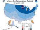
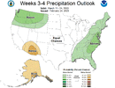
Is this a warm look? View attachment 133609View attachment 133610

March coming in like a Lion ?Have a feeling we’re gonna trend to a legit severe wx threat across the Carolinas later next week
Have a feeling we’re gonna trend to a legit severe wx threat across the Carolinas later next week
For me yes.Is this a warm look? View attachment 133609View attachment 133610
March and April is severe season. Normal.March coming in like a Lion ?
Thank you.March and April is severe season. Normal.
 Nice increase on the 18z gefs
Yeah my mud holes are drying up because we’ve only had 7.5 inches this month ?great more rain here!!lalala
Like we were saying before. Too predictable with a strong SE ridge in placeI see the Friday storm continues the NW trend. Chicago is looking good.
I see the Friday storm continues the NW trend. Chicago is looking good.
Yes, Chicago is in a great spot!!I see the Friday storm continues the NW trend. Chicago is looking good.

For th 3rd run in a row the CFSV2 45 day has double digit cold in the northeast corridor for MarchLol. It gon get cold.
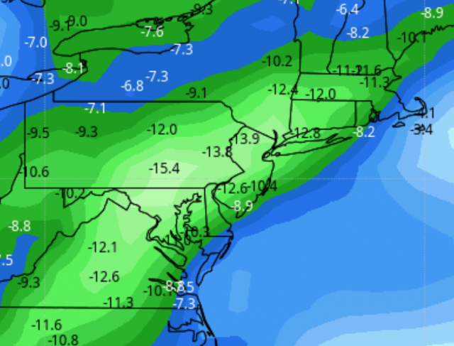
Congratulations NE.Lol. It gon get cold. View attachment 133651
Yes, I have noticed some huge 100 foot poplars are starting to leaf out, ridiculous, about a month early.This stretch of weather has just been unbelievable. All the bradford pears are out here, about a month early, I noticed my allergies already starting.
NWS has my area FINALLY seeing some seasonal weather the end of the week. Upper 50s and 30s will feel awesome!