.84 all with that storm this afternoon. Some heavy rain but it weakened big time by the time it got here, no wind, minimal lightning and thunder but at least I rest the sprinkler today.6 days into this and .44 going to have to do a lot of work to match this gfs forecast
-
Hello, please take a minute to check out our awesome content, contributed by the wonderful members of our community. We hope you'll add your own thoughts and opinions by making a free account!
You are using an out of date browser. It may not display this or other websites correctly.
You should upgrade or use an alternative browser.
You should upgrade or use an alternative browser.
Pattern May Thread
- Thread starter Detective WX
- Start date
whatalife
Moderator
Only got .85 today to go with my .75 from Saturday. @SD @Rain Cold @metwannabe I’d gladly send you the rest of the rain for this week if it meant I’d get my paver coping and concrete around my pool. Only been waiting for 5 weeks now. Looks like I’ll be waiting another week or more. ?
Please send that's more than I've gotten this monthOnly got .85 today to go with my .75 from Saturday. @SD @Rain Cold @metwannabe I’d gladly send you the rest of the rain for this week if it meant I’d get my paver coping and concrete around my pool. Only been waiting for 5 weeks now. Looks like I’ll be waiting another week or more. ?
Watch this next line break apart right when it gets in here.Please send that's more than I've gotten this month
whatalife
Moderator
I am all about sharing. I hate even making comments about sending all the rain to you because I know at some point I’ll need it back. #I’mDesperatePlease send that's more than I've gotten this month
That's the planWatch this next line break apart right when it gets in here.
Even y'all can't mess this one upThat's the plan
Brent
Member
It's amazing we're still getting these CAD events in late May.
That said, it hasn't been as bad down here, other than the persistent overcast skies. We havenn't had a sub-70*F high so far.
It's been an interesting day that's for sure. I never expected it to rain all day today either. In fact last night the models had us mostly dry

Bruh. Don't jinxEven y'all can't mess this one up
Best storm in a long time

Last edited:

Two massive rain producing thunderstorms for me today .. in a lucky pocket of 2+ inches of rain .. sorry to others but this second batch at least should be producing for a lot
Shaggy
Member
Missed the best rains here to my west but we still got probably a half inch over the day.
1.92" since late yesterday. It would be nice to keep a wet pattern going for the central and eastern US this summer (...to grow crops). Next ten days looks good (6z GFS): 
iGRXY
Member
Saw a video earlier of the funnel cloud and likely tornado that shut down Parris Bridge Rd in Spartanburg. That runs pretty parallel with 221 North to south from 85 to the state line. That was also the warned storm we saw yesterday.
Bannerdude
Member
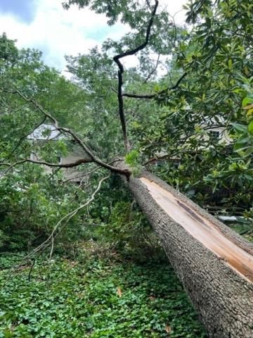
On the way home yesterday afternoon, there was a 100 yd stretch on Mineral Springs Rd just east of Hwy 70 where multiple large tree and branches were down, one of which was up against a house. Only leaves and small branches down on either side. If there was a brief spin-up, it would have been right over the area with the damage I circled in orange one frame earlier.

BufordWX
Member
Next 3 days still look fairly good for some additional rainfall across northern GA. A number of CAMs have had a northward moving batch of storms around and after sunset for this evening and Wednesday and Thursday look even more active with storms.
This was a beast yesterday! 
HSVweather
Member
I’ll be disappointed if I don’t score some rain out of this lol

NWS says an EF-0 touched down in Durham yesterday.
Sure was an active day for it to only be a level 1 risk and no watches by the SPC.
 wr.al
wr.al
Sure was an active day for it to only be a level 1 risk and no watches by the SPC.
NWS confirms EF-0 tornado in Durham County
Hundreds of customers in Durham and Chapel Hill were without power Tuesday morning after severe storms with downpours and strong winds brought down trees Monday evening.
wr.al
impressive level of activity still ongoing for late May at this hour. really not much change in overall coverage since peak heating. here's 4pm vs midnight. probably looking at a gazillion urban/flash flood warnings the next couple of days.


Downeastnc
Member
HurricaneSolomon
Member
- Joined
- Dec 6, 2021
- Messages
- 154
- Reaction score
- 276
NWS says an EF-0 touched down in Durham yesterday.
Sure was an active day for it to only be a level 1 risk and no watches by the SPC.
NWS confirms EF-0 tornado in Durham County
Hundreds of customers in Durham and Chapel Hill were without power Tuesday morning after severe storms with downpours and strong winds brought down trees Monday evening.
Yes. While I didn’t witness anything I drove by at least a part of the area I believe it hit. I saw two trees down. One tree looked to have hit the roof of one house. It was in an area between Sherron and Mineral Springs Road.
Sent from my iPad using Tapatalk
Come to papa! 52 degrees and this! 
That's my old neck of the woods. I used to live on N Mineral Springs Rd.Yes. While I didn’t witness anything I drove by at least a part of the area I believe it hit. I saw two trees down. One tree looked to have hit the roof of one house. It was in an area between Sherron and Mineral Springs Road.
Sent from my iPad using Tapatalk
smast16
Member
2.53" from Monday and Monday night, and appears more coming Thursday afternoon - Friday? Thank you dear lord baby jesus. I needed some rain as it was getting pretty dry.
Brent
Member
Good grief. Third day in a row of chilly rain and the 4th out of the last 5
HSVweather
Member
Upgraded to a slight risk today


Looks like another burst of heat coming especially in the northern parts of the region and north with a solid ridge developing near and after memorial day.
I've had some good rains now so I'll take a burst of heat. I'd actually like to see sunshine, probably just my imagination but it seems lately when we get good storms/rain chances it followed by days of clouds instead of bright days.Looks like another burst of heat coming especially in the northern parts of the region and north with a solid ridge developing near and after memorial day.
I'd like one more solid rain before going hot but I won't cry if we go hot without it. But yeah as a whole it really seems like the last few fronts have been followed by a deep NE flow reminds me much more of a winter/ early spring -pna patternI've had some good rains now so I'll take a burst of heat. I'd actually like to see sunshine, probably just my imagination but it seems lately when we get good storms/rain chances it followed by days of clouds instead of bright days.
Gfs actually has a pretty clean front passage in about 2 weeks. We will see its getting to that time of year where clearing fronts starts getting harder and harder
Yep, anytime you can get dew points in the 40s and/or 50s in June is a bonus. Lets hope we see that front.I'd like one more solid rain before going hot but I won't cry if we go hot without it. But yeah as a whole it really seems like the last few fronts have been followed by a deep NE flow reminds me much more of a winter/ early spring -pna pattern
Gfs actually has a pretty clean front passage in about 2 weeks. We will see its getting to that time of year where clearing fronts starts getting harder and harder
12z GFS ~day 14:

Yeah with the nao potentially lurking it'll help the chances of getting a nice front through with lower dews. I'm just a big skeptic with this look and the models being too excited with the frontal passageYep, anytime you can get dew points in the 40s and/or 50s in June is a bonus. Lets hope we see that front.
12z GFS ~day 14:
View attachment 118755
BufordWX
Member
HRRR has really underestimated the originization of the line of storms currently on the AL/GA border. Not a lot of eastward movement, but it is slowly moving that way.
NoSnowATL
Member
Will arrive when the heating of the day has passed our area. Probably get 7 rain drops if we are lucky.HRRR has really underestimated the originization of the line of storms currently on the AL/GA border. Not a lot of eastward movement, but it is slowly moving that way.View attachment 118756
BufordWX
Member
To be fair we haven’t even had any heating today. The wedge has been fully in control over here. Been in the mid 60s and cloudy all day. Atlanta folks might be able to get some good rainfall out of it though.Will arrive when the heating of the day has passed our area. Probably get 7 rain drops if we are lucky.
NoSnowATL
Member
True, we always find a way to suck around here.To be fair we haven’t even had any heating today. The wedge has been fully in control over here. Been in the mid 60s and cloudy all day. Atlanta folks might be able to get some good rainfall out of it though.
Last edited:
Looks like I won't be working in the garden tonight. Still badly needed though.HRRR has really underestimated the originization of the line of storms currently on the AL/GA border. Not a lot of eastward movement, but it is slowly moving that way.View attachment 118756
Brent
Member
The sun actually made an appearance earlier ?