- Joined
- Jan 23, 2021
- Messages
- 4,604
- Reaction score
- 15,203
- Location
- Lebanon Township, Durham County NC
Just about every PWS in NE Orange and NW Durham showing over 4” of rain for this week so far
Yeah I got a Laurens Electric text on my phone last night saying our power was out. Took them 2 hours to get it back on. Needed the rain though. Everything was turning brown fast.Y’all are a little moist down thereView attachment 118797
DFW made it to 91*F today, with not a cloud in the sky. Shaping up to be a top shelf holiday weekend!
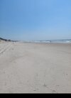
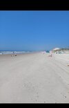
If that's the outer banks I believe it. Went with my wife last September. Stopped along the national seashore and had the whole beach to ourselves. Couldn't see anybody up and down the beach. The seashells we're everywhere.This is my kind of beach crowd on memorial day. Had the each to ourselves mostly.
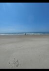
Hammocks Beach state park. It's near swansboroIf that's the outer banks I believe it. Went with my wife last September. Stopped along the national seashore and had the whole beach to ourselves. Couldn't see anybody up and down the beach. The seashells we're everywhere.
He left Johnny C back at the hotel!??@Tarheel1 My buddy had a Chris Justus sighting at Isle Of Palms lmaoView attachment 118834
Kinda hot yall

I blame alcoholWrong month
Will have to await final confirmation, but with a high of 95*F and a low of 77*F today, that should be good enough to make May 2022 the 5th warmest on record for DFW (tied with 2012).
Ooooof! ?93.7 today