Please

Sent from my SM-G955U using Tapatalk

Sent from my SM-G955U using Tapatalk


I haven't gotten a good look at things because there's no reason for me to as much anymore but this coming heatwave seems to be mainly Carolinas (okay maybe mainly SC), East Georgia, and Florida based.
In fact I'm just glancing and I'd say that now. I'd actually include Atlanta, but areas northwest of Atlanta and far North Georgia are saved. I have to imagine if we were talking about this this time next month, there'd be nobody that was lucky.
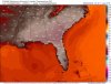
This might honestly shatter some records if it were to come true as it is as it's absolutely unreal (I feel for Phil here):
View attachment 19641
12z isn't as potent but still insane for those areas:
View attachment 19642
To allude what GaWx just stated... it's supposed to be even more brutal towards Monday/Tuesday of next week.
The EURO, verbatim from earlier was absolutely scorch city ... I mean insane heat.
The models (EURO included) have hinted at the pattern beginning to break down by mid-next week.
We'll see if that translates to *some* relief from a temperature standpoint.
The models (EURO included) have hinted at the pattern beginning to break down by mid-next week.
We'll see if that translates to *some* relief from a temperature standpoint.

Turned the sprinklers off today. Will probably have better luck with it going dormant than trying to string it along.The 12Z Euro is very hot on Fri 5/24 and downright intolerable 5/25-8 for a good portion of the SE. Needless to say with practically no rain, the drought will be worsening.
Turned the sprinklers off today. Will probably have better luck with it going dormant than trying to string it along.
Winning!Winter....spring...summer this poop never seems to change anymore
Sent from my SM-G955U using Tapatalk

Look at the bright side. Maybe the worst of the summer heat will be over before summer even begins.Winning! View attachment 19645
You guys growing cactus now down that way? At the rate we are going we will be the new southwest by 2020!Winning! View attachment 19645
Yeah Id be careful with St Augustine. From what I remember it loves water and im not sure if dormancy is an option in summerI didn’t think of that option. I don’t know if I should do that with St. Augustine grass. I’m currently watering 3 days a week late at night.
Look at the bright side. Maybe the worst of the summer heat will be over before summer even begins.