znel52
Member
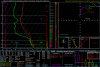
It doesn't take long to destabilize the atmosphere with good southerly flow for WAA and the sun starting to peak out. Still plenty of time for this to turn bad for the piedmont area.
What location is this sounding for? Sorry, I know I ask that a lot. Lol.
You can google the coordinates at the top to get the location. Those are along the NC/SC border east of Charlotte I think.
MBY sounding from the 3k has essentially no cape


I mean I get why they do it THESE days.. but come on, parents have to work. I didn’t think the setup warranted school cancellations. I think the timing of it was what made them jump the gun and make a poor call.You know it’s deeper than that.. they are just being as safe as possible .. if a true moderate risk was warranted then having people off the road and such is a good idea to keep everyone safe .. they acted as they should
Yeah not usually a precursor to widespread severe. But we shall see. Still a chance of some clearing I guess. ?57 and still foggy and drizzling here.

I mean I get why they do it THESE days.. but come on, parents have to work. I didn’t think the setup warranted school cancellations. I think the timing of it was what made them jump the gun and make a poor call.
Boundary trying to setup right on top of you......
After seeing the 3k I'm certainly concerned about being close to the "right" spotBoundary trying to setup right on top of you......


That’s the thing storms could be moving in as school buses are still out and traffic is much higher with car pooling going on everywhere at the same time.. increase in traffic is not good when u have scraping severe storms getting goingIt wasn't even supposed to start here until 3:00 anyway, and all the schools are out in Wake by then, but they still cancelled classes today.
My problem is the amount of 0-3km CAPE there is View attachment 79611View attachment 79612View attachment 79613View attachment 79614
That’s the thing storms could be moving in as school buses are still out and traffic is much higher with car pooling going on everywhere at the same time.. increase in traffic is not good when u have scraping severe storms getting going
Same for here in Raleigh .. don’t know why so many people thought this would bust .. Spc downgraded a bit but if you look at the ingredients coming together on models and we use info on how things usually work around here and you don’t take models surface output to heart a day out.. you could have seen this was still a recipe for some mischiefThat’s downright ugly. I knew this event wasn’t going to bust. Kept saying that last night and I got a lot of people telling me I was wrong. I said all along I didn’t like where. CLT sat when it came to this boundary.
Sent from my iPhone using Tapatalk
They could have released early. No reason to cancel the whole day when the forecast didn't call for any storms here until 3:00.
Same for here in Raleigh .. don’t know why so many people thought this would bust .. Spc downgraded a bit but if you look at the ingredients coming together on models and we use info on how things usually work around here and you don’t take models surface output to heart a day out.. you could have seen this was still a recipe for some mischief
That small line just moved through here it didn’t look like much on radar but it was absolutely torrential downpour with some pretty gusty windsWe’re there’s the area to watch moving East, plenty of time for the warm front to lift north ahead of this View attachment 79616


Hold on tight wedge!! Youve beaten back waa all winter!!!54,Foggy Chilly degrees here at the noon hour. Long Live The Wedge Baby!