Also Michael is starting to pivot looks like to me, for a while there I thought it was going to rocket up into Va
-
Hello, please take a minute to check out our awesome content, contributed by the wonderful members of our community. We hope you'll add your own thoughts and opinions by making a free account!
You are using an out of date browser. It may not display this or other websites correctly.
You should upgrade or use an alternative browser.
You should upgrade or use an alternative browser.
Tropical Major Hurricane Michael
- Thread starter ForsythSnow
- Start date
snowlover91
Member
This somewhat corroborates the earlier 62 mph gust reported in Matthews and that's in the ballpark of what I observed about 30-45 minutes ago.
It seems that lines up well with what the 12z 3km nam showed.

Webberweather53
Meteorologist
Wow look at those cooling cloud tops on the backside due to interaction with the front, starting to think some of those HRRR gust might be realized later...

Davie county southwest of the Triad just took a beating.
RollTide18
Member
My friend just told me that the Power just went out at her workplace in Winston Salem.
Two family members in Davie county are both without power.
HRRR is not showing the insane wind gust it was earlier, still some 50-60 mph gust but that's nothing like it was showing...
Webberweather53
Meteorologist
HRRR is not showing the insane wind gust it was earlier, still some 50-60 mph gust but that's nothing like it was showing...
The HRRR did have a huge overmixing bias w/ one of the CAD events around here last winter but I'm not sure which one it was though, may have been this little guy in February.
Still need to be prepared, just look at the numerous 60 mph reports out in the Triad and the problems it's causing. And those cooling cloud tops, who knows the HRRR maybe underdoing it nowThe HRRR did have a huge overmixing bias w/ one of the CAD events around here last winter but I'm not sure which one it was though, may have been this little guy in February.
View attachment 6960
Sent from my SM-G920V using Tapatalk
snowlover91
Member
Surprised there have been no tornado warnings so far in NC.
Issuing severe t-storm warnings in those counties that were not under the TS warning.... they are getting blasted out west
Severe Thunderstorm Warning
Severe Thunderstorm Warning
NCC033-157-VAC083-143-590-112015-
/O.NEW.KRNK.SV.W.0207.181011T1910Z-181011T2015Z/
BULLETIN - IMMEDIATE BROADCAST REQUESTED
Severe Thunderstorm Warning
National Weather Service BLACKSBURG VA
310 PM EDT THU OCT 11 2018
The National Weather Service in BLACKSBURG has issued a
* Severe Thunderstorm Warning for...
Rockingham County in north central North Carolina...
Caswell County in north central North Carolina...
The City of Danville in south central Virginia...
Southern Pittsylvania County in south central Virginia...
Halifax County in south central Virginia...
* Until 415 PM EDT
* At 308 PM EDT, band of showers with damaging winds were located
along a line extending from near Turbeville to near Camp Springs,
moving south at 35 mph.
HAZARD...70 mph wind gusts.
SOURCE...Radar indicated.
IMPACT...Expect considerable tree damage. Damage is likely to
mobile homes, roofs, and outbuildings.
Severe Thunderstorm Warning
Severe Thunderstorm Warning
NCC033-157-VAC083-143-590-112015-
/O.NEW.KRNK.SV.W.0207.181011T1910Z-181011T2015Z/
BULLETIN - IMMEDIATE BROADCAST REQUESTED
Severe Thunderstorm Warning
National Weather Service BLACKSBURG VA
310 PM EDT THU OCT 11 2018
The National Weather Service in BLACKSBURG has issued a
* Severe Thunderstorm Warning for...
Rockingham County in north central North Carolina...
Caswell County in north central North Carolina...
The City of Danville in south central Virginia...
Southern Pittsylvania County in south central Virginia...
Halifax County in south central Virginia...
* Until 415 PM EDT
* At 308 PM EDT, band of showers with damaging winds were located
along a line extending from near Turbeville to near Camp Springs,
moving south at 35 mph.
HAZARD...70 mph wind gusts.
SOURCE...Radar indicated.
IMPACT...Expect considerable tree damage. Damage is likely to
mobile homes, roofs, and outbuildings.
Webberweather53
Meteorologist
Surprised there have been no tornado warnings so far in NC.
Yeah I thought we'd see a few more by now, but there was one early this morning just north of Wilmington, NC
\

Yeah I was wondering about that, I've not even seen rotation....Surprised there have been no tornado warnings so far in NC.
Alex
Member
Would the lack of any spinning up so far imply, or support, anything having changed in a meteorological context?Yeah I was wondering about that, I've not even seen rotation....
Or is it just one of those things NC lucks out on so far?
Sent from my Pixel 2 XL using Tapatalk
thekidcurtis
Member
The board speaks and mother listens.

Sent from my iPhone using Tapatalk

Sent from my iPhone using Tapatalk
That just changed....Surprised there have been no tornado warnings so far in NC.
Tornado Warning
Tornado Warning
NCC033-157-VAC083-143-590-112030-
/O.NEW.KRNK.TO.W.0015.181011T1942Z-181011T2030Z/
BULLETIN - EAS ACTIVATION REQUESTED
Tornado Warning
National Weather Service BLACKSBURG VA
342 PM EDT THU OCT 11 2018
The National Weather Service in BLACKSBURG has issued a
* Tornado Warning for...
Eastern Rockingham County in north central North Carolina...
Caswell County in north central North Carolina...
The City of Danville in south central Virginia...
Southeastern Pittsylvania County in south central Virginia...
Southwestern Halifax County in south central Virginia...
* Until 430 PM EDT
* At 342 PM EDT, a severe storm capable of producing one or more
tornadoes was located over Pelham, moving south at 25 mph.
HAZARD...Tornado.
SOURCE...Radar indicated rotation.
IMPACT...Flying debris will be dangerous to those caught without
shelter. Mobile homes will be damaged or destroyed.
Damage to roofs, windows, and vehicles will occur. Tree
damage is likely.
* Locations impacted include...
Danville...
Reidsville...
Yanceyville...
Bethel...
and Jericho.
Hah...
Sent from my SM-G920V using Tapatalk
Sent from my SM-G920V using Tapatalk
Alex
Member
I'm outside on the front step smoking a cigarette and the winds are gusting good. I'm just east of Siler City, trees are being reported down there.
Sent from my Pixel 2 XL using Tapatalk
Sent from my Pixel 2 XL using Tapatalk
The winds aren’t the only thing that blowsAlso known as a Mack impersonation
Sent from my SM-G920V using Tapatalk
You talking about the HRRR right?The winds aren’t the only thing that blows
")
BHS1975
Member
Burlington reported a 49kt gust
Sent from my iPhone using Tapatalk
Sent from my iPhone using Tapatalk
Alex
Member
Alex
Member
Welp, house is getting pelted with small branches, and a transformer somewhere in Pittsboro blew.
Sent from my Pixel 2 XL using Tapatalk
Sent from my Pixel 2 XL using Tapatalk
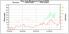
Looks like pressure down to 990 mb at RDU so pressures have begun to drop again as it transitions.....
snowlover91
Member
Burlington reported a 49kt gust
Sent from my iPhone using Tapatalk
Station appears to be down now from the wind or power loss.
B
Brick Tamland
Guest
Under a severe thunderstorm warning now.
Approaching 400k without power in NC, not sure anyone expected that.....
Looks to miss me to the north.
Welp lost power here in Durham
Alex
Member
From what I can tell Sanford (ktta) is as wellStation appears to be down now from the wind or power loss.
Sent from my Pixel 2 XL using Tapatalk
Fire scanner is getting pretty scary. Reports of multiple trees on houses in Orange county NC
BHS1975
Member
Here it comes!!

Sent from my iPhone using Tapatalk

Sent from my iPhone using Tapatalk
sunny skies and temps should start to steadily fall here now. We look to be done with it all...now to open the windows and enjoy the projected low of 52 tonight! Good luck to those of you still dealing with Michael.
Cary_Snow95
Member
Just had an insane gust in Cary. All the trees bent over
989mb currently at the house
Sent from my SM-G955U using Tapatalk
Sent from my SM-G955U using Tapatalk
Cary_Snow95
Member
Transformer in Cary just blew
Large tree just fell and crushed our ac unit. Came within a hairs with of hitting the house
Dang sorry to hear thatLarge tree just fell and crushed our ac unit. Came within a hairs with of hitting the house
Rah just throwing out blanket severe t-storm warning to cover this quick hitting band of wind..... I know this is associated with a TC transitioning to extra-tropical but this is like a derecho