There are some wind speeds approaching 90 mph above Person/Durham/Granville Counties, man the potential is there
-
Hello, please take a minute to check out our awesome content, contributed by the wonderful members of our community. We hope you'll add your own thoughts and opinions by making a free account!
You are using an out of date browser. It may not display this or other websites correctly.
You should upgrade or use an alternative browser.
You should upgrade or use an alternative browser.
Tropical Major Hurricane Michael
- Thread starter ForsythSnow
- Start date
Just had a gust to around 50 and that was it. Now just breezy.
That was solid
Sent from my SM-G955U using Tapatalk
Sent from my SM-G955U using Tapatalk
packfan98
Moderator
Lost power for two hours. Sun is out now. Bring on fall!
Blue_Ridge_Escarpment
Member
Sun is out and clearing has begun. Worst flooding here since 2004 when Frances and Ivan got us back to back. Now to how low can we go tonight. Low to mid 40s will feel perfect.
Webberweather53
Meteorologist
Rah just throwing out blanket severe t-storm warning to cover this quick hitting band of wind..... I know this is associated with a TC transitioning to extra-tropical but this is like a derecho
Derechos are usually driven by strong rear inflow jets from very deep, very long-lived convective complexes. This seems to be more along the lines of what you'd anticipate w/ a sting jet which I mentioned earlier this morning. The winds were definitely influenced by similar derecho-esque processes in areas closer to the VA border though where deep convection persisted earlier today but the strong winds are also occurring in areas almost completely devoid of any deep convection, which implies another culprit is largely at work. The sudden drop in dew points as the wind gusts moved thru many places in central NC is a signature of a sting jet as the low-levels try to dry out and hydrometeor loading superimposes onto evaporative cooling to create large-scale downdrafts that mix stronger winds down from aloft. You often see a deformation/"hook-like" appendage orientated from south-north on the back end of an area of rather intense (& often rapidly deepening) area of low pressure. Here, this rapidly deepening low we often see in sting jets may be compensated for by isallobaric processes as local pressure gradients tightened on the NW side of Michael, often more akin to what you'd see in an extratropical cyclone of course.
On the other hand, I still believe while there's definitely thermal advection across Michael atm and the +PV anomalies are becoming zonally extensive wrt the tropopause (potentially indicative of extratropical transition), there's still a pretty decent low-level, diabatic PV tower leftover in Michael so it's still a warm core, tropical system to a large extent. This is definitely starting to get into the gray area generally speaking.

Max gust on the front side was 33, 45 on the backside.
Sent from my SM-G955U using Tapatalk
Sent from my SM-G955U using Tapatalk
All the big stuff missed to the north of us. Your power ever come back on?Max gust on the front side was 33, 45 on the backside.
Sent from my SM-G955U using Tapatalk
It was on when I got home thankfully, been struggling though over the past 10 minutesAll the big stuff missed to the north of us. Your power ever come back on?
But yeah im happy the strong stuff missed to the north. I'm not sure we would get power back as quickly as we did with florence if it was taken out
Sent from my SM-G955U using Tapatalk
100 over granville now at 2300 ftVery high winds just a few thousand feet aloft above Durham County moving into Wake. Was able to find a few 100+ returns from the radar in Clayton at .5 ele.
Sent from my SM-G955U using Tapatalk
Webberweather53
Meteorologist
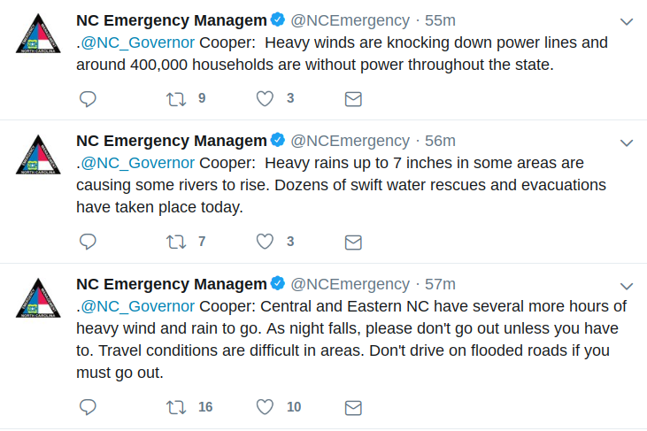
Nearly half a million people are w/o power now in NC.
We gusted to around 55 mph I would estimate
Yellow Snow
Member
I'm just in awe of the thrashing that Michael was able to give to NC today, after spending so many hours traversing over land...
I kept hearing an airplane and decided to see why. This has to suck for anyone flying and certainly for the pilots. Check out a few planes just hanging out


Sent from my SM-G955U using Tapatalk


Sent from my SM-G955U using Tapatalk
B
Brick Tamland
Guest
The big wind is here now.
Calm here right now, biggest gust so far........ 26 mphMax gust on the front side was 33, 45 on the backside.
Sent from my SM-G955U using Tapatalk
and the death band is weakening it would appear, not complaining just sayin
There are still some ripping winds just off the surface. That line just east of warrenton may be a problem for youCalm here right now, biggest gust so far........ 26 mph
and the death band is weakening it would appear, not complaining just sayin
Sent from my SM-G955U using Tapatalk
Yeah I see that, it does have me a tad concerned..... I'd actually like to keep my power on. Picked up 1.8 so far too, first rains since FlorenceThere are still some ripping winds just off the surface. That line just east of warrenton may be a problem for you
Sent from my SM-G955U using Tapatalk
Webberweather53
Meteorologist
About to cross the 600k mark for power outages in NC, unreal.
The damage is unreal near PC. High tension powerlines crumpled and a water tower pushed over. Incredible.
Yellow Snow
Member
Parts of Virginia are also feeling the effects...

It died...There are still some ripping winds just off the surface. That line just east of warrenton may be a problem for you
Sent from my SM-G955U using Tapatalk
Sent from my SM-G920V using Tapatalk
Josh (Icyclone) is posting some incredible pictures of businesses destroyed and a van tossed. It looks just like the aftermath of a EF3 or stronger tornado.
GeorgiaGirl
Member
Ended up picking up 2.55", honestly about around what most models were showing for a few days.
And preliminary pictures of Mexico Beach looked like it was completely leveled yesterday. Just a disastrous, ugly situation there.
And preliminary pictures of Mexico Beach looked like it was completely leveled yesterday. Just a disastrous, ugly situation there.
snowlover91
Member
Insane gusts here in the Wilson area. I live in the country and a huge open field on the north side of my house. Winds came ripping across the field and tore the flashing off the edge of my house on the west side.
I got hardly any rain from Michael. It was all wind. Highest gusts were likely near 50
mph with mostly 30s and a few 40s. That was enough to cause me to lose power for an hour late last night. However, I did get a much needed 2” the prior 2 days from deep moisture than came off the Atlantic that had nothing to do with Michael.
No more threatening tropical cyclones this season, please. The last 3 seasons have been way too tiring though there’s obviously an element of excitement, too, (never a dull moment) and they’re fascinating to follow. I’ll take boring and drier, cooler for awhile.
Whereas SE GA made out OK, SW GA was hit with its worst hurricane since the late 1800s! The damage is widespread. The crops there were largely devastated.
Last edited:
Bout right, RWI just reported 61 mph wind gust...Insane gusts here in the Wilson area. I live in the country and a huge open field on the north side of my house. Winds came ripping across the field and tore the flashing off the edge of my house on the west side.
Nomanslandva
Member
We were supposed to get 1-2 of rain. Ended up more like 6. Flooding in spots may have been worse than our big one in 85. River will be major but not record. There were roads flooded that I have never seen blocked before though. Now gusty but drying out. Feels good! Still keeping an eye on things because kids in eastern VA.
B
Brick Tamland
Guest
Lots more trees down and power outages around here than with Florence. The local media and meteorologists really dropped the ball saying it would not be as bad as Florence and ignored the wind threat the models were showing here the past two days.
Winds are ripping here now, my weather station, which unfortunately slightly obscured to the north by a woods, now has a peak of 31 mph but I'm guessing they have been more in the 40-45 range. Lights keep flickering off and on
snowlover91
Member
Winds are ripping here now, my weather station, which unfortunately slightly obscured to the north by a woods, now has a peak of 31 mph but I'm guessing they have been more in the 40-45 range. Lights keep flickering off and on
Stay safe, they may increase a bit more as that band moves through.
I've really got to battery backup my station. Picked up 1.71 after the power came back. Guessing we were around 3 storm total from the flooding and ponding I saw otw home from workYeah I see that, it does have me a tad concerned..... I'd actually like to keep my power on. Picked up 1.8 so far too, first rains since Florence
Sent from my SM-G955U using Tapatalk
I’m bowling so no time to read. Any 70+mph ground truth for you Nc folks?
snowlover91
Member
I’m bowling so no time to read. Any 70+mph ground truth for you Nc folks?
Several stations that got hit the hardest had power go out and stop reporting once things hit about 60-65mph so we may not know. Based on some of the damage I’ve seen I’d say areas north of highway 264 probably gusted 70+ in some spots but not widespread. Here we gusted about 60 at the peak and I have some flashing ripped off from it. Still have power thankfully.
B
Brick Tamland
Guest
Well, it really looks like fall starting tomorrow. We only needed a borderline cat 5 hurricane to change the pattern. It seems more and more we need extreme events to get a pattern change now.
B
Brick Tamland
Guest
I saw a report that 300 people stayed in Mexico Beach and only 20 people have been accounted for so far.
Webberweather53
Meteorologist
I’m bowling so no time to read. Any 70+mph ground truth for you Nc folks?
The strongest gust I officially saw was a 67 mph gust in Havelock all the way down in Craven Co of all places, I wouldn't doubt there was 70+ gusts over the northwestern piedmont north of the Triad yesterday in association with the convection on the NW side of Michael.
Webberweather53
Meteorologist
Errr no, the highest gust reported by the Triad was 56mph. That's not even close to 70+mph lol. It doesn't take much to down trees after all that rain. And Craven County - adjacent to the water in the low-lying Coastal Plain? Of course they had higher gusts.
View attachment 6968
It's entirely possible if not probable there were higher gusts than what was officially reported in just the very few sparsely distributed reporting locations in the triad, as was the case in Mecklenburg county for example. Havelock is also immediately adjacent to a national forest and was well removed from the strongest forcing associated with the remnants of this hurricane and is much more anomalous than other gusts that were reported in the southern coastal plain. It's a more reasonable assertion than saying the water temperatures were 90F along the path of Michael.
Edit: Also remember the Burlington station went out before the highest gusts moved in
Webberweather53
Meteorologist
First off, the 67mph value was from Cherry Point NKT, which is adjacent to numerous lakes and bodies of water directly to the west. There are also numerous buildings to the west, which likely funneled the winds and led to an erroneously high value. ~90 (meaning approximately, or in even simpler terms, not exactly 90) is a lot closer to 86 than 56 is to 70+, or in simpler terms less than 4 is a lot closer than more than 14.
https://nwschat.weather.gov/p.php?pid=201810120200-KMHX-NOUS42-PNSMHX
View attachment 6970
4 is stretching it a little because those were the highest values observed on its entire path but it doesn't matter much. Integrated vapor content increases exponentially as a function of temperature and the difference to a hurricane of Michael's stature w/ a nearly complete eyewall actually makes a very monumental difference and thus it's a very huge mistake when you look at it from that standpoint. Oceanic heat content had more to do w/ Michael's intensification than SST, the asymmetrical convective structure in the southern Gulf of Mexico was related to a cold eddy ring northwest of Cuba.