With the look of the OP Euro, the EPS is going to be all over Florida in theory in regards to track.
-
Hello, please take a minute to check out our awesome content, contributed by the wonderful members of our community. We hope you'll add your own thoughts and opinions by making a free account!
You are using an out of date browser. It may not display this or other websites correctly.
You should upgrade or use an alternative browser.
You should upgrade or use an alternative browser.
Tropical Major Hurricane Irma (Part 1)
- Thread starter Snowfan
- Start date
- Status
- Not open for further replies.

So that would mean it would be a strengthening Hurricane? Right ChrisWell..... guess what else that deep trof will do in that position? Vent the hell out of the area Irma is heading into
Yes! I survived that one and remember it well! The strong high gave it no escape route and forced it right into SC!
I can now say this have Hurricane Hugo name written all over, just look at the 500mb setup Wow!! This is one to keep an EYE on!!
If it avoids the larger land masses/mountains... it could make a run to a stronger Cat 4 and God Forbid, a Cat 5 as it approaches. It's 938MB by hour 216.So that would mean it would be a strengthening Hurricane? Right Chris
B
Brick Tamland
Guest
Yikes, last thing Texas needs.

Florida Keys = Kaput. Slight weakening, but nothing to write home about as it heads to the Gulf.
If this track were to verify, some disruption could occur over /near island land masses, then it gets into bath water, RI before hitting or just brushing S Florida? The great Labor Day hurricane, was that the keys?So that would mean it would be a strengthening Hurricane? Right Chris
Closer look back at hr 216: just passing along from WU
Storm5
Member
This would not be a good solution

Sent from my SM-J320VPP using Tapatalk

Sent from my SM-J320VPP using Tapatalk
Storm5
Member
Worlds apart
12z gfs
12z euro


Sent from my SM-J320VPP using Tapatalk
12z gfs
12z euro


Sent from my SM-J320VPP using Tapatalk
Whew, close one for Key West. Of course, they would be feeling big waves/surge one would assume.

Wouldn't that solution turn it into Fl into the Ga/SC Area??This would not be a good solution
Sent from my SM-J320VPP using Tapatalk
Bama Ravens
Member
When did it become 2005 again?
B
Brick Tamland
Guest
Crazy how different the Euro and GFS are.
Storm5
Member
Not with that massive ridge parked off the east coastWouldn't that solution turn it into Fl into the Ga/SC Area??
Sent from my SM-J320VPP using Tapatalk
Brent
Member
The euro is disturbing me it's like almost never wrong when it's consistent
pcbjr
Member
If that were to verify, I'd be concerned out towards Mobile and west a tad, though ...Not with that massive ridge parked off the east coast
Sent from my SM-J320VPP using Tapatalk
I really hope this DON'T be another Texas/LA Storm!!
Yeah that has somewhere between Pensacola and New Orleans written all over it.... verbatim that run of courseNot with that massive ridge parked off the east coast
Sent from my SM-J320VPP using Tapatalk
B
Brick Tamland
Guest
No way Jose!
whatalife
Moderator
Man those solutions look bad!
ForsythSnow
Moderator
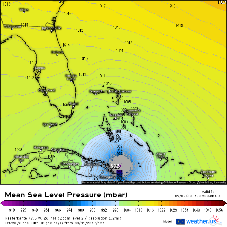
Latest info puts Irma at a major hurricane. We will see it at the 5 PM advisory.
Ryan Maue has started real time EPS spaghetti modeling for subscribers.
Storm5
Member
OmgdRyan Maue has started real time EPS spaghetti modeling for subscribers.
Sent from my SM-J320VPP using Tapatalk
B
Brick Tamland
Guest
Not sure you could thread the needle any better than what the Euro shows.
Based on the 12Z EPS mean hours 228+, I'm afraid it is going to show a number of hits on FL, further up the SE US coast, and in the E GOM for a week from SAT night through a week from Tue.
In deference to the Euro, I'm raising the CONUS hit % chance in my mind from 15% to 25%.
***Edit: a week from Sat night through Tue.
In deference to the Euro, I'm raising the CONUS hit % chance in my mind from 15% to 25%.
***Edit: a week from Sat night through Tue.
Ryan Maue has started real time EPS spaghetti modeling for subscribers.
Yeah that's just freaking cool.... just signed up for the free trial, I'm sure I'll get sucked into subscribing...
EPS certainly has some ots solutions but most are a legitimate US threat but overall little more north than the Op run
ForsythSnow
Moderator
Yeah, I would say that right now it seems to be targeting Florida to NC at the most per the EPS, but focused on Florida.EPS certainly has some ots solutions but most are a legitimate US threat but overall little more north than the Op run


WeatherWatch
Member
Sent from my SM-J700T1 using Tapatalk
Storm5
Member
That was the coolest thing

Sent from my SM-J320VPP using Tapatalk

Sent from my SM-J320VPP using Tapatalk
Storm5
Member
Yeah kinda two camps . OTS and hits from VA down intp the gulfEPS certainly has some ots solutions but most are a legitimate US threat but overall little more north than the Op run
Sent from my SM-J320VPP using Tapatalk
B
Brick Tamland
Guest
EPS mean looks to have more tracks to the east coast than the Gulf.
BHS1975
Member
Yeah with the massive trough taking a huge bite out of the ridge a gulf track seems unlikely.
Sent from my iPhone using Tapatalk
Sent from my iPhone using Tapatalk
Storm5
Member
That eps run was a NE shift . Remember the gefs favors OTS at the moment . So out to sea or staying just offshore has just as much a chance as a hit at the moment
Sent from my SM-J320VPP using Tapatalk
Sent from my SM-J320VPP using Tapatalk
Storm5
Member
No track is likely or unlikely at this point . We dont even know how strong the trough will be , the ridge placement in the Atlantic ( see the gfs and euro , worlds apart)Yeah with the massive trough taking a huge bite out of the ridge a gulf track seems unlikely.
Sent from my iPhone using Tapatalk
Gonna be days before we can rule out track directions
Sent from my SM-J320VPP using Tapatalk
- Status
- Not open for further replies.