accu35
Member
So is it straight west motion?Irma has definitely made a non-negligible wobble to the west the past few hours, circulation back up to about 18N again.

So is it straight west motion?Irma has definitely made a non-negligible wobble to the west the past few hours, circulation back up to about 18N again.
The ensembles haven't run yet for 12zGFS ensemble consensus still remains on a North Carolina hit.
GFS ensemble consensus still remains on a North Carolina hit.
The ensembles haven't run yet for 12z
The 11AM NHC coordinates are 17.7N, 48.4W. That means that she is located to the south of all 50 0Z EPS members! ALL of them are between 18N and 20.5N when at 48.4W. This is a very significant indicator and, therefore, I'm fully expecting further SW adjustments in the EPS mean and probably also in the more volatile Euro operational as well as general model consensus as we move forward.
Larry,^I'm embarrassed to say that I erred badly. I thought that the boxes were the standard 5 degrees x 5 degrees. But I now see the latitude intervals of the boxes are only 3 degrees even though the longitudes are 5 degrees. So, the quoted post is flat out wrong. I apologize. This is definitely embarrassing.
So, I thought the top of the box I was analyzing was at 20 N. But the top is at 18 N rather than 20 N. So, with that correction, I can say that the 11 AM NHC position of 17.7 N, 48.4 W, is actually very near the 0Z EPS mean. Furthermore, IF the current westerly movement is more than just a wobble, Irma may actually be heading north of the 0Z EPS mean. Again, sorry about my error.
No need to be embarrassed. You contribute so much to this forum and nobody is perfect !^I'm embarrassed to say that I erred badly. I thought that the boxes were the standard 5 degrees x 5 degrees. But I now see the latitude intervals of the boxes are only 3 degrees even though the longitudes are 5 degrees. So, the quoted post is flat out wrong. I apologize. This is definitely embarrassing.
So, I thought the top of the box I was analyzing was at 20 N. But the top is at 18 N rather than 20 N. So, with that correction, I can say that the 11 AM NHC position of 17.7 N, 48.4 W, is actually very near the 0Z EPS mean. Furthermore, IF the current westerly movement is more than just a wobble, Irma may actually be heading north of the 0Z EPS mean. Again, sorry about my error.
for now, it appearsSo is it straight west motion?


Could the Straight West Motion affect Long Term Track??
NOOOOO!. On another note, look at the mean for the 500mb level. The ridged fully connect, hence the FL, GA, SC, and NC landfalls.12z GEFS
Sent from my iPhone using Tapatalk

So is it straight west motion?
12z GEFS
Sent from my iPhone using Tapatalk
12z GEFS
Sent from my iPhone using Tapatalk
12z GEFS
Sent from my iPhone using Tapatalk
A few members are starting to sneak into the Gulf through the Florida straits, that's the last thing that needs to happen
Doubt the entire peninsula would need evacuation.If this does end up affecting the FL peninsula I don't see how they're going to evacuate the entire state of FL, that said I think this is going to affect the Carolinas.
I really hope it doesn't but it looks like OTS isn't likely now...
12z GEFS
Sent from my iPhone using Tapatalk

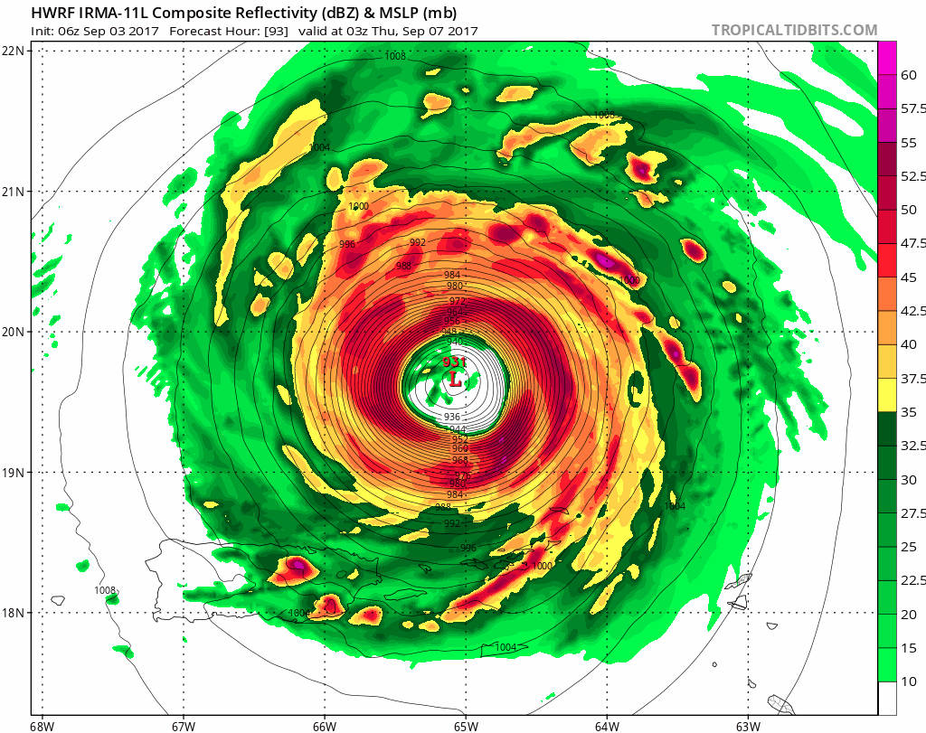
HWRF thinks Irma will become a 125 knot category 4 hurricane by tomorrow morning...
View attachment 1057
NOOOOO!. On another note, look at the mean for the 500mb level. The ridged fully connect, hence the FL, GA, SC, and NC landfalls.
And look what is sitting just to the north of Irma12z GEFS
Sent from my iPhone using Tapatalk
That’s almost a look of a very rare GA hitNOOOOO!. On another note, look at the mean for the 500mb level. The ridged fully connect, hence the FL, GA, SC, and NC landfalls.

Yeah OTS is pretty much off the table.
Its crazy to know the category intensity is lower now then they use to.when Ivan hit us in Pcola it hit as a cat 3 with winds up to 130 mph. But now a cat 4 is 125? When did this change?HWRF thinks Irma will become a 125 knot category 4 hurricane by tomorrow morning...
View attachment 1057
2 landfalls for GA on this run, both Savannah head on. The rest are SC or NC, or FL.That’s almost a look of a very rare GA hit

Cat 4 is 130 now, and was 135 a few years ago.Its crazy to know the category intensity is lower now then they use to.when Ivan hit us in Pcola it hit as a cat 3 with winds up to 130 mph. But now a cat 4 is 125? When did this change?
Not quite yet but if this goes OTS it's going to be painfully slow in doing so and its feasible this could challenge the all time record for individual storm ACE for an Atlantic tropical cyclone if it somehow remains well offshore the entire time...
Check a knot to mph conversion calculator.Its crazy to know the category intensity is lower now then they use to.when Ivan hit us in Pcola it hit as a cat 3 with winds up to 130 mph. But now a cat 4 is 125? When did this change?

2 landfalls for GA on this run, both Savannah head on. The rest are SC or NC, or FL.