look at the bright side, at least summer is over and you dont have to worry about the house getting too hot.If this local AccuWeather forecast even comes close to verifying, you and I will probably be speaking again in October (once power and internet are restored in Gainesville) -

-
Hello, please take a minute to check out our awesome content, contributed by the wonderful members of our community. We hope you'll add your own thoughts and opinions by making a free account!
You are using an out of date browser. It may not display this or other websites correctly.
You should upgrade or use an alternative browser.
You should upgrade or use an alternative browser.
Tropical Major Hurricane Irma (Part 1)
- Thread starter Snowfan
- Start date
- Status
- Not open for further replies.
pcbjr
Member
You don't live here - it'll be 90º a day after and will stay in the upper 80's until sometime in October ...look at the bright side, at least summer is over and you dont have worry about the house getting too hot.
DadOfJax
Member
Spann is live on FB right now and honestly I think he is focusing too much on where the center is forecast to go without mentioning the possibility that it could shift further east or west.
Why?....Doesn't he know there will be ZERO impact to Alabama? What could he possibly talking about? #sarcasm
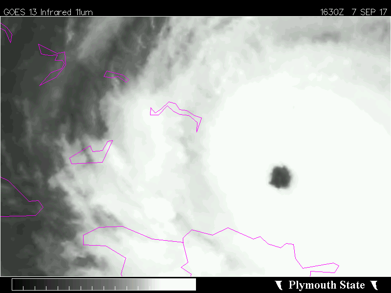
I don't know what's going on internally, but presentation wise, this is the best I've seen Irma look all day today. Especially on the western side of the hurricane.

Storm5
Member
Not to mention tornadoesI'm not sure. Even with the 12z tracks we could gust 45-50
Sent from my SM-G955U using Tapatalk
Sent from my SM-J320VPP using Tapatalk
- Joined
- Sep 4, 2017
- Messages
- 216
- Reaction score
- 260
If you look over TX and just west of Jamaica in this loop. Don't discount the role that TX ridge and the ULL are having or will have. That ridge over performs it could start to pinch the trof between itself and the Bermuda, WAR, the big ol ridge out to sea, and alter the SW to not dig as deep and/or lift out sooner That ULL is is actually working in tandem with the slowly building BOR (Big Ol' Ridge) to counter the urge Irma has to go poleward. I think the development of those 2 feature over the next 24-36 hours is going to have a substantial impact on where Irma will be and where it will be heading come Sat. evening.
Just my armchair opinion:weenie:
https://weather.msfc.nasa.gov/cgi-bin/basicLooper.pl?category=goes16abiconus®ex=simpleWaterVapor&title=GOES-16 ABI - Simple Water Vapor&time_drop=show
Just my armchair opinion:weenie:
https://weather.msfc.nasa.gov/cgi-bin/basicLooper.pl?category=goes16abiconus®ex=simpleWaterVapor&title=GOES-16 ABI - Simple Water Vapor&time_drop=show
dsaur
Member
I survived the Bliz and those winds were gusting at what these might be, so it's the nasty little tornadoes that spin up by the dozens I don't likeI was looking around on NOAA's site and found a map of all of the hurricane tracks over the past 150 years. I only see 3 that are similar to the UK/Euro/18 z GFS tracks. All were unnamed storms and occurred prior to 1940. As long as it stays out of the gulf and we are on the east side, we should be spared most of the carnage, I think.
") Give me a blizzard any day, Kyle Hope this track continues to change into Sat. Tony
Give me a blizzard any day, Kyle Hope this track continues to change into Sat. TonyI buy the NW slingshot. I'm still up in the air about when the turn occurs and how much if any easterly movement it has once that turn happensI think you are more likely to get those then me, not that I'm complaining... still curious to see when these turns actually occur. Most big canes feel the weakness to turn poleward fairly quickly but are slower to respond to the tug of an ULL so I'm not convinced of any track until it actually turning. That hard NW slingshot effect I'm just not sold on yet.....
Sent from my SM-G955U using Tapatalk
Xtreme Weather
Member
HMON pounds Miami to W Palm Beach...will mention it to has jogged W as well a bit
NWMSGuy
Member
Not sure if this question has already been posed but if Miami was to take a direct hit (hopefully not) how would NHC proceed with operations? I assume they are in a very well constructed building but with such a storm you would think they would lose some kind of support/functionality.
So do you think it could move further east in FL or a Western FL track?If you look over TX and just west of Jamaica in this loop. Don't discount the role that TX ridge and the ULL are having or will have. That ridge over performs it could start to pinch the trof between itself and the Bermuda, WAR, the big ol ridge out to sea, and alter the SW to not dig as deep and/or lift out sooner That ULL is is actually working in tandem with the slowly building BOR (Big Ol' Ridge) to counter the urge Irma has to go poleward. I think the development of those 2 feature over the next 24-36 hours is going to have a substantial impact on where Irma will be and where it will be heading come Sat. evening.
Just my armchair opinion:weenie:
https://weather.msfc.nasa.gov/cgi-bin/basicLooper.pl?category=goes16abiconus®ex=simpleWaterVapor&title=GOES-16 ABI - Simple Water Vapor&time_drop=show
accu35
Member
All depends on the turnSo do you think it could move further east in FL or a Western FL track?
pcbjr
Member
We are not talking about a bass boat; that thing is an aircraft carrier ... will turn accordingly, IMHO ...So do you think it could move further east in FL or a Western FL track?
Weather Prediction Center takes over and issues warnings while NHC are offline.Not sure if this question has already been posed but if Miami was to take a direct hit (hopefully not) how would NHC proceed with operations? I assume they are in a very well constructed building but with such a storm you would think they would lose some kind of support/functionality.
Nomanslandva
Member
Hey NOAA. It would be really cool if you could overlay the model tracks on the floater satellite loops
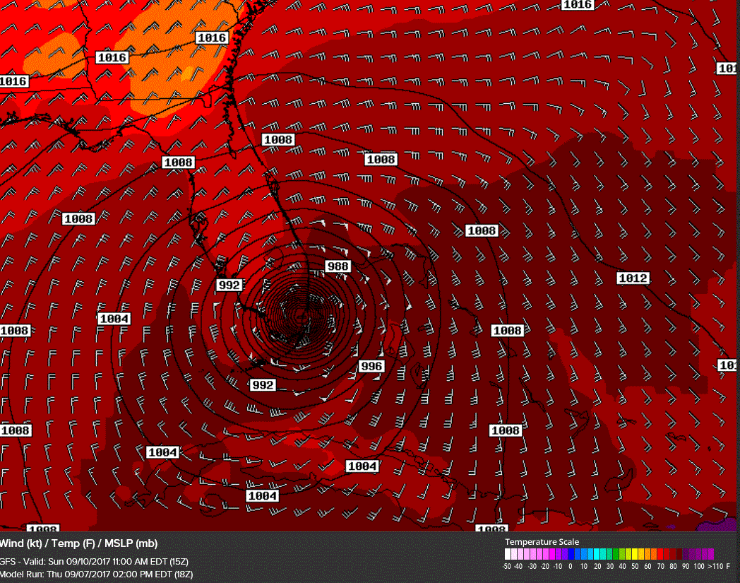
Irma taking a noticeable turn due west atm, not sure if a significant wobble or that westward bend is commencing..
I don't know what's going on internally, but presentation wise, this is the best I've seen Irma look all day today. Especially on the western side of the hurricane.
Absolutely, gaining symmetry on all side with the eye in the middle of a cooling CDO.
NWMSGuy
Member
Interesting!!Weather Prediction Center takes over and issues warnings while NHC are offline.
accu35
Member
Gefs running slow
WeatherWatch
Member
North Georgia folks, here is my new blog
The Impacts for North Georgia from Hurricane Irma
http://northgawxinfo.blogspot.com/2017/09/the-impacts-for-north-georgia-from.html
The Impacts for North Georgia from Hurricane Irma
http://northgawxinfo.blogspot.com/2017/09/the-impacts-for-north-georgia-from.html
Brent
Member
Not sure if this question has already been posed but if Miami was to take a direct hit (hopefully not) how would NHC proceed with operations? I assume they are in a very well constructed building but with such a storm you would think they would lose some kind of support/functionality.
Their building is built to withstand a category 5 but the issue would be if communications went down mostly. They stayed up in andrew and had 160 mph winds then (tore the radar off the roof then) but yeah the wpc is backup and they apparently sent staff to the wpc in case it comes down to it
Last edited:
Gonna make that run at sub 900!?Absolutely, gaining symmetry on all side with the eye in the middle of a cooling CDO.
NWMSGuy
Member
Good stuff and smart move on their part!Their building is built to withstand a category 5 but the issue would be if communications went down mostly. They stayed up in andrew and had 160 mph winds then (tore the radar off the roof had) but yeah the wpc is backup and they apparently sent staff to the wpc in case it comes down to it
B
Brick Tamland
Guest
So, there's actually a couple named Harvey and Irma that have been married 75 years.
https://nyti.ms/2xez2xH
https://nyti.ms/2xez2xH
accu35
Member
pcbjr
Member
Is that a slight SW jog/wobble at the end?
accu35
Member
Yes sirIs that a slight SW jog/wobble at the end?
Irma over Chattanooga hour 105 HMON good grief tennessee valley bound after GA

accu35
Member
MichaelJ
Member
No, it just turns straight west from wnwIs that a slight SW jog/wobble at the end?
Well I don't know if it was posted the 18z GEFS matches the Euro and UKMet. I believe our track is just about set.
Xtreme Weather
Member
Recon passing into the eye will be interesting
BHS1975
Member
No, it just turns straight west from wnw
Yeah stair stepping is pretty common.
Sent from my iPhone using Tapatalk
Starting to get concerned myself. Have quite a few tall pines on top of a hill in the back yard and if they come down...it'll be right on the house. Yuck.
Same issue with three large pines on a hill just west of my house. Thought about calling the tree guys to knock them down but I know they are probably swamped with work.
GEFS

BHS1975
Member
GEFS
That one to the far right must be with no short wave.
Sent from my iPhone using Tapatalk
W
WeatherLC
Guest
Hey guests please sign up. Not only will you get more access to the site, you will also get to enjoy access to our store, can view more images etc. sign up tonight!
skywatcher
Member
If you have what's happening imby questions, it would be best to include your location in your profile.What did it show for GA?
weatherguy
Member
Interesting Fujiwhara effect with Irma and the upper level low on most of the models causing it to turn west and loop.
- Status
- Not open for further replies.