• Hello, please take a minute to check out our awesome content, contributed by the wonderful members of our community. We hope you'll add your own thoughts and opinions by making a free account!

Tropical Major Hurricane Helene

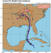
Looks like it’s gonna be a interesting track for this storm. Is definitely gonna come NW hard after landfall.

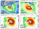
ICON should landfall close to the GFS.


The 12Z Icon is much quicker than its prior runs and is now much closer to the timing of the consensus. Although much further E early, this much quicker movement allows it to be captured by the cutoff H5 low and it then moves N to near Panama City at 984 mb late Thu night followed by a NNW move through AL.
 
Regardless of the eventual track, the storm will move inland at a good clip.

The good news is that excessive rainfall should be limited.
The bad news is that the storm will reach the latitude of Atlanta within 12 hours post-landfall and will be baroclinically enhanced. High winds far inland are a real concern if the storm reaches the coast as an intense hurricane.
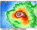
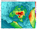
Just to echo this point here’s the GFS wind gusts from 6z. You can probably cut 20-30% off these numbers but even that would still cause power outages up thru AtlantaIMG_0213.png
 
Just to echo this point here’s the GFS wind gusts from 6z. You can probably cut 20-30% off these numbers but even that would still cause power outages up thru AtlantaView attachment 151432
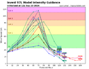
Yep, and that's assuming a +- 975 Mb landfalling marginal Cat 2. The ceiling is higher and is concerning.
 
Just to echo this point here’s the GFS wind gusts from 6z. You can probably cut 20-30% off these numbers but even that would still cause power outages up thru AtlantaView attachment 151432

In my experience to really push big wind well inland the system has to have a large well-developed wind field, typically you see these on systems that have undergone a few ERC's and had time to expand and form that strong CDO . Forward speed also plays a huge role obviously if the center comes in moving north at 25 miles a hr everyone gets peak conditions for a shorter time frame but it can carry those winds further inland.
 
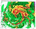
Not sure on the difference in pressure between TropicalTidbits and WxBell. Either way that’s a catastrophic hit if it were to happen
 
Not sure on the difference in pressure between TropicalTidbits and WxBell. Either way that’s a catastrophic hit if it were to happen
I think it's because I'm zoomed in on the SE. I would think Cat 4 at landfall is the upper limit and unlikely, but still.
 
Back
Top