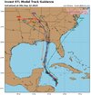
The 18Z Icon is well E of the 12Z with landfall back down to the middle of the Big Bend (987) followed by a NNE track. So, this shows plenty of uncertainty remains as one would expect, especially with no storm yet.
-
Hello, please take a minute to check out our awesome content, contributed by the wonderful members of our community. We hope you'll add your own thoughts and opinions by making a free account!
You are using an out of date browser. It may not display this or other websites correctly.
You should upgrade or use an alternative browser.
You should upgrade or use an alternative browser.
Tropical Major Hurricane Helene
- Thread starter SD
- Start date
- Status
- Not open for further replies.
Slightly east of 12z. Similar strength 
NoSnowATL
Member
Digs deeper, more pull to the NE on 18Z models so far.
Holy crap lol

Once again ULL location is key, 18z GFS is farther SE so it results in a longer NE movement before the NW turn.
Ron Burgundy
Member
From FFC disco this afternoon:
“Ensemble guidance continues to indicate an area of low pressure
forming over the Yucatan Peninsula before moving into the
western/central Gulf of Mexico. NHC is now carrying an 80% chance
for tropical development over the next 7 days. Current EPS and GEFS
ensemble forecast tracks are indicating that anywhere from the
Louisiana/MS coast line to Florida for any potential landfall at
this time although models are beginning to come together better.
Would like to see another run or two of consensus before
certainty increases on our end. Another factor coming into play
is how this troughing plays out over the eastern CONUS and how it
will help steer the system. Current rainfall totals have gone up
to around 3- 4" over the weekend but again with the uncertainty
this is highly subject to change. More information should come
together over the next couple of days although uncertainty still
remains.”
- Joined
- Jan 5, 2017
- Messages
- 3,802
- Reaction score
- 6,051
HFAS is running at 18Z for 97L on Tropical Tidbits. Should be interesting.
That is pretty consistent at this range is it not?18Z GEFS mean: even further west (near Pensacola), which is 50 miles W of 12Z mean and then the mean is N into AL
SnowwxAtl
Member
I think it is going to go farther east
Henry2326
Member
HWRF coming up now tooHFAS is running at 18Z for 97L on Tropical Tidbits. Should be interesting.
That is pretty consistent at this range is it not?
Yes, fairly consistent
Belle Lechat
Member
- Joined
- Aug 29, 2021
- Messages
- 1,547
- Reaction score
- 1,224

18z Euro only goes out to 90. But ends here. Stronger than 12z. I would guess if extended it would go near Apalachicola or slightly east 
Henry2326
Member
. Northwestern Caribbean Sea and Gulf of Mexico (AL97):
Disorganized showers and thunderstorms located over the northwestern
Caribbean Sea and portions of Central America are associated with a
broad area of low pressure. Environmental conditions appear
conducive for development of this disturbance, and a tropical
depression or tropical storm is likely to form during the next few
days while the system moves northward across the northwestern
Caribbean Sea and into the southeastern Gulf of Mexico. Regardless
of development, this disturbance is expected to produce heavy rains
over portions of Central America during the next several days.
Interests in the northwestern Caribbean, the Yucatan Peninsula of
Mexico, and western Cuba should closely monitor the progress of this
feature. Later this week, the system is forecast to move generally
northward across the eastern Gulf of Mexico, and interests along the
northern and northeastern Gulf Coast should also monitor the
progress of this system.
* Formation chance through 48 hours...medium...50 percent.
* Formation chance through 7 days...high...80 percent.
HAFS-B first run. 960mb

Gulf SSTs: ~86 where disturbance is now (not on this map); warms to ~88 as it moves NW to near Yucatan and then only gradually cools back to 86 and then cools only to ~84 just offshore the N Gulf coast. Not good news if you don’t want the potential for a very strong storm:

Drizzle Snizzle
Member
Don't hurricanes usually weaken when they get to the Northern Gulf this time of year ? I know Opal weakened pretty substantially before landfall.Gulf SSTs: ~86 where disturbance is now (not on this map); warms to ~88 as it moves NW to near Yucatan and then only gradually cools back to 86 and then cools only to ~84 just offshore the N Gulf coast. Not good news if you don’t want the potential for a very strong storm:
View attachment 151463
Don't hurricanes usually weaken when they get to the Northern Gulf this time of year ? I know Opal weakened pretty substantially before landfall.
In the past yes, but in the last ten years, no. Michael, Laura, Ida and Ian were either strengthening or staying steady at landfall.
Don't hurricanes usually weaken when they get to the Northern Gulf this time of year ? I know Opal weakened pretty substantially before landfall.
It varies depending on things like shear, dry air, and SSTs. But SSTs are AN/84 near the coast, not cool enough for much, if any, weakening. Models are currently hardly weakening it at all til landfall.
lexxnchloe
Member
And there has been so little disruption for so long to mix the water. Nothing but a giant ridge heating the gulf for months now.It varies depending on things like shear, dry air, and SSTs. But SSTs are AN/84 near the coast, not cool enough for much, if any, weakening. Models are currently hardly weakening it at all til landfall.
1. MichaelDon't hurricanes usually weaken when they get to the Northern Gulf this time of year ? I know Opal weakened pretty substantially before landfall.
2. Ian
3. Laura
4. Ida
5. Etc
Webber mentions potential for shear coming from 10e in EPAC impacting early development
BHS1975
Member
Webber mentions potential for shear coming from 10e in EPAC impacting early development
Yeap it's blowing up.
Sent from my iPhone using Tapatalk
Brent
Member
1. Michael
2. Ian
3. Laura
4. Ida
5. Eta
Harvey started it...
But yeah 10-E is something to watch too to see if it has any impact
lexxnchloe
Member
Euro 5 mb stronger than 12Z

BHS1975
Member
ICON looks tame.
Sent from my iPhone using Tapatalk
Sent from my iPhone using Tapatalk
Henry2326
Member
If it was just one, maybe overdone.....but all of them??
Brent
Member
If it was just one, maybe overdone.....but all of them??
Use caution til we have a center
Henry2326
Member
Last time that happened it was Michael.....and we know how that ended.Use caution til we have a center
Michael strengthened right up until landfall. A lot of it depends on if an EWRC takes place and it’s timingDon't hurricanes usually weaken when they get to the Northern Gulf this time of year ? I know Opal weakened pretty substantially before landfall.
Storm5
Member

Snowlover34
Member
Regardless how big of an impact this potential storm may bring sections still in the southeast can use the rain.
Darklordsuperstorm
Member
I'm encouraged by the NW turn inland that's showing up pretty consistently. Hoping I end up on the wet side.Regardless how big of an impact this potential storm may bring sections still in the southeast can use the rain.
I’ll actually be surprised if that verifies as much as depictedI'm encouraged by the NW turn inland that's showing up pretty consistently. Hoping I end up on the wet side.
That does seem a bit odd looking. I’m not sure I’ve ever seen a gulf storm turn back to the west that sharply once inland.I’ll actually be surprised if that verifies as much as depicted
- Status
- Not open for further replies.