kennedybb6
Member
I am wondering if someone can explain the dynamics that would pull it to the west and not east thanks for all the information you guys provide for novice people like me
In NC, nothing interesting exists for hurricanes.I'm fortunate to live in a bit of a valley with underground utilities so weather-related power failures are uncommon. I would think worst case inland wind near me would be 40mph with higher gusts. But with the trees all still leafed out, that is plenty enough to take down plenty of trees of which I have many.
Anyone living at elevation should be especially prepared since the risk of inland wind damage is higher than usual with this setup.
I am wondering if someone can explain the dynamics that would pull it to the west and not east thanks for all the information you guys provide for novice people like me

The position of the cut off is everything. If it digs more it’s east. Stay west or north it’s going a little west as it’s closer to landfall. Also the H east of Florida is very important . It’s a one state different and it means a lot.I am wondering if someone can explain the dynamics that would pull it to the west and not east thanks for all the information you guys provide for novice people like me
Nothing is west. Appcola is the most west I see.It's the upper low over Arkansas
Now I'm not saying it won't shift east nobody knows for sure but that is why the models are so far west right now. Whether they are right or not remains to be seenView attachment 151495
Nothing is west. Appcola is the most west I see.
It will perhaps have a pseudo-Fujiwhara Effect on it with a separate upper low parked over Arkansas. Check out link below:I am wondering if someone can explain the dynamics that would pull it to the west and not east thanks for all the information you guys provide for novice people like me
not even pseudo, it's the full blown thing, things could get a little weird once this thing makes landfallIt will perhaps have a pseudo-Fujiwhara Effect on it with a separate upper low parked over Arkansas.
Fujiwhara Effect
I'd say PCB at the most extreme but that's only if the trough lags behind some. There's a tight consensus though.Nothing is west. Appcola is the most west I see.

Well, maybe bad choice of words, just meaning one is not a hurricane.not even pseudo, it's the full blown thing, things could get a little weird once this thing makes landfall

Here we go!!!
The National Hurricane Center will initiate advisories on Potential Tropical Cyclone Nine, located over the central Gulf of Mexico, at 1100 AM EDT.

I think the cut off digs more and is more east and will be closer to N Miss. I will say Alligator point is landfall location. High Cat 3I'd say PCB at the most extreme but that's only if the trough lags behind some. There's a tight consensus though.
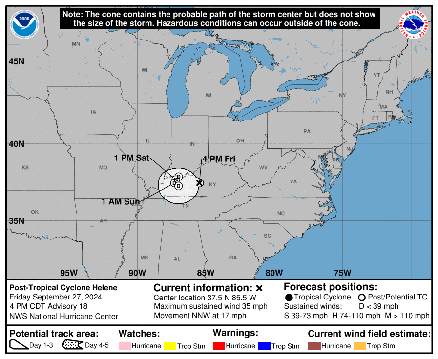
It happened!PTC likely later this morning
Regardless of development, this system is expected to produce heavy
rains over portions of Central America during the next several days.
Interests in the northwestern Caribbean, the Yucatan Peninsula of
Mexico, and western Cuba should closely monitor the progress of this
system, as watches or warnings will likely be required later
this morning for portions of these areas. Later this week, the
system is forecast to move generally northward across the eastern
Gulf of Mexico, and interests along the northern and northeastern
Gulf Coast should also closely monitor the progress of this system.
* Formation chance through 48 hours...high...80 percent.
* Formation chance through 7 days...high...90 percent.
no don't worry i get it, i thought and said the exact same thing in a group chat this morning until somebody replied with the 500mb evolution and i was like wow... i stand corrected...Well, maybe bad choice of words, just meaning one is not a hurricane.
to me i'm unsure consensus necessarily equates to certainty, i think the ULL impacting steering injects some more variability than usual- we all know how much of a PITA they can be to forecastI'd say PCB at the most extreme but that's only if the trough lags behind some. There's a tight consensus though.
Because you haven’t experienced a bad one! I grew up in Harnett and you would have lost your mind during Fran if a little power outage bothers you!In NC, nothing interesting exists for hurricanes.

dont see it yetPlane is off now. It'll be later this afternoon before it gets to the system but we'll see if there's a designation above PTC by 5 most likely. I'm seeing two rotations on visible which could just be the mid and low level circulations though.

It is. Or at least the effect is the same.It will perhaps have a pseudo-Fujiwhara Effect on it with a separate upper low parked over Arkansas. Check out link below:
Fujiwhara Effect

It looks to me like this has to go NNW through Al into Tenn with this 500mb flow. Of course, things will change many times before then.It is. Or at least the effect is the same.
FWIW, the 12Z NAM is a bit west as a direct result of the ULL being SW of some of its earlier solutions.
View attachment 151503

Saw that and that's very telling on how they see this. Few storms initialize at that level and don't become massive. Ian also was at max that on advisory 1.110 mph peak on the first forecast
Michael hit that same area at 919....I'm not sure the destruction is much different from 930 to 919, or even 900.The good news about the HMON is it was significantly weaker than 0z. Still a strong storm though.
Hey, not in the path of storm!!!
Folks in Florida better start charging their phones NOW!Hey, not in the path of storm!!!

Not enough time to get to a cat 5 I don’t thinkAs my experience I've been tracking storm since 2000 I must say this is going to be a cat 3 moving very fast I don't see this getting a cat 5 or 4