-
Hello, please take a minute to check out our awesome content, contributed by the wonderful members of our community. We hope you'll add your own thoughts and opinions by making a free account!
You are using an out of date browser. It may not display this or other websites correctly.
You should upgrade or use an alternative browser.
You should upgrade or use an alternative browser.
Tropical Major Hurricane Helene
- Thread starter SD
- Start date
- Status
- Not open for further replies.
My family in south Spartanburg says its like a war zone. Power has been off and on, my dad has been going around cutting trees out of neighbors houses and clearing streets in the neighborhood, and there have been gas lines hit to multiple houses requireing the fire department multiple times since yesterday. Very few gas stations have been open in spartanburg with waits being over 45min at some and lines of cars waiting for gas trucks to deliver more as many gas stations have been running out. Of the grocery stores open many are not selling anything cold or frozen and marking it as spolied. Many places are also price gouging, some that are selling charcoal are charging upwards of $30 for small bags and much more for larger. There are still many roads that are completely impassable and much of the county still does not have power. Very sad stories coming out of all of the effected areas. I hope everyone continues to stay safe as the impacts of this continue to get sorted out!
Sctvman
Member
Yikes. That’s from Statesville on on I-40.
Shaggy
Member
A lady in my neighborhood has a son with New Hanover county rescue and he is out in the mountains helping. Even they haven't eaten in 24 hours as aid to the area is so hard to get in.
Sctvman
Member
If any of you can help. I am headed to pigeon forge Wednesday for a vacation. Already rented the cabin months ago. We normally take I-40 and never take the blue ridge parkway cause it makes me nervous honestly. Does anyone know the other ways to pigeon forge that are not super mountainous? Am I gonna have to go up through Georgia and to the east west of Tennessee?
Maybe drive 85 South to highway 20 and cut across North Georgia to 75 North.If any of you can help. I am headed to pigeon forge Wednesday for a vacation. Already rented the cabin months ago. We normally take I-40 and never take the blue ridge parkway cause it makes me nervous honestly. Does anyone know the other ways to pigeon forge that are not super mountainous? Am I gonna have to go up through Georgia and to the east west of Tennessee?
ForsythSnow
Moderator
If you want to go through Georgia, 68 to 411 from Blue ridge area is the next best route that bypasses all of NC.If any of you can help. I am headed to pigeon forge Wednesday for a vacation. Already rented the cabin months ago. We normally take I-40 and never take the blue ridge parkway cause it makes me nervous honestly. Does anyone know the other ways to pigeon forge that are not super mountainous? Am I gonna have to go up through Georgia and to the east west of Tennessee?
EastAtlwx
Meteorologist
I used to work here. I had to quit because they had a smaller blow-up, so i left. They actually have had a bad history with events like this, i think in like 05' they were all over the news and OSHA almost shut them down. Easily the most dangerous job i have ever worked at. They need to be shut down.
Sctvman
Member
Charlotte schools closed tomorrow
This is the wayMaybe drive 85 South to highway 20 and cut across North Georgia to 75 North.
If any of you can help. I am headed to pigeon forge Wednesday for a vacation. Already rented the cabin months ago. We normally take I-40 and never take the blue ridge parkway cause it makes me nervous honestly. Does anyone know the other ways to pigeon forge that are not super mountainous? Am I gonna have to go up through Georgia and to the east west of Tennessee?
This is from google maps. 4:19
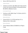
Definitely would probably be long but there wouldn't be a lot of mountains for him to drive around. But it's better than going to Atlanta then back up.This is the way

4.4M views · 42K reactions | Boone Mudslide | One of the most horrifying videos I’ve ever seen. A couple in Boone, NC, barely avoided a mudslide easily moving 60 mph near their home. | By Meteorologist James Scott WCCBFacebook
One of the most horrifying videos I’ve ever seen. A couple in Boone, NC, barely avoided a mudslide easily moving 60 mph near their home.
 www.facebook.com
GoDuke
Member
Has anyone seen any evidence of the national guard or fema or any kind of state or federal relief on the ground? Not saying they’re not there I just haven’t seen anything.
Shaggy
Member
Heard yesterday the coast guard had deployed for helicopter rescuesHas anyone seen any evidence of the national guard or fema or any kind of state or federal relief on the ground? Not saying they’re not there I just haven’t seen anything.
Tarheel17
Member
Has anyone seen any evidence of the national guard or fema or any kind of state or federal relief on the ground? Not saying they’re not there I just haven’t seen anything.

North Carolina's Weather Authority
The North Carolina National Guard has arrived in Spruce Pine, another community in dire need of help. There are so many folks there, really. Photo via: Jocelyn Graham
 www.facebook.com
Was driving on 85 from Charlotte -> RDU today and saw state emergency mgt assets (looked like a mobile hospital) going the other way.
Sctvman
Member
I saw a tweet from the TN National Guard deploying Black Hawks to the affected areas.Has anyone seen any evidence of the national guard or fema or any kind of state or federal relief on the ground? Not saying they’re not there I just haven’t seen anything.
Showmeyourtds
Member
Interesting weekend to say the least. Decided to move forward with my plans to take my wife & toddler up to meet my parents, brother, sister in law & sister to celebrate my dad's 70th birthday in the mountains. Your old man only turns 70 once, so I said what the hell, the storm was supposed to pass along or just west of where my home is- It'll be wet up there, but the weekend should be alright. Folks came from Birmingham, brother & sis drove down from Nashville via I-40
We stayed at a mountain home in Sapphire, NC.
The drive up on Thursday evening from Holly Springs was wet, which was to be expected. Woke up on Friday morning to trees swirling around and crashing all over the place. Oh yeah, the power was out too. Thankfully the home we were renting was unharmed. Can't say the same for others in the development.
To make matters worse, all forms of communication were cut off. There wasn't anywhere to get information or anyway to get information other than searching for a radio station or speaking with someone face to face.
Thankfully, it was safe enough for us to get down the mountain a bit to hwy 64. We located a police station just a few miles down the road toward Cashiers and stopped by to see what they could share with us.
Apparently, we weren't supposed to be there, as there was a mandatory evacuation order for Jackson county. Had we received that notice, we certainly would've left- But that's kind of hard when communication is completely gone.
We learned a short time later that hwy 64 was washed out 2 miles to our east and a landslide occurred 3 miles to the west leaving us completely cut off without any way to notify anyone that we were okay.
We then returned to our rental home & tried to see if we can get any information via radio. I was somehow able to pick up WSB loud & clear from my vehicle. My sister-in-law found a station out of Ashville in her car where we started to understand how much of an impact this storm had. We talked to an individual who lived in the same development where our rental home was. He shared the news about what had occurred to the East near Chimney Rock & Lake Lure.
He also said that the town of Highlands, where we had dinner reservations that evening, had been cut off as well.
We went back down to the police station a few hours later & learned that the road had been cleared and also that the Ingles in Cashiers was open on generator power.
We trudged over to grab ice, batteries & more booze. The road was passable, but was littered with debris. Widespread flooding on the golf courses & hundreds of snapped trees dangling precariously over utility wires.
Come to find out that it's cash only because the point of sale system can't operate due to the communications being wiped out, so we put the batteries and ice back.
In talking to folks at the grocery store, some of whom had come from Highlands, they said that the town hall had power but also had managed to get some limited form of Internet up & running so folks could contact people to let them know that they're okay.
Our power finally returned on Friday afternoon.
We worked our way through some of the thickest fog I've ever encountered on Saturday and were able to connect with our family members at the Highlands town hall.
We ventured out this morning & found a small coffee shop in Cashiers that had Internet. We learned that hwy 107 was passible between Cashiers and Walhalla....it was treacherous, but it was passible. We were able to make it out of there today via this route.
Y'all, the amount of infrastructure damage that was visible on hwy 107 between Cashiers and Walhalla is unreal, especially at the ridgelines. It will take weeks to get all of this repaired, if not longer to get communications restored - and from what I've been able to learn, this area wasn't necessarily the worst hit.
If you know any linemen or anyone who works for an electric cooperative in that area, buy 'em a round & give 'em a hug. They've got some long shifts ahead of them.

Went to help in the Lake Lure/Chimney Rock area today, and it’s hard to describe - never seen anything like this. Post apocalyptic. It’s so overwhelming... | By Tariq | Facebook
Went to help in the Lake Lure/Chimney Rock area today, and it’s hard to describe - never seen anything like this. Post apocalyptic. It’s so overwhelming...
 www.facebook.com
Sctvman
Member
GoDuke
Member
Sctvman
Member
So Far from what Ive gathered. The towns of
Spruce Pine,Marshall,Chimney Rock Are gone wiped out. Those are noteworthy towns on any map, few 1000 plus population each town. No clue how many Communities have been wiped out.
Spruce Pine,Marshall,Chimney Rock Are gone wiped out. Those are noteworthy towns on any map, few 1000 plus population each town. No clue how many Communities have been wiped out.
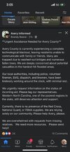
Avery County is dear to me from spending much time there through the years. I certainly hope the calls for help are going to be answered.
Henry2326
Member
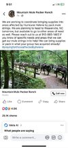
Switzerland Cafe and General Store in New Switzerland, NC posed of Facebook 9 hours ago:
Update: National Guard arrived late last night. Clearing parkway between LS & Gillespie Gap.
We are staging a central distribution location for LS downtown as soon as skies clear enough to get small planes in. Stay tuned to this page for day & time. We will have food to give away, water and people are welcome to bring food for distribution.
Henry2326
Member
Henry2326
Member
Henry2326
Member
Brent
Member
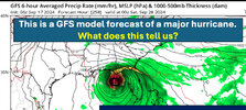
Kinda wild how accurate this one GFS run from more than 10 days out ended up being. Other than being a day too late View attachment 152356
Yeah I know there a lot of talk about Atlanta but this was a very good forecast otherwise... Even the intensity forecast was better than usual. It was not a surprise that it blew up like it did(many storms have been before...). Landfall point in Florida was maybe 50 miles off at most
Just sucks so many people died and are missing
And like I said on Thursday I don't know how much better NC would have fared even if it had hit Atlanta. Some of the flooding started before Helene
Last edited:
Absolutely. The flooding threat was very well forecasted by WPC days in advance. There’s some good discourse going on over on Twitter currently regarding how we can get more specific and impactful information out during flood warnings. Directly to phones, etc… Potential graphics showing likely areas to flood so that folks can understand the gravity of the situation. Not sure it would’ve helped much here specifically…Yeah I know there a lot of talk about Atlanta but this was a very good forecast otherwise... Even the intensity forecast was better than usual. It was not a surprise that it blew up like it did. Landfall point in Florida was maybe 50 miles off at most
Just sucks so many people died and are missing
And like I said on Thursday I don't know how much better NC would have fared even if it had hit Atlanta. Some of the flooding started before Helene
Just a perfect set up of horrible factors. The PRE event, the storms intensity, the size, the speed it moved inland causing the wind damage. It will be quite awhile before there is a more impactful hurricane IMO.
For me personally, I spent the first 12 hours or so after upset/confused about the Atlanta miss and wondering why that was so poorly forecasted. But once I saw images coming out of those areas that were affected, that quickly shifted to gratitude and being thankful that we were spared. Sobering to see the real images and stories coming out and puts things in perspective quickly.
My heart and prayers are with all who experienced damage and loss during this.
- Status
- Not open for further replies.


