Sorry to hear that, power flickered a few time here and never lost cell service just a few miles east of you!Well I’m back on here after a long day. My power is still out but cell service has finally been restored to my area. Ended up with only 4.13” of rain… I say only after finally seeing some of the heartbreaking pictures to the west.
-
Hello, please take a minute to check out our awesome content, contributed by the wonderful members of our community. We hope you'll add your own thoughts and opinions by making a free account!
You are using an out of date browser. It may not display this or other websites correctly.
You should upgrade or use an alternative browser.
You should upgrade or use an alternative browser.
Tropical Major Hurricane Helene
- Thread starter SD
- Start date
- Status
- Not open for further replies.
Any explanation from the NHC on their track and how far off they were yet?
Psalm 148:8
Member
- Joined
- Dec 25, 2016
- Messages
- 345
- Reaction score
- 792
I really want to know this! However, in the past I have heard.. storms this big and this strong can create their own environment! Pretty sure she did!Any explanation from the NHC on their track and how far off they were yet?
Drizzle Snizzle
Member
Maybe the fact it was stronger pulled it east and the NHC was not expecting it to be so strong ?
SuperNET
Member
What a terrible weather event - simply put. Having lived in the mountains (Black Mountain, NC) and working in the mountains for 20+ years - I feel a lot of sorrow and a sense of helplessness. I have called as many folks as I could on Wed/Thu - to not only let them know there could be potential flooding but to extend well wishes and to be safe. Some of the pictures and videos are difficult to look at - these are my people - and the towns that I hung out in are severely damaged. This wont be fixed in a day or a week, maybe a month or 2 - and in some cases this is permanent damage. I know the state has all hands on deck and staging people to go in and help (Feds too) - and that makes me feel a little better - but it does not take away the complete sadness that I have for my mountain peoples.
Sctvman
Member
Apparently Savannah still doesn’t have any power. So far away from the storm but hurricane force gusts there
I just can't fathom what has happened in the mountains of NC. I went to App and I used to have family in Hendersonville that I visited every year when I was a kid, so it hits a little close for me.
NCHighCountryWX
Member
- Joined
- Dec 28, 2016
- Messages
- 700
- Reaction score
- 1,921

CltNative90
Member
Seeing pictures of areas
Below is a picture of downtown Spruce Pine taken yesterday and posted on Facebook. Water all the way up to awnings. Unfortunately these areas will likely be lower priority than Asheville and some of the other larger towns.

Hearing horrible heartbreaking stories from folks with loved ones up in Mitchell and Yancey Counties. Those areas are currently cut off from society with no cell service. Scrolling through Facebook posts some are saying the area is now unrecognizable. This is an area of the mountains I’ve vacationed to at least once a year, sometimes multiple times a year, since my childhood. I don’t personally have friends up there, but many acquaintances and they are some of the friendliest people you could ever meet.I just can't fathom what has happened in the mountains of NC. I went to App and I used to have family in Hendersonville that I visited every year when I was a kid, so it hits a little close for me.
Below is a picture of downtown Spruce Pine taken yesterday and posted on Facebook. Water all the way up to awnings. Unfortunately these areas will likely be lower priority than Asheville and some of the other larger towns.
- Joined
- Jan 23, 2021
- Messages
- 4,604
- Reaction score
- 15,202
- Location
- Lebanon Township, Durham County NC
Verizon is listing services as limited from the state line to basically 321.
Dunkman
Member
I can get through to my sister in Old Fort (decimated, they’ve been told to leave town) on Verizon but not my brother in Fletcher on T-Mobile.Verizon is listing services as limited from the state line to basically 321.
- Joined
- Jan 23, 2021
- Messages
- 4,604
- Reaction score
- 15,202
- Location
- Lebanon Township, Durham County NC
I dont know how many bodies they are going to find when the water recedes but i'm afraid its gonna be more than a few.
Henry2326
Member
Doubtful.....frankly, they ignored an entire subset of data from Euro, GFS, ICON, and even CMC, as well as Hwrf and Hmon. I watched it, as well as most of us, for days telling them the opposite. They ignored it and left people vulnerable.Maybe the fact it was stronger pulled it east and the NHC was not expecting it to be so strong ?
Snow_chaser
Member
Definitely not sticking up for them, but didn’t they local NWS warn people about the flooding potential?Doubtful.....frankly, they ignored an entire subset of data from Euro, GFS, ICON, and even CMC, as well as Hwrf and Hmon. I watched it, as well as most of us, for days telling them the opposite. They ignored it and left people vulnerable.
- Joined
- Jan 23, 2021
- Messages
- 4,604
- Reaction score
- 15,202
- Location
- Lebanon Township, Durham County NC
If you go back and look at the short range models going back to Wednesday, you could've drawn that map. Amazing consistency and verification
1000%. HRRR nailed thisIf you go back and look at the short range models going back to Wednesday, you could've drawn that map. Amazing consistency and verification
Brent
Member

NCHighCountryWX
Member
- Joined
- Dec 28, 2016
- Messages
- 700
- Reaction score
- 1,921


Helping my in-laws today. Long road to recovery for them 
Drizzle Snizzle
Member
It’s almost like there was very little wind even just a few miles west of the center.
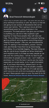
Not trying to light up NWS Peachtree city. I know they were handcuffed from the consistently west forecast. But this is such a brutal wind map compared to what happened. Parts of Southeast GA shaded in yellow got 80-90mph winds gusts
This was the final call map they essential put out on Friday afternoon for wind gusts

This was the final call map they essential put out on Friday afternoon for wind gusts
Last edited:
NCHighCountryWX
Member
- Joined
- Dec 28, 2016
- Messages
- 700
- Reaction score
- 1,921

Drizzle Snizzle
Member
I seriously doubt Southwest Georgia from Albany to the FL border got over 110 mph winds as this map suggests.Not trying to light up NWS Peachtree city. I know they were handcuffed from the consistently west forecast. But this is such a brutal wind map compared to what happened. Parts of Southeast GA shaded in yellow got 80-90mph winds gusts
View attachment 152282
GarnerNC
Member
Has anyone heard anything out of West Jefferson? Feel like I haven't read anything from up that way.
Sorry I should’ve clarified. This was the forecast wind gust potential they put out Friday afternoon . I will edit my post now to avoid confusion. This was their final call essentiallyI seriously doubt Southwest Georgia from Albany to the FL border got over 110 mph winds as this map suggests.
I'm not bashing the NHC even though they dropped the ball. It was probably because if their models were somehow correct and a city the size of Atlanta took the brunt when they called for it to be east, there would have been hell to pay. It still sucks for us east. Posters saying that the ones east knew what was coming anyway is simply not true. Yes, we knew the east side is the worst and effects travel outside the cone and there would be wind and severe weather. But where the center goes is still very important. If their forecast was correct we would have gotten what the east side of Columbia up through the east side of Charlotte got. Which was a little wind and some power outages but for the most part life would have been back to normal today. That is far from the case now. That power outages map tell it all and that would have been 75-100 miles west had the NHC been correct.
Drizzle Snizzle
Member
but Friday afternoon was well after it made landfall right ? I think landfall was Thursday nightSorry I should’ve clarified. This was the forecast wind gust potential they put out Friday afternoon . I will edit my post now to avoid confusion. This was their final call essentially
Sorry got my days mixed up. Been a long week. Yes this was put out Thursday afternoon as the storm was about to make landfallbut Friday afternoon was well after it made landfall right ? I think landfall was Thursday night
Fountainguy97
Member
Hey guys.. we are dealing with a mass casualty event here in Erwin. 39 people missing. None accounted for. I'm sure there are many many more.
Police estimate the water topped 30ft beating the 1977 record by 6+ feet. I've had people calling me asking if I've heard from people.
I've never experienced anything like this.
The damage isn't even close to being fully realized yet. There are caskets flowing down the river. Reports of some rescuers finding bodies being found in trees 15feet up..
Brent
Member
I'm scared of what has happened in the mountains. Camille killed over 100 people in the mountains
Strength was not the issue. The strength of the storm was well known before landfall.Maybe the fact it was stronger pulled it east and the NHC was not expecting it to be so strong ?
NCHighCountryWX
Member
- Joined
- Dec 28, 2016
- Messages
- 700
- Reaction score
- 1,921
Send a text message via satellite on iPhone
Send a text message via satellite on iPhone when you’re offline.
support.apple.com
kennedybb6
Member
Wow just got a chance to read and catch up I am here whining about no power for two days now and these folks have lost everything if you guys have any local charities that I can donate to please post !
Praying for the best for the people there and also the front line workers who are doing everything possible to help
Praying for the best for the people there and also the front line workers who are doing everything possible to help
Downeastnc
Member
Geez almost became a statistic...
JP152
Member
I fear there will be many many more deaths. This is the Carolina's/Tennessee's version of Hurricane Camille. Nelson County Virginia received up to 30 inches of rain in just 5 hours. There is simply not much you can do to keep safe during these catastrophic events.
NCHighCountryWX
Member
- Joined
- Dec 28, 2016
- Messages
- 700
- Reaction score
- 1,921

How’s Watauga county? Specifically Deep Gap
Anybody heard from our poster in Erwin, TN?
- Status
- Not open for further replies.