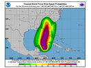
This is Ground Zero-B for major destruction. Ground Zero-A is the coastal Counties at landfall, But SW NC/North Ga Mountains are gonna get their worst hit in my lifetime from a Tropical entity. a Foot plus of Rain over 24 hr period in that terrain will turn catastrophic. There are like 19 peaks in the Smoky Mtns at or above (barely) 6,000 feet.16-20 for the southern escarpment. That’s not good.
-
Hello, please take a minute to check out our awesome content, contributed by the wonderful members of our community. We hope you'll add your own thoughts and opinions by making a free account!
You are using an out of date browser. It may not display this or other websites correctly.
You should upgrade or use an alternative browser.
You should upgrade or use an alternative browser.
Tropical Major Hurricane Helene
- Thread starter SD
- Start date
- Status
- Not open for further replies.
6Z EMCF has some large population areas in its path. A tick west of 00z too.
Tallahassee to Macon to Atlanta. Yikes.
Tallahassee to Macon to Atlanta. Yikes.
HugeSnowStick
Member
I agree with you somewhat, but you are discarding the massive Atlanta metro, 7.5 million, this could be ground Zero-B.This is Ground Zero-B for major destruction. Ground Zero-A is the coastal Counties at landfall, But SW NC/North Ga Mountains are gonna get their worst hit in my lifetime from a Tropical entity. a Foot plus of Rain over 24 hr period in that terrain will turn catastrophic. There are like 19 peaks in the Smoky Mtns at or above (barely) 6,000 feet.
ForsythSnow
Moderator
There hasn't been a loss in deep convection improvements since it started last night. Definitely need to watch for RI when it clears the Yucatan if it persists.
jaymackd3
Member
Man, the first wide area visible presentation of this massive storm is awe-inspiring and concerning at the same time.
jaymackd3
Member
HugeSnowStick
Member
Typical, I get weenies and foolishness. This could damage major infrastructure; The mountains are basically sparsely populated.I agree with you somewhat, but you are discarding the massive Atlanta metro, 7.5 million, this could be ground Zero-B.
jaymackd3
Member
sure looks like the center is making landfall
- Joined
- Jan 23, 2021
- Messages
- 4,577
- Reaction score
- 15,106
- Location
- Lebanon Township, Durham County NC
Atlanta is on the NW side of most of the model guidance. You know how this works, right? The NW side is the side you want to be on. I'm not saying that Atlanta wont have any issues but I dont think they are currently facing what East Georgia/NW SC/WNC are going to face. That isnt even to mention the orographic lift and enhancement of wind that'll come with terrain.Typical, I get weenies and foolishness. This could damage major infrastructure; The mountains are basically sparsely populated.
Drizzle Snizzle
Member
doesn't the NHC have the center going directly over Atlanta ?Atlanta is on the NW side of most of the model guidance. You know how this works, right? The NW side is the side you want to be on. I'm not saying that Atlanta wont have any issues but I dont think they are currently facing what East Georgia/NW SC/WNC are going to face. That isnt even to mention the orographic lift and enhancement of wind that'll come with terrain.
rburrel2
Member
South and east facing slopes will double the rainfall totals of Atlanta area. Plus the fact that terrain promotes mudslides and the higher elevation pokes into to the stronger elevated wind field. The mountains will be ground zero outside of the immediate coast.
itryatmanysportsespgolf70
Member
Hello everyone. This may have been mentioned, but the nam isn't giving up yet on Helene being sub 900mb
Snow_chaser
Member
Looks to me on the latest runs it either right over Atlanta or a tad west of Atlanta, but as it’s been said, the size of this thing the impact will be wide spreaddoesn't the NHC have the center going directly over Atlanta ?
WEATHERBOYROY
Member
Looking at Cancun radar it appears that the lower part of the storm is off shore and moving away now from Mexico. The SWquadrant looks to be intensifying!sure looks like the center is making landfall
iGRXY
Member
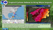
The center has only shifted slightly to the west. Impacts are staying the same becaus of the size. GSP has updated since CAE posted this and it's still looking like this.What is this? NWS CAE attaches contradictory images on the same post. They call for 1.5-2 inches in the same areas where NOAA calls for 4-6 in the same post. It's clear the models are shifting west and that's why the totals are dropping and the low amounts will probably verify. But that's a very contradictory post
View attachment 151740
jaymackd3
Member
Thank you for that clarification! Sure is deceiving on satellite. Guess it was a flare up.Looking at Cancun radar it appears that the lower part of the storm is off shore and moving away now from Mexico. The SWquadrant looks to be intensifying!
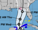
Center via recon is off shore and I would imagine we start to see a more northerly motion. I think it’s cleared for takeoff now.
Henry2326
Member
HWRF and HMON have it just offshore.....but it never makes it on land and maintains pressure.sure looks like the center is making landfall
WEATHERBOYROY
Member
HWRF and HMON have it just offshore.....but it never makes it on land and maintains pressure.
It probably isn't aligned vertically. the satellite is seeing the cloud top and the radar is seeing the ground returns.Thank you for that clarification! Sure is deceiving on satellite. Guess it was a flare up.
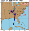
Pasta is locked in.
View attachment 151753
If that western creep continues, it’s gonna end up right over my head.
Wont be a bad here as to the east though.
jaymackd3
Member
NoSnowATL
Member
Nerman
Member
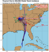
That doesn't jive with this though. It will be interesting to watch it unfold. I don't have a dog in the fight. I'm NE of Atl & my family is NW of Atl. We're just getting ready to hunker down.Atlanta is on the NW side of most of the model guidance. You know how this works, right? The NW side is the side you want to be on. I'm not saying that Atlanta wont have any issues but I dont think they are currently facing what East Georgia/NW SC/WNC are going to face. That isnt even to mention the orographic lift and enhancement of wind that'll come with terrain.
Georgiapeach
Member
SnowwxAtl
Member
Which one is the mean plot?That doesn't jive with this though. It will be interesting to watch it unfold. I don't have a dog in the fight. I'm NE of Atl & my family is NW of Atl. We're just getting ready to hunker down.
View attachment 151757
Mahomeless
Member
Almost completely out of the Big Bend area now, with numerous members riding the AL/GA border.....so much for nice weather around here. The SW portions of the mountains in NC is in for torrential rains with upslope enhancements, as well as a buzzcut on trees above 5,000 ft. Praying for you guys that live up that way....its going to be rough.Pasta is locked in.
View attachment 151753
RollTide18
Member
Pasta is locked in.
View attachment 151753
Dothan and Columbus could in for a rough time
NoSnowJoe
Member
Spann is hanging with the east movement, putting most of the storm on the east side of the state.
Snow_chaser
Member
Which makes sense since he’s in Alabama, I’d think there’d be no way it could go far enough west for middle of Alabama to be on east side
SnowwxAtl
Member
A slight east jog from 06z . Still no big changes to the impact from Helene (and won't be). View attachment 1000009892.jpg
From Matthew East this morning.
As of 8am Wednesday, #Helene has that 'look' of a rapidly intensifying system. It is an upper end tropical storm as of the 8am advisory, and will soon become a hurricane.
As of 8am Wednesday, #Helene has that 'look' of a rapidly intensifying system. It is an upper end tropical storm as of the 8am advisory, and will soon become a hurricane.
Spann is hanging with the east movement, putting most of the storm on the east side of the state.
That ain’t good for Alabama…
BufordWX
Member
Appreciate you understanding my post. Im not trying to down play, have a contest with heavy metro areas or any location. Im talking property damage, from MAJOR, MAJOR Flash Flooding. It will wash out roads and bridges galore in SW NC. Folks have no idea how much more destructive flash flooding is in that area. 95% folks live, towns located on valley floors at 1800- 2300 feet. But all around them are 4000- 6000ft Peaks. All that rain comes downhill into those valleys lightening fast , on top of what they are receiving straight from the sky. They will max out on total storm qpf,just from the metorology of upslope up the escarpment etc. My post has nothing to do with Money cost as a Metric. Its simply being logistically impaired well after the storm. Tree falls on a car, you file insurance,go get another, move on with life. But when your community looses roads, water treatment plants etc, the problem doesnt disappear the next day and affects everyone for weeks.Atlanta is on the NW side of most of the model guidance. You know how this works, right? The NW side is the side you want to be on. I'm not saying that Atlanta wont have any issues but I dont think they are currently facing what East Georgia/NW SC/WNC are going to face. That isnt even to mention the orographic lift and enhancement of wind that'll come with terrain.
Makeitsnow
Member
At this point it's all but certain imo areas east of a line from dawsonville to Lawrenceville to Forsyth will see the strongest impacts windwise...subject to any east shifts which doesn't look likely right now. The only real question in my mind is will Atlanta. Models show the worst of the wind to the right of the track but the northern eyewall will be no joke either. So only a slight west shift puts Atlanta innthe worst of it. I'm also concerned about local topographical effects..along the 85 corridor/northward due the unusual northward movement....as the windfield will be compressed between the low.center and the mountains. Some of the higher res models have hinted at this. For my local it looks rather grim...for example the wrf showing well over 100knot 850mb winds here is concerning to say the least. The only good news is this thing will be moving so fast the high winds will not last long.That doesn't jive with this though. It will be interesting to watch it unfold. I don't have a dog in the fight. I'm NE of Atl & my family is NW of Atl. We're just getting ready t
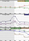
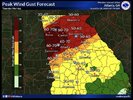
Sheesh. That’s so unprecedented. Looks like Atlanta is 50-60mphI was looking at the NWS forecast grid for my area and they are forecasting some massive gusts at the peak of the storm.
Snowflowxxl
Member
- Status
- Not open for further replies.

