There's no way this system maintains a CAT 3 (or even 2) as far up as ATL. I mean, if that DID happen it would be really bad esp for folks west of ATL (assuming the tracks even remain as they are - a lot is up in the air with Yucatan partial or full landfall)
-
Hello, please take a minute to check out our awesome content, contributed by the wonderful members of our community. We hope you'll add your own thoughts and opinions by making a free account!
You are using an out of date browser. It may not display this or other websites correctly.
You should upgrade or use an alternative browser.
You should upgrade or use an alternative browser.
Tropical Major Hurricane Helene
- Thread starter SD
- Start date
- Status
- Not open for further replies.
There's no way this system maintains a CAT 3 (or even 2) as far up as ATL. I mean, if that DID happen it would be really bad esp for folks west of ATL (assuming the tracks even remain as they are - a lot is up in the air with Yucatan partial or full landfall)
I don’t think he/she means that. I think he/she means landfall strength. Cat 3 anywhere near that far inland? No way. Also the case for cat 2 I’d think.
BufordWX
Member
Brent
Member
I don’t think he/she means that. I think he/she means landfall strength. Cat 3 anywhere near that far inland? No way. Also the case for cat 2 I’d think.
Yeah there's no way this will be a significant hurricane still in Atlanta but widespread 60-70 mph winds for a few hours are gonna cause a lot of issues. I don't think people realize how bad even those winds can be. That will put down hundreds of trees in Atlanta. That's pretty much what Opal was. I think that's pretty much the assumption of what happens here barring something really crazy. It's gonna be hard to get at least widespread winds stronger than that that far inland
Makeitsnow
Member
I was referring to landfall strength. Obviously there will be significant weakening of sustained surface winds after landfall..but across the board the models are showing high boundary layer winds..indeed they aren't showing much weakening at all until the mountains. Which means high gust potential.There's no way this system maintains a CAT 3 (or even 2) as far up as ATL. I mean, if that DID happen it would be really bad esp for folks west of ATL (assuming the tracks even remain as they are - a lot is up in the air with Yucatan partial or full landfall)
The winds will be felt well outside the center of the storm. A Cat 4 or 5 (unlikely) hitting FL would destroy ATL, and a lot of others with wind due to the forward speed and size.
Brent
Member
The winds will be felt well outside the center of the storm. A Cat 4 or 5 (unlikely) hitting FL would destroy ATL, and a lot of others with wind due to the forward speed and size.
I mean yeah if this turns into Michael then the storyline may change but well it's naked right now and sheared... Until the storyline changes we need to take a deep breath
i would think because of the trough it's getting absorbed into, there's going to be a slight baroclinic element that will preserve low pressures well inland
Thank you. Anyone hoping this thing reaches major status and stronger is bat-**** nsanei would think because of the trough it's getting absorbed into, there's going to be a slight baroclinic element that will preserve low pressures well inland
severestorm
Member
Cat 2 in atlanta is a pipe dream and probably physically impossible. I hope nobody is hoping that. however i'm still pretty bullish on the strenght; and if it continues to get its ducks in a row with the structure and establishing a cdo this will make a run at a 4Thank you. Anyone hoping this thing reaches major status and stronger is bat-**** nsane
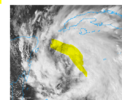
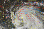
Looking at the visible satellite loop currently, it seems that the exposed center is ever so slowly getting some convection surrounding it. Also looks to be moving back to the NW to NNW as opposed to its ejection earlier today.
Drscottsmith
Member
I have an anemometer printout from Hugo from 34.233244, -80.659689 with 4 wind gusts >110mph (off the scale of the meter).There's no way this system maintains a CAT 3 (or even 2) as far up as ATL. I mean, if that DID happen it would be really bad esp for folks west of ATL (assuming the tracks even remain as they are - a lot is up in the air with Yucatan partial or full landfall)
That coordinate is in Lugoff, SC about 122 miles from McClellanville, SC where Hugo made landfall.
She's gonna be a big one.
A quote from the NOAA NWS National Hurricane Center.
“Helene's forecast radii are at the 90th percentile of hurricane size at similar latitudes.
Due to the forecast large size of this
system, storm surge, wind, and rainfall impacts will extend well away from the center, particularly on the east side.
In addition, the fast forward speed while it crosses the coast will likely result in farther inland penetration of strong winds over parts of the southeastern United States after landfall.”
I would expect that with the overall size of the storm that’s expected and the fast forward speed, there could be an exceptionally higher risk for tornadoes in the right front quadrantI’m extra worried that the tornado threat from this in especially the NE sector is going to be high. Is that true? Any thoughts? I haven’t heard much about that yet.
ForsythSnow
Moderator
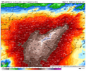
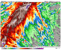
Not sure I'd it's just me but I think this plus Helene is going to rival 2009's flooding if the totals truly reach those levels.18z 3K NAM rain totals. This is all BEFORE the system makes landfall so this is solely from the PRE
Models are locking in on a significant rainfall event in North Georgia View attachment 151651
Drizzle Snizzle
Member
And can you imagine if we get another tropical system in October on top of all of this rain ?Not sure I'd it's just me but I think this plus Helene is going to rival 2009's flooding if the totals truly reach those levels.
Ron Burgundy
Member
Was just thinking the same. There were things flooding in my area that day that I never even knew existed.Not sure I'd it's just me but I think this plus Helene is going to rival 2009's flooding if the totals truly reach those levels.
- Joined
- Jan 5, 2017
- Messages
- 3,779
- Reaction score
- 5,989
I hope not. The ground is very dry and the antecedent rainfall will hopefully help prime it for uptake of the moderate to heavy precipitation rates that follow.Not sure I'd it's just me but I think this plus Helene is going to rival 2009's flooding if the totals truly reach those levels.
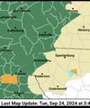
Don't know if it was posted but GA now under a state of emergency
https://www.atlantanewsfirst.com/20...ared-georgia-ahead-helene-gov-kemp-announces/
https://www.atlantanewsfirst.com/20...ared-georgia-ahead-helene-gov-kemp-announces/
If the storm is moving so fast; what would cause so much rain ?
Ron Burgundy
Member
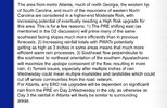
FFC is buying into the PRE for tomorrow. Link to the full disco at bottom:
The biggest thing to note compared to the
previous forecast is increasing confidence on heavy rainfall leading
to flash flooding across much of North GA including the ATL metro
tomorrow (Wednesday) afternoon. Tropical moisture will be on the
increase and will set up ahead of the frontal boundary moving in
from the northwest. Thus, PWs will be upwards of 2+ inches per
latest guidances. An upgrade (from WPC) will be forthcoming for
northeast GA down south including Metro ATL for a Moderate Risk (3
out of 4) of Excessive Rainfall -- i.e. the greatest risk for
rainfall intense enough to cause flash flooding. Latest forecast
totals (for Wednesday only) ranges from 2 to 3 inches with locally
higher amounts. Heavy rainfall and flash flooding potential will be
the main concern for tomorrow (Wednesday) -- note: this is ahead of
anything tropical related. As a result of increasing confidence in
hydro related issues, we have opted to issue a Flood Watch for much
of North and Central GA. This will encompass the threat for
Wednesday and then the evolving threat for the Thursday-Friday
timeframe in association with Tropical Storm Helene. For details
about Tropical Storm Helene please see the long term discussion
below.
FFC Afternoon Disco
GeorgiaGirl
Member
If the storm is moving so fast; what would cause so much rain ?
Well, there may be a significant pre event in North Georgia tomorrow.
Stormsfury
Member
The larger LLC swirl is drifting back north or just west of due north trying to rejoin the convective blob party with some hints of towers going up it.
the tropical moisture envelope extends well past helene. take that rich airmass and have it get ingested into the forcing ahead of a sharp trough- really efficient way to create heavy rain. i totally buy the qpf forecastsIf the storm is moving so fast; what would cause so much rain ?
Sheesh
My God, at the training over N. Georgia.
What’s causing that setup?My God, at the training over N. Georgia.
ForsythSnow
Moderator
The perfect feed between the upper level low and Helene. It's going to get very wet here tomorrow onward. A widespread 6 to 8 inches is going to cause a lot of issues.What’s causing that setup?
Looks like 2009 or Dennis in 05 to me.My God, at the training over N. Georgia.
For anyone wanting some afternoon reading on PRE here’s a 2010 paper from CSU
Snow_chaser
Member
And like what’s been mentioned before, there’s parts of NW Georgia that hasn’t had any significant rain in a long time. This come down hard and fast it’s all going to run off causing floodingMy God, at the training over N. Georgia.
- Status
- Not open for further replies.

