thanksgivingbrown
Member
I don’t see anything official yetWe have Helene
I don’t see anything official yetWe have Helene
Should be about 10:00 or 11:00I don’t see anything official yet
I don’t see anything official yet


Just about the same as 06z no major difference
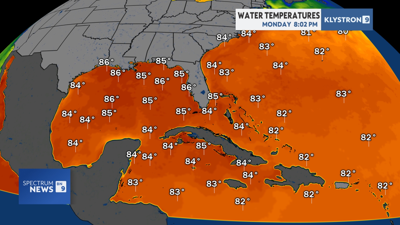
it looks fine enough but that llc is still murky to me and pressures will only gradually drop until there's some more definition.
Might help if you elaborate on that recon data, some on here aren't going to understand it, heck I could use a refresher myself from time to time. Where'd you find it and what they indicate, might help others understand why this will most likely be Helene at next updateAL, 09, 2024092412, , BEST, 0, 194N, 837W, 40, 1000, D.
OkMight help if you elaborate on that recon data, some on here aren't going to understand it, heck I could use a refresher myself from time to time. Where'd you find it and what they indicate, might help others understand why this will most likely be Helene at next update

All 4 hurricane models are on the far east side of the track.Just about the same as 06z no major difference


Finally someone is saying it out loud.Some strong wording here by Chris Justus.
View attachment 151628
What did he say, it is cut in half..???Finally someone is saying it out loud.
Honestly 3k NAM TC discussion/images belongs in banter. It's 100% useless lol3k NAM is doing 3k NAM things
It was cropped simply to highlight he was warning to prepare for a high impact storm.What did he say, it is cut in half..???


this is really important. i don't know how many of you sickos have a permanent tab on the vis open like i do but this thing just ejected an LLC from the central dense overcast. It's still very mushy at the surface and i don't really want to make any sweeping statements until that whole deal is figured out"The track guidance is very tightly
clustered, which would normally imply high forecast confidence.
However, depending on exactly where the center forms could end up
shifting the entire guidance suite in future cycles, so it is
imperative to not focus on specific landfall locations this far in
the future."
Just going over the Recon data looks like it shows two or three different little spins that they found so nothing definitive yet for surethis is really important. i don't know how many of you sickos have a permanent tab on the vis open like i do but this thing just ejected an LLC from the central dense overcast. It's still very mushy at the surface and i don't really want to make any sweeping statements until that whole deal is figured out
LOL, visible loop has been refreshed every five minutes since sunrise.this is really important. i don't know how many of you sickos have a permanent tab on the vis open like i do but this thing just ejected an LLC from the central dense overcast. It's still very mushy at the surface and i don't really want to make any sweeping statements until that whole deal is figured out

Have a feeling it'll rotate back around. The overall circulation envelope is massive. Seeing multiple small Eddies just whipping around her right now.this is really important. i don't know how many of you sickos have a permanent tab on the vis open like i do but this thing just ejected an LLC from the central dense overcast. It's still very mushy at the surface and i don't really want to make any sweeping statements until that whole deal is figured out
This is true. I think if you looked at the satellite pictures of Michael in its formation stages, you would think no way is that gonna be a category 5 hurricaneJust to jog everyone’s memory, but these big Caribbean gyre type storms are really messy every time in the formation stages.
Ugly, early is par for the course.
.png")