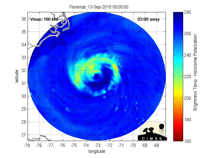
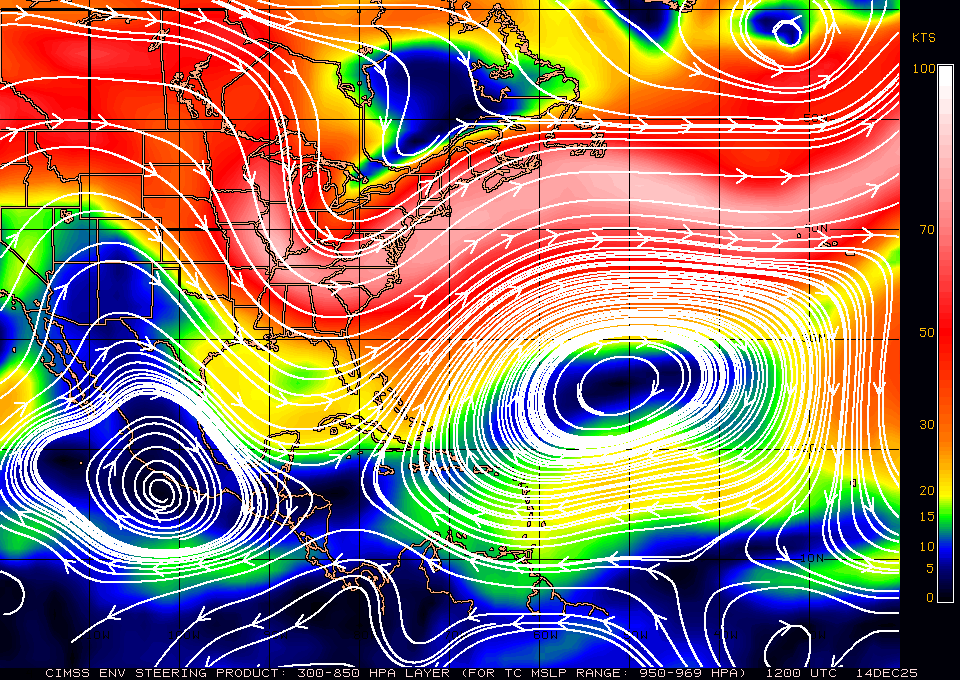
snowlover91
Member
Trying to find Topsail Island webcam. Anyone have any luck post the link.
Yeah it's done quite well surprisingly. I didn't think it would have done so well but it's good to know we have a model that can perform decently compared to the one its replacing.It's only been getting flack from people with an agenda or those who just weren't paying attention. The Euro has been mediocre with this storm, but because it went rogue numerous times it was just assumed it would "win" as if this is some kind of sports competition and these models aren't simply supposed to provide useful guidance for an actual forecaster to use to make a forecast, rather than regurgitate. The FV3-GFS has been a far more useful tool than the Euro with predicting this storm for me and my colleagues.
I am actually impressed with the GFS so far this storm. (*For the MOST part*). It did have some really dumb runs for sure, but its been doing a pretty good job in the short term, and kudos to it for showing the looping and stalling motion first.It's only been getting flack from people with an agenda or those who just weren't paying attention. The Euro has been mediocre with this storm, but because it went rogue numerous times it was just assumed it would "win" as if this is some kind of sports competition and these models aren't simply supposed to provide useful guidance for an actual forecaster to use to make a forecast, rather than regurgitate. The FV3-GFS has been a far more useful tool than the Euro with predicting this storm for me and my colleagues.
It is still supposed to at this point, BUT it has slowed waaaaaaay down...Pressure down 2 mb and still moving NW per recon. How is it moving NW?
If it stalls any bit earlier/longer then modeled over more general warm deeper water could definitely get interesting to watch forIt is still supposed to at this point, BUT it has slowed waaaaaaay down...
Here comes the tricky part now, we know its stalling, but where does it go from here. I still do think there is time for this to get a bit stronger.
Yeah the last part is what is slightly worrying. The decrease in speed plus the pressure drop and the better organization now makes me wonder if she is going to head up to cat 3 again.It is still supposed to at this point, BUT it has slowed waaaaaaay down...
Here comes the tricky part now, we know its stalling, but where does it go from here. I still do think there is time for this to get a bit stronger.
Looks like we are going to be getting hourly updates now as long as recon is flying around.NHC 10 am update puts the pressure at 955 mb.
I'm wondering that as well. Seems to me that they will be flying as many as they can now all the way up to landfall.Anymore flights planned to go into the storm at this point?
I know it's slowing down and it's probably more wnw then nw atm, also every model has this turning west into Wilmington. But looking at water vapor and current stirring currents don't be surprised if it slides a little more north more like Morehead City. There is a disconnect between the two highs and realize this is why the stirring currents are relaxing but nothing there either to really push this sw atm...
![]()
Damn![]()
Sent from my SM-G955U using Tapatalk
Already got a tornado warning
![]()
Sent from my iPhone using Tapatalk
Created an Observstions thread for posts like this just now. Since members will be directly impacted the thread needed to go up sometime.Yep seems quick....
Tornado Warning
Tornado Warning
NCC095-131515-
/O.NEW.KMHX.TO.W.0003.180913T1500Z-180913T1515Z/
BULLETIN - EAS ACTIVATION REQUESTED
Tornado Warning
National Weather Service Newport/Morehead City NC
1100 AM EDT THU SEP 13 2018
The National Weather Service in Newport has issued a
* Tornado Warning for...
Central Hyde County in eastern North Carolina...
* Until 1115 AM EDT.
* At 1100 AM EDT, a severe thunderstorm capable of producing a
tornado was located near Swindell Fork, or 27 miles north of Cedar
Island, moving west at 45 mph.
HAZARD...Tornado.
SOURCE...Radar indicated rotation.
I know the potential tornado is moving quickly, but I don't know if I've ever seen a Tornado Warning whose duration was only 15 minutes long.Yep seems quick....
Tornado Warning
Tornado Warning
NCC095-131515-
/O.NEW.KMHX.TO.W.0003.180913T1500Z-180913T1515Z/
BULLETIN - EAS ACTIVATION REQUESTED
Tornado Warning
National Weather Service Newport/Morehead City NC
1100 AM EDT THU SEP 13 2018
The National Weather Service in Newport has issued a
* Tornado Warning for...
Central Hyde County in eastern North Carolina...
* Until 1115 AM EDT.
* At 1100 AM EDT, a severe thunderstorm capable of producing a
tornado was located near Swindell Fork, or 27 miles north of Cedar
Island, moving west at 45 mph.
HAZARD...Tornado.
SOURCE...Radar indicated rotation.
Check your PM, looks like you were not included in the original PM about this the other day.... I just invited you so hopefully you can see that conversation. It was agreed to keep it all in hereCreated an Observstions thread for posts like this just now. Since members will be directly impacted the thread needed to go up sometime.