• Hello, please take a minute to check out our awesome content, contributed by the wonderful members of our community. We hope you'll add your own thoughts and opinions by making a free account!

Tropical Major Hurricane Florence

So, where does it go?
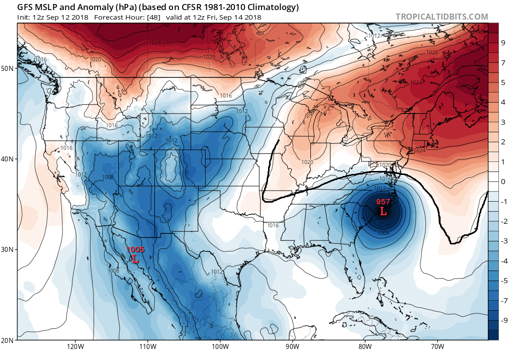
Go to the Tropical Tidbits site and play the loop. I don't know how to post it here. It goes wnw through the southern tier of NC (and then north through the foothills) after stalling near ILM.

It is much closer to what I have expected to happen. Could be wrong, I guess, but we'll see what the other models say.
 
The outer eyewall moat trying to develop w/ Florence is on the order of 125-150 miles in diameter (obviously it'll contract some from here), but my goodness this storm is big.
Did you see the NAM sim IR? It looks massive as it approaches land and is picture perfect.
 
The outer eyewall moat trying to develop w/ Florence is on the order of 125-150 miles in diameter (obviously it'll contract some from here), but my goodness this storm is big.

Any idea what might be causing it to try to form such a large eye? Usually most EWRC's I've seen don't form one this large... but I'm guessing this could also take a lot longer to complete too.
 
Any idea what might be causing it to try to form such a large eye? Usually most EWRC's I've seen don't form one this large... but I'm guessing this could also take a lot longer to complete too.

Good question! Ironically, I had a similar conversation w/ HM just a few hours ago, this might answer your question.

Screen Shot 2018-09-12 at 11.37.48 AM.png
 
One thing to keep in mind: the size of the storm and extent of tropical storm/hurricane force winds will likely exacerbate the storm surge potential, even if the maximum sustained winds are lower than they are now. Hurricane Ike was only a category 2 storm at landfall based on the maximum sustained winds (although that hurricane was larger in size than Florence currently), but it still produced a 22 foot storm surge.
 
WPC rainfall in the Carolinas, oof. Could easily see one foot+ totals just north of where the center tracks. Even though the WPC has the heaviest rains centered along US HWY 74 between Fayetteville & Charlotte that band could setup anywhere between the SC midlands and north-central NC.
wpc_acc_precip_northcarolina_168.png
 
By 48 GFS has landfall or close to it.
gfs_mslp_wind_seus_9.png
 
We're actually two different people.... Lol
Looking like the 12z crowd so far wants to bring it inland before stalling out now..... good grief

So far on the 12 models, they are pushing Florence further nw before stalling, which has major implications for the inland track
 
GFS at 60 is a decent bit west and inland from the 6z at 66.
 
So far the trend I've noticed on the 12z runs is a slightly faster motion for longer that gets Florence closer to the coast or just inland before the stall/drift occurs.
 
Broken record comment: I hope y'all got generators, water, etc.... prolonged TS/H force winds well inland spells prolonged power outages. And that is not fun
 
Looking like the 12z crowd so far wants to bring it inland before stalling out now..... good grief
Wouldn't this be better overall though? It would weaken the storm quicker than if it was stalled out over the water.
 
Wouldn't this be better overall though? It would weaken the storm quicker than if it was stalled out over the water.
I don't think so, no stall off shore allows it to make landfall as a stronger storm plus the inland effects will be much worse...
 
Anyone else think the wind field is going to explode in size at landfall to a size just smaller than Irma's? I'm thinking that because this storm keeps growing and it has a massive upper level wind field that has to go somewhere when it weakens.
 
92f729e2-4a6d-4187-96b0-d84bd577262c
From Hour 78 to 84 eyes moving SW it actually goes from Pressure drops from 988 to 966 so it's most likely holding strength
 
Back
Top