Snowflowxxl
Member
O. M. G.
O. M. G.
Assuming modeling is right as a whole, with just the stall out even, I'd expect Florence to be a retired name.

I remember they had to make a whole new set of colors for what Harvey did to the Houston area last year. I really hope she doesn't stall that long to produce that much rain. There's no way. Right?O. M. G.
I remember they had to make a whole new set of colors fot what Harvey did to the Houston area last year. I really hope she doesn't stall that long to produce that much rain. There's no way. Right?
.png")
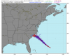
Where does it go after savannah
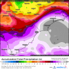
A lot for the coastal plain. Probably underdone inland but we'll see. Free/shareable full res Euro via: https://weather.us/model-charts/euro/791-w-341-n/acc-total-precipitation/20180918-1200z.htmlHow much rain did the euro show
What’s the euro mean
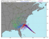
Very possible. New update (5AM) should be up very soon, so we shall see!Well thinking that NHC may very well expand some watch products south to near Darian Ga, just being prudent with the model trends. .. Thoughts?
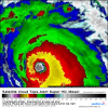
If we can get this ring of -70C cloud tops to close off and maintain itself around the eye, and if we can eliminate that dry air on the western side, whoever finds the core is gonna have some big time troubles down the line. Right on the cusp of taking it to the 'next level' IMO, we'll see if it actually happens. Link to where I got this image from: https://weather.us/satellite/692-w-301-n/top-alert-superhd-1min.html#play2

Some pretty wacky solutions mixed in here. Stall/loop or retrograde SW/onshore is the basic idea. But that could take a lot of different forms http://wx.graphics/models/eps_florence.png
Wow the 6z gfs just demolishes the SE coastline of NC
Yeah if it little further north before the stall and then heads almost due south before turning back West it definitely keeps it over water longer and although there will be upwelling the Gulfstream is out there soHmm a decent number of those ensembles have it staying off shore enough to strengthen. Even the Euro Op has weakening stopping.
Yeah if it little further north before the stall and then heads almost due south before turning back West it definitely keeps it over water longer and although there will be upwelling the Gulfstream is out there so
Sent from my SM-G920V using Tapatalk
Yeah if it little further north before the stall and then heads almost due south before turning back West it definitely keeps it over water longer and although there will be upwelling the Gulfstream is out there so
Sent from my SM-G920V using Tapatalk


How much is it showing and when does the heavy rain look to start? Sunday, for the western Carolinas!?6Z GFS is a disastrous track for WNC.
8+ inches. Sunday afternoon.How much is it showing and when does the heavy rain look to start? Sunday, for the western Carolinas!?

.png")