Sandbar
Member
You sure? lololol......It will be in Virginia tomorrow (j/k)The Inland threat for North Carolina is quickly diminishing in my opinion
Sent from my SM-G920V using Tapatalk
You sure? lololol......It will be in Virginia tomorrow (j/k)The Inland threat for North Carolina is quickly diminishing in my opinion
Sent from my SM-G920V using Tapatalk
It has diminished some, but even with the monkey business from the Euro, the weather.us wind gust maps still show 40-60 mph gusts for the Triangle. I don't know how accurate those charts are, though.The Inland threat for North Carolina is quickly diminishing in my opinion
Sent from my SM-G920V using Tapatalk
The Inland threat for North Carolina is quickly diminishing in my opinion
Sent from my SM-G920V using Tapatalk
The Inland threat for North Carolina is quickly diminishing in my opinion
Sent from my SM-G920V using Tapatalk
It has diminished some, but even with the monkey business from the Euro, the weather.us wind gust maps still show 40-60 mph gusts for the Triangle. I don't know how accurate those charts are, though.
It has diminished some, but even with the monkey business from the Euro, the weather.us wind gust maps still show 40-60 mph gusts for the Triangle. I don't know how accurate those charts are, though.
ya, I can't buy that either...thats a big WTF imoIt'll be interesting to see where the EPS goes. Obviously there is a good chance this slows or stops along the coast but a SSW drift along the SE coast from NC to Ga...hard to buy
Agree, and like I said a couple pages up, it would be a 1st for me, should it happen (and at my age, 1st's are seldom occurrences ... LOL)ya, I can't buy that either...thats a big WTF imo
When someone gets the EPS "mean" track map, please post it. All these lines are making me go crosseyed.
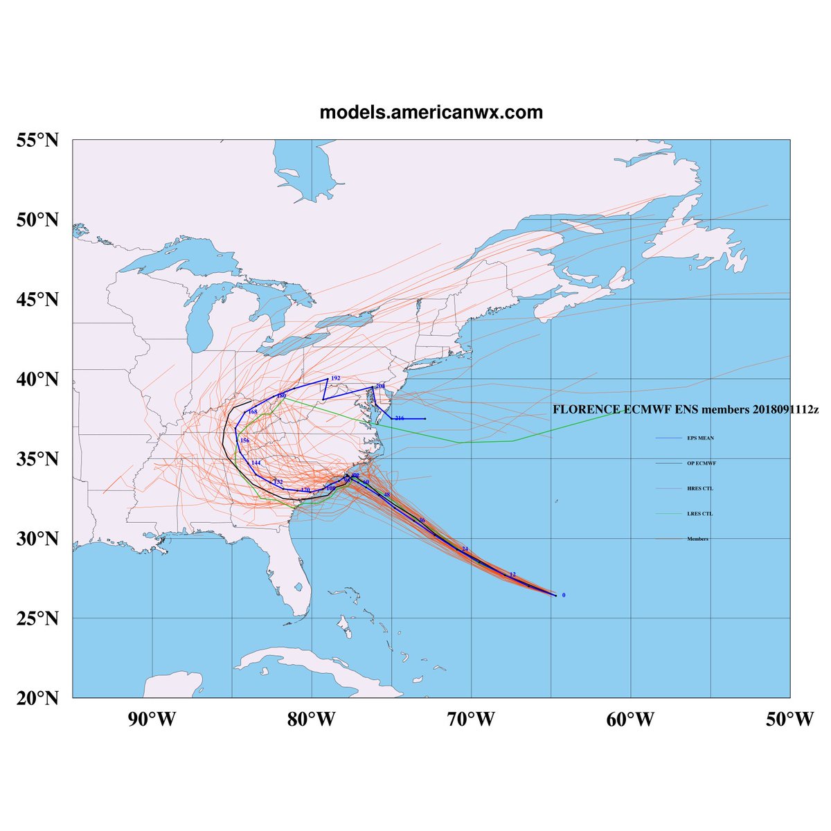
When someone gets the EPS "mean" track map, please post it. All these lines are making me go crosseyed.
Good grief.....
Don't be surprised if we move away from a stall to just a change in direction. This is an anomalous situation, but I just don't believe we will get a prolonged stall.
This has to make it very difficult for the NHC and those who have to make decisions about preparations, evacuations, and closing.Well, after looking over the data, virtually every member of the EPS is sending Florence back South in some way. RUH ROH.

Ohhh, Webb ...Things are only going to get more complicated if Florence mills around off the SE US coast, there's an outside chance that Tropical Storm Isaac gets involved in this mess.
View attachment 6193


View attachment 6192 The Euro as modeled would give GSP area 40-60 mph gusts!!
This has to make it very difficult for the NHC and those who have to make decisions about preparations, evacuations, and closing.
The NHC track should be interesting at 5:00.

Don't you do me like that I'm going to the Gulf coast next weekThings are only going to get more complicated if Florence mills around off the SE US coast, there's an outside chance that Tropical Storm Isaac gets involved in this mess.
View attachment 6193


I would think that the mean of these ensembles would be a pretty good guess at this point. But who knows????
Eye is clearing out on Florence slowly but surely.
All models agree on making it to SE Carolina coast, stalling, and then moving SW to some extent. Question is how far north does it climb.
View attachment 6196
