EPS has been firing warning shotsIt progressively shifted west esp in the last few days of the forecast, but other models, especially the GEFS suite were not even close.
-
Hello, please take a minute to check out our awesome content, contributed by the wonderful members of our community. We hope you'll add your own thoughts and opinions by making a free account!
You are using an out of date browser. It may not display this or other websites correctly.
You should upgrade or use an alternative browser.
You should upgrade or use an alternative browser.
Tropical Major Hurricane Florence
- Thread starter ForsythSnow
- Start date
Looks like I’m back on the tornadoey side of the track, actually, for the first time!View attachment 6172 Another view!
Agreed..I will say kudos to GFS for seeing the stall and movement back SW or W. but euro has been pretty dang rock solid.I was trying to say this yesterday but the contingent that thought this would go NE bc the gfs wouldn't accept it.
Sent from my SM-G955U using Tapatalk
whatalife
Moderator
Personally I'm starting to feel a little better for mby and I'll probably wait until the 12 Z Suites to really start to relax somewhat. But I am starting to get concerned for the SC folks
Sent from my SM-G920V using Tapatalk
Yep. I agree with you. The euro the night before last give the first warning shot for SC. That ridging means business as modeled by the euro last night. Our governor is looking very smart right now by ordering a mandatory evacuation yesterday that has gone into effect today.
Sent from my iPhone using Tapatalk
Webberweather53
Meteorologist
GFS & HWRF are leading the pack for the biggest poleward bias in the day 3-5 range. Surprise!
Not.

Not.
SnowNiner
Member
It’s pretty crazy to have less clarity as we get closer to the event.
I was surprised this morning to wake up and the EURO went back west, and the GFS starting doing loop da loops. I thought everything was going to just keep shifting east. Not sure what's going to happen now. (HPC 5 am discussion below). Just goes to show, we're not going to pinpoint with any accuracy where this thing is going to go until about 24 hours before.
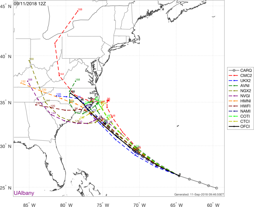
The ECMWF has trended slower this cycle
at days 4 and 5, and as a result the NHC forecast shows slightly
less motion at those time periods. The spread in the guidance
increases by 72 hours, with the GFS and its ensemble mean along the
right side of the guidance, while the ECMWF remains along the left
edge. It should be noted that there are still a number of ECMWF
members that are even farther left. The NHC track forecast has been
nudged to the left and is close to the TVCN consensus aid. Given the
amount of uncertainty by day 3, it is important not to focus on the
exact forecast track as average NHC errors at days 3, 4, and 5 are
about 100, 140 and 180 n mi, respectively, and dangerous hazards
will extend well away from the center. Storm Surge and Hurricane
watches have been issued for a portion of the coast of South and
North Carolina. Additional watches may be required later today.
The cone will be a good bit south by this afternoon,IMO
obviously still tons of uncertainty and at least in my opinion it comes down to how quickly that ridge builds in as to how far north, inland Florence gets before it stalls and crawls Westward. 6 to 12 hour sooner or later and a millibar or two weaker or stronger can mean the difference in 100 miles and a hundred miles is huge with a land falling TC.
Sent from my SM-G920V using Tapatalk
Sent from my SM-G920V using Tapatalk
MichaelAndrews
Member
Traffic is a little bit lower at the moment any chance we can re-enable auto refresh?
Webberweather53
Meteorologist
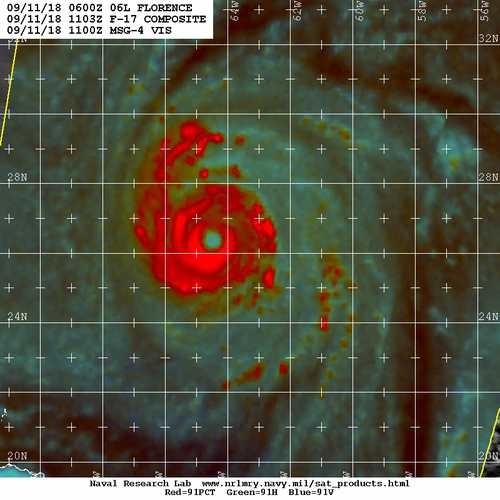
Flight level (FL) winds have increased to 145 knots (~165 mph) in Florence's northeast quad, the typical standard reduction for surface winds is ~130 KTS or so but SFMR only shows 115 KT at the moment & rightfully so. Once the surface winds catch up to the FL winds & the eyewall contracts some, Florence will be knocking on the door of category 5 status.

B
Brick Tamland
Guest
It’s pretty crazy to have less clarity as we get closer to the event.
Yes, it is. Euro looks better for us now, but the UK still has Flo coming in at Wilmington and taking a track like Fran did through Raleigh. And who knows what the GFS is doing.
snowlover91
Member
Eric, a bit scary that her winds aloft are already strengthening again and the large eye is closing off. Would you say this is/has transitioned to an "annular" storm or is it just more the pattern of a very powerful hurricane? I know literature I've read indicates that dry air can often contribute to a storm going annular and there was a ton around Florence and she has shed the majority of her banding.. but I've seen other storms with similar looks that weren't classified that way too.
Webberweather53
Meteorologist
Eric, a bit scary that her winds aloft are already strengthening again and the large eye is closing off. Would you say this is/has transitioned to an "annular" storm or is it just more the pattern of a very powerful hurricane? I know literature I've read indicates that dry air can often contribute to a storm going annular and there was a ton around Florence and she has shed the majority of her banding.. but I've seen other storms with similar looks that weren't classified that way too.
Annular hurricanes often occur w/ aging TCs that have undergone at least one eyewall replacement cycle, are in the presence of low background relative humidity, have lukewarm SSTs (SSTs appear too warm for Florence's case), gently sloping SST gradients so as to not induce large-scale exponentially growing instabilities in/across the breadth of the core, and are in the presence of light easterly shear. Florence seems to fit many of these criteria, so it's probable we see this become annular but the environment isn't perfect (rarely is except in the Northeastern Pacific)
Webberweather53
Meteorologist
Annular hurricanes often occur w/ aging TCs that have undergone at least one eyewall replacement cycle, are in the presence of low background relative humidity, have lukewarm SSTs (SSTs appear too warm for Florence's case), gently sloping SST gradients so as to not induce large-scale exponentially growing instabilities in/across the breadth of the core, and are in the presence of light easterly shear. Florence seems to fit many of these criteria, so it's probable we see this become annular but the environment isn't perfect (rarely is except in the Northeastern Pacific)
You can see we even have light east-southeasterly shear, which is hard to get outside the NE Pacific and far eastern Atlantic near the exit region of the African Easterly Jet (AEJ).
.png")
Webberweather53
Meteorologist
Definitely would be nice to see Florence turn into a big ol donut or truck tire down the line and we have an environment that's somewhat favorable for it to happen. We shall see.
Florence is riding in a pocket of SSTs a little warmer than have been observed in canes that developed annular characteristics. Most literature out there specifies 25-28C as the favorable oceanic environment. As it gets closer to the coastline, it will enter waters right at 28C with little to no shear in its lead up to the coast. Given that annular canes become that way after an ERC, hopefully the timing here is off, otherwise this would be worst case scenario.
The stall and Westward crawl solution is gaining traction

Sent from my SM-G920V using Tapatalk

Sent from my SM-G920V using Tapatalk
Crap! She’s coming for us nowView attachment 6171 From the other board!
If the Euro verifies, North GA could get impacted by Florence.
I don’t think wind will be an issue, especially with the stall, but that rain, could be some flooding!Crap! She’s coming for us now
accu35
Member

I see what you did thereGFS SAYS
Path seems pretty clear atm again when/where it slows and turns big question

packfan98
Moderator
Let's put these types of posts in the banter thread please. Thanks!GFS SAYS
accu35
Member
Sorry man, I got carried aways. Wont happen againLet's put these types of posts in the banter thread please. Thanks!
The image I posted above was suppose to animate but it's not... run the loop, you can see what I'm talking about.
https://www.tropicaltidbits.com/sat/satlooper.php?region=nwatl&product=wv-mid
https://www.tropicaltidbits.com/sat/satlooper.php?region=nwatl&product=wv-mid
B
Brick Tamland
Guest
Saw this at the other board, and it's pretty much crushed my hope of the last Euro run being right and Flo not coming through NC.
The storm needs to come to the Euro then cause so far the track is north of all the recent Euro runs and the Euro is performing worse than most the others....so far...also the storm appears to be moving more NW than anything right now though its tough to tell with the ugly eye but i imagine the separation to the Euro runs is just getting bigger...the FV3 has been very consistent its landfall point hasnt moved more than 10-20 miles run to run for the last 6-8 runs at least.....GFS doing very well so far with track verification...surprisingly enough....still gotta take the blend of the two and thats about where the NHC has it.....the models are doing a bit of back and forth the last day and that probably will continue but overall ILM to MHX is where this likely ends up....
The NHC uses the TVCN for their forecast track its a consensus of the models.....below is the consensus track and verification so far....this is why the NHC has its cone and ath where it does....obviously as the models move around this will too but I doubt we see them move the landfall spot more than 50 miles either way at this point.....there landfall point will shift west 10-15 miles at 11am.....

Showmeyourtds
Member
The image I posted above was suppose to animate but it's not... run the loop, you can see what I'm talking about.
https://www.tropicaltidbits.com/sat/satlooper.php?region=nwatl&product=wv-mid
She still looks to be choking on a little bit of dry air
Kylo
Member
EPS has been to far south past few runs. Still a blend between UK/Euro/FV3 is probably way to go.

Right now she is all over the NHC forecast points..EPS has been to far south past few runs. Still a blend between UK/Euro/FV3 is probably way to go.
View attachment 6176
Attachments

snowlover91
Member
Nice observation there Kylo. EPS has been too far south all along just like the GEFS has been too far north and east. A track in the middle around Wilmington to Morehead City I would favor. Also something that hasn't been discussed yet but in systems where the steering currents break down I've noticed, along the NC coast at least, that storms like to "curve" along the coast if there isn't anything to push it inland. Ophelia was a good example of that a few years back. If the steering currents take awhile to push her inland she could easily just drift around the coast in ways that aren't well modeled right now. Something to watch out for as we get closer to landfall.
accu35
Member
snowlover91
Member
Right now she is all over the NHC forecast points..
NHC has been money with Florence. Their current track and landfall location is a great blend of the guidance and probably pretty close to what we see, give or take 30-50 miles in either direction due to any wobbles near landfall.
Yep and actually if you look at the sat pic I posted in motion you could argue that on it's current track it will be just north of the next point but again any slight west wobble/jog will be spot on it...NHC has been money with Florence. Their current track and landfall location is a great blend of the guidance and probably pretty close to what we see, give or take 30-50 miles in either direction due to any wobbles near landfall.
Kylo
Member
Latest tracks. Sure does look like ILM, maybe just north, is right in the middle.

snowlover91
Member
FWIW the 12z NAM is coming in a little weaker and north with the ridging and a faster movement of Florence at hour 48. It is the NAM though so I'd take it with a grain of salt.
Cary_Snow95
Member
Those tracks outside of the euro are going to be very bad for inland flooding for central NC, spefically the UKMET
Latest tracks. Sure does look like ILM, maybe just north, is right in the middle.
View attachment 6178
accu35
Member
B
Brick Tamland
Guest
Something I have not seen mentioned is the threat of tornadoes with Flo coming in. Is that a possibility?
Kylo
Member
Those tracks outside of the euro are going to be very bad for inland flooding for central NC, spefically the UKMET
Nothing but bad news for the area. I guess only hope now is it stall off the coast and really weakens before coming inland.