Probably basing it off of this but I wouldn't can't on that just yet....B Rad P., the G.OA.T, says tracks are shifting North!????

Probably basing it off of this but I wouldn't can't on that just yet....B Rad P., the G.OA.T, says tracks are shifting North!????
Whoa where did this voice of reason come from?Lots of concern over movement , should take on more a NW component in the next 18 hours . Everything looks right on track so far
Sent from my iPhone using Tapatalk
AgreedLots of concern over movement , should take on more a NW component in the next 18 hours . Everything looks right on track so far
Sent from my iPhone using Tapatalk
Whoa where did this voice of reason come from?
Anyway I did take one look at the 12z initialized hurricane track model guidance I posted above and may need to change pants....
Have no idea, used to be the floaters on NHC but all of that has changed.... I'm getting old I don't like change as much as I used to.Does anyone have the site where you can overlay the national hurricane center forecast tracks to the satellite picture. I can’t find it anymore, thank you guys and gals
Does anyone have the site where you can overlay the national hurricane center forecast tracks to the satellite picture. I can’t find it anymore, thank you guys and gals
[/QUOTE]Is it this page?
http://www.ssd.noaa.gov/PS/TROP/floaters/06L/06L_floater.html
Sent from my iPhone using Tapatalk
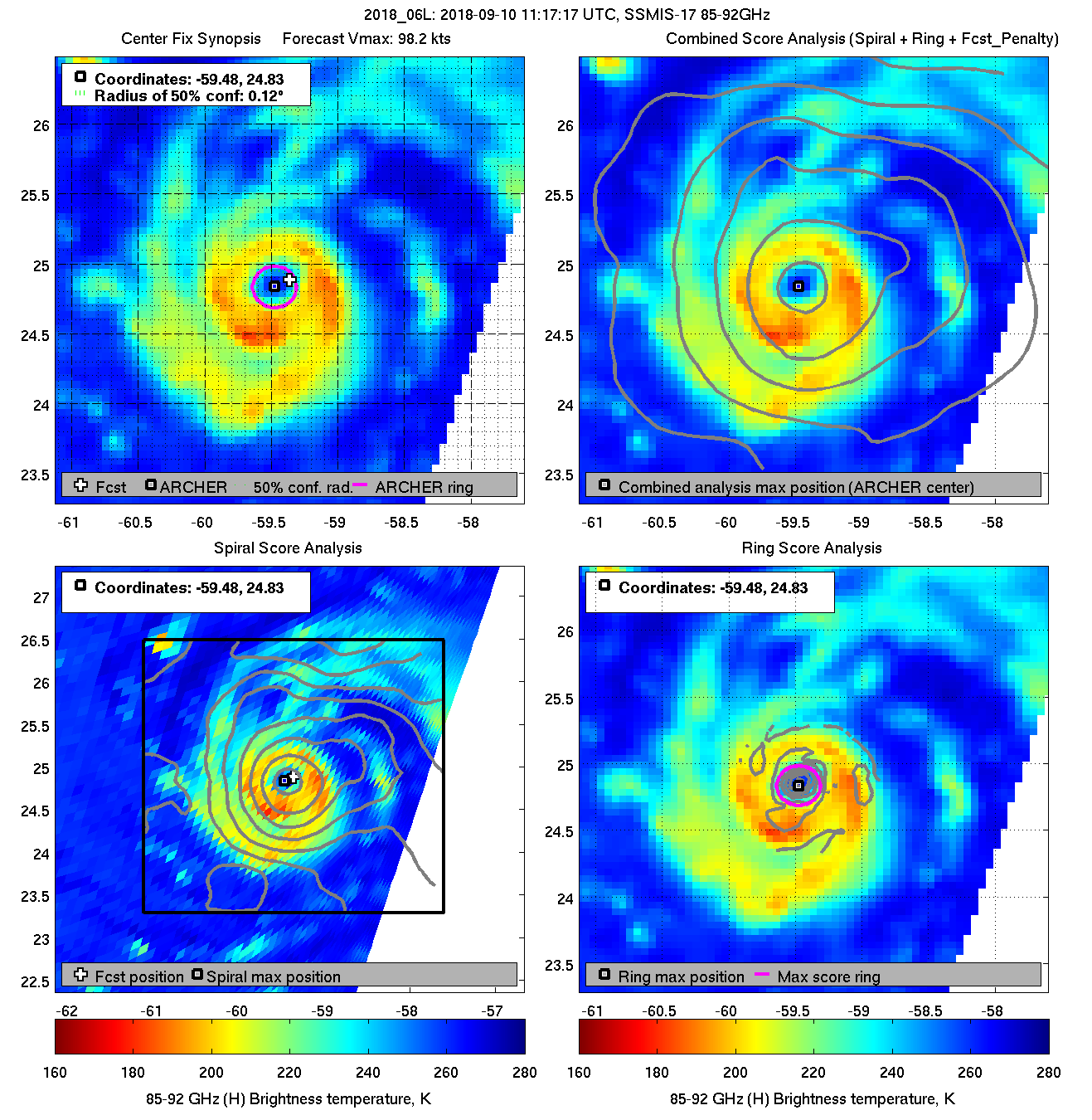
The eye really tightened up over night. She looks very healthy atmLatest microwave looks very healthy.
The eye really tightened up over night. She looks very healthy atm
I notice models have a very large eye at landfall with an expanding wind field, again a little reminiscent of Irene to me, long duration winds over a large area equals major power outages issues in addition to the other horrors this storm could bring.Yeah recon will be there soon, I'm curious to see what they find. I think she will peak sometime today, undergo an EWRC tonight or tomorrow, then the new eye will be much larger and a second peak prior to landfall is likely.
Its fascinating to me that models have set up 2 camps and really not budgedSo it's the NAM and is sucks I know but @51 which is about as far out as the NAM is any good, it has that ridge oriented more SE to NW allowing a more northern movement
And FWIW the NAM actually doesn't make landfall, starts stalling off the OBX at the end of it's run.... LolIts fascinating to me that models have set up 2 camps and really not budged
Sent from my SM-G955U using Tapatalk
Interests in the southeastern and mid-Atlantic states should monitor
the progress of Florence. Storm Surge and Hurricane watches could
be issued for portions of these areas by Tuesday morning.
Is it expected to have dropped 24mb in a 24hr period? Also, I’m curious where this thing is at now compared to what the euro depicted last night. Looks like it’s still moving West..11:00 AM AST Mon Sep 10
Location: 25.0°N 60.0°W
Moving: W at 13 mph
Min pressure: 962 mb
Max sustained: 115 mph
To be fair, I evacuated from Gustav in 2008 in New Orleans. The state waited an extra day to call for the evacuation because LSU was playing football on that Saturday. In the South, football is greater than death.So here's something crazy! I said earlier that Campbell University was sending students home tomorrow, I was incorrect. My daughter just called, she works with the Football team, their game with Coastal Carolina in Myrtle Beach mind you, has been moved from Saturday to Wednesday?! What the heck?! While there will most likely be evacuations ongoing they are anticipating heading there to play a game? No way.....

Is it expected to have dropped 24mb in a 24hr period? Also, I’m curious where this thing is at now compared to what the euro depicted last night. Looks like it’s still moving West..
Shows it as a hurricane now inland. Barely moves in 24 hours also. That track would be almost the worst possible scenario for the Raleigh area.No change in track yet....

Shows it as a hurricane now inland. Barely moves in 24 hours also. That track would be almost the worst possible scenario for the Raleigh area.
Shows it as a hurricane now inland. Barely moves in 24 hours also. That track would be almost the worst possible scenario for the Raleigh area.