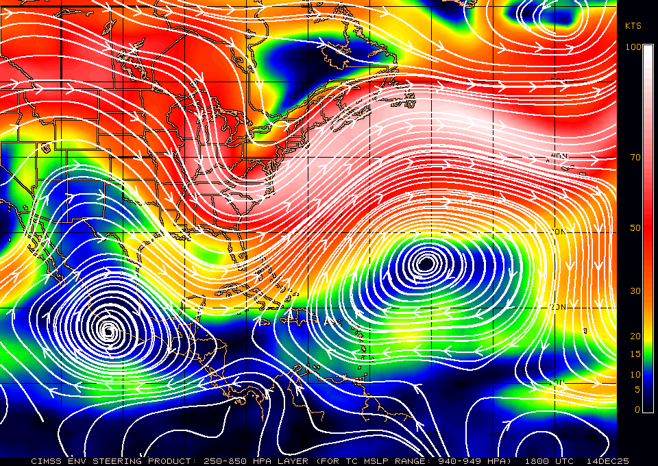
Is that an ULL near FL?? Won’t that pull it west?View attachment 6102 Current steering
-
Hello, please take a minute to check out our awesome content, contributed by the wonderful members of our community. We hope you'll add your own thoughts and opinions by making a free account!
You are using an out of date browser. It may not display this or other websites correctly.
You should upgrade or use an alternative browser.
You should upgrade or use an alternative browser.
Tropical Major Hurricane Florence
- Thread starter ForsythSnow
- Start date
Yeah I was just looking at this and I could see it start to gain some latitude soon
Sent from my SM-G920V using Tapatalk
View attachment 6102 Current steering
Sent from my SM-G920V using Tapatalk
WeatherAddiction
Member
How likely does the cone shift w EPS and ECMWF models in agreement
Webberweather53
Meteorologist
Hurricane force wind gusts made it well inland on last night's Euro run. Given how saturated the ground will be you'll only need 40-45 KT gusts to start seeing a lot of trees come down.
.png")
I am actually not sure that it will gain much latitude today. The stronger she becomes, I did notice the other level above this (for steering) the ridge to the north was actually a bit stronger. So, I think a basic W (westerly) movement for today looks possible. I would say maybe 275-290 heading?Yeah I was just looking at this and I could see it start to gain some latitude soon
Sent from my SM-G920V using Tapatalk
NorthGaWinter4
Member
Hurricane force wind gusts made it well inland on last night's Euro run. Given how saturated the ground will be you'll only need 40-45 KT gusts to start seeing a lot of trees come down.
View attachment 6103
Wouldn’t this have major impacts for north Georgia too? Wherever it hits it shows a stall....... not good
Webberweather53
Meteorologist
I know this has already been posted but there was a shift south in the EPS clustering last night towards SC, hopefully this doesn't become a trend in NWP over the next day or so.
.png")
Webberweather53
Meteorologist
Wouldn’t this have major impacts for north Georgia too? Wherever it hits it shows a stall....... not good
To get major impacts in GA including areas like Atlanta & Macon, you'll need to see this storm take a track south of Charleston, towards Savannah &/or the SC/GA border. That solution unfortunately is still on the table.
NorthGaWinter4
Member
The more south it goes the stronger, correct?I know this has already been posted but there was a shift south in the EPS clustering last night towards SC, hopefully this doesn't become a trend in NWP over the next day or so.
View attachment 6104
Agreed it would have a WNW trajectory at the next level, very close to the NHC track.... either way she's looking mean now and if she's going to start to feel the weakness and gain any latitude it's nowI am actually not sure that it will gain much latitude today. The stronger she becomes, I did notice the other level above this (for steering) the ridge to the north was actually a bit stronger. So, I think a basic W (westerly) movement for today looks possible. I would say maybe 275-290 heading?
Can't post the pic, maybe someone else can but the Uk ens was all over NC last night.....
B
Brick Tamland
Guest
So, the GFS comes in line with the Euro, and then the Euro goes further south into SC. Madness.
Best I can do haha.... mogreps

Sent from my SM-G920V using Tapatalk

Sent from my SM-G920V using Tapatalk
Yellow Snow
Member
I still like absolutely nothing of what I am seeing from the models. The southward Euro and EPS not ideal, the northward GFS not ideal, the FV3 splits the difference and sucks too.
MichaelAndrews
Member
Today should paint a very clear picture of where this bad boy is headed, nobody is out in the clear yet
I think it’ll take another day or two before things clear up a whole lot. We have mostly converged on a hit, but the location is still quite variable.Today should paint a very clear picture of where this bad boy is headed, nobody is out in the clear yet
Yeah at your location you need a massive shift south or a massive shift Northeast to not feel significant impacts. The Southward shift of the Euro last night brought very minimal impacts here.
Sent from my SM-G920V using Tapatalk
I still like absolutely nothing of what I am seeing from the models. The southward Euro and EPS not ideal, the northward GFS not ideal, the FV3 splits the difference and sucks too.
Sent from my SM-G920V using Tapatalk
Yeah at your location you need a massive shift south or a massive shift Northeast to not feel significant impacts. The Southward shift of the Euro last night brought very minimal impacts here.
Sent from my SM-G920V using Tapatalk
Yeah that southward track really takes the northern tier of NC out of the woods, another 50 miles south of what the Euro had a good part of NC is out of the woods from significant wind damage north of the 74/76 corridor.
I'm not sure if we can get this much farther south though..
Storm5
Member
Yeah at your location you need a massive shift south or a massive shift Northeast to not feel significant impacts. The Southward shift of the Euro last night brought very minimal impacts here.
Sent from my SM-G920V using Tapatalk
I just text him and told him to look on the bright side. When the power goes out he won’t have to watch NC State football . So Florence is actually doing him a favor

Sent from my iPhone using Tapatalk
I'm concerned about people in the southern part of the state, many of them are just getting Federal disaster aid from the flooding of Matthew two years ago they certainly don't need this.
Sent from my SM-G920V using Tapatalk
Yeah that southward track really takes the northern tier of NC out of the woods, another 50 miles south of what the Euro had a good part of NC is out of the woods from significant wind damage north of the 74/76 corridor.
I'm not sure if we can get this much farther south though..
Sent from my SM-G920V using Tapatalk
Blue_Ridge_Escarpment
Member
6Z HWRF almost a carbon copy of 0Z Euro. No bueno.
It'll be interesting to see if they play....we played ND in the midst of Matthew.I just text him and told him to look on the bright side. When the power goes out he won’t have to watch NC State football . So Florence is actually doing him a favor
Sent from my iPhone using Tapatalk
Might be hard to throw the football in 80 kt winds.It'll be interesting to see if they play....we played ND in the midst of Matthew.
Gotta have a solid running gameMight be hard to throw the football in 80 kt winds.
Sent from my SM-G955U using Tapatalk
Reading up on Fran (96) as it's the closest landfalling major hurricane vs the NHC track for Florence. Just mind boggling that ﹰTopsail Island was overwashed even though Fran was a CAT 3 and hit a good 60 miles south.
Been at work 1 hour and already tired of the arm chair mets in the office
Sent from my SM-G955U using Tapatalk
Sent from my SM-G955U using Tapatalk
ForsythSnow
Moderator
Florence definitely was moving WNW, however, she appears to have decreased her angle of movement back down a bit. Good news is that we are getting fresh data from one of the panes at the moment, so we will see what 12Z is vs 0Z, which looked worrying to me as I see a clear trend more towards SC, mainly the EPS and HWRF.
packfan98
Moderator
I have a question. Does anyone know the protocol for evacuations? If an area looks to get hurricane force winds and over a foot of rain well inland, would they try to evacuate the area? I'm thinking of areas like Fayetteville to possibly areas like the Triad or Triangle depending on how the storm tracks? It's certainly a life threatening situation with the likelihood of many being without power for over a week.
snowlover91
Member
Here's an interesting article worth reading with the current model wars going on. The FV3 outperformed the Euro when forecasting Hurricane Lane and the impacts to Hawaii in the 4-5 day range and was neck and neck with the Euro inside 72 hours. Although it's a different steering setup and situation with Florence it's possible the FV3 model could have the more accurate picture on track... it also aligns quite closely with the NHC as of the 06z run. Thoughts?
https://www.washingtonpost.com/news...ne-lane/?noredirect=on&utm_term=.5af2b035eaa8
https://www.washingtonpost.com/news...ne-lane/?noredirect=on&utm_term=.5af2b035eaa8
Might be hard to run in 19” of rain.Gotta have a solid running game
Sent from my SM-G955U using Tapatalk
B
Brick Tamland
Guest
State, Duke, and UNC all had to play that day. That was a really crappy deal for fans.It'll be interesting to see if they play....we played ND in the midst of Matthew.
Nomanslandva
Member
Are the 6z and 18z hurricane models run on new data or are they like the other off cycle stuff and just a rerun with a different starting point? Also, I am not liking the new satellite page or just haven't figured it out yet.
ForsythSnow
Moderator
Typically the government will tell people when it gets within 4 or 3 days, then they will do zones starting with the highest chance for highest impact. As for inland, they never will call evacuations there unless you live in a flood-prone area.I have a question. Does anyone know the protocol for evacuations? If an area looks to get hurricane force winds and over a foot of rain well inland, would they try to evacuate the area? I'm thinking of areas like Fayetteville to possibly areas like the Triad or Triangle depending on how the storm tracks? It's certainly a life threatening situation with the likelihood of many being without power for over a week.
As for the storm at the moment, microwave imagery looks bad. The eye appears to be shrinking and heavy convection building up.
Just like winter, cut those totals by 3/4 and you might get close to total precip!Might be hard to run in 19” of rain.
Webberweather53
Meteorologist
I usually don't put as much faith into the GFS/GEFS/Fv3 camp vs the EPS in cases like this where we have a strong tropical cyclone riding the edge of a rapidly building subtropical high that'll only be reinforced by Florence's upper level outflow thru -PV deposition. I've seen this movie play out so many times and know better than to ride the underdispersive & poleward biased GFS/GEFS suites. Fv3 seems to be doing better in this respect w/ more realistic intensity & track but I'll still take the Euro/EPS over it.
So 12z models will have data from the first real recon flight from this morning!?
B
Brick Tamland
Guest
Going to be interesting to see what the models do today. It looked like they were coming into agreement until the Euro went south again last night. Looks like the NHC track stayed the same, though.
Webberweather53
Meteorologist
Florence has become a major hurricane again.
AL, 06, 2018091012, , BEST, 0, 249N, 595W, 100, 962, HU
AL, 06, 2018091012, , BEST, 0, 249N, 595W, 100, 962, HU
Movement?Florence has become a major hurricane again.
AL, 06, 2018091012, , BEST, 0, 249N, 595W, 100, 962, HU