The last several runs of the GFS have been pretty concerning. A landfalling major hurricane is bad enough. But if she stalls soon after landfall, the rainfall amounts would lead to catastrophe. Just two years ago my own local area had 20 to 30 inches (31 in my own location) in a 36-48 hour time span. The flooding was the worst my area had ever seen, with numerous water rescues. I wish the best for all concerned. Stay safe guys!
-
Hello, please take a minute to check out our awesome content, contributed by the wonderful members of our community. We hope you'll add your own thoughts and opinions by making a free account!
You are using an out of date browser. It may not display this or other websites correctly.
You should upgrade or use an alternative browser.
You should upgrade or use an alternative browser.
Tropical Major Hurricane Florence
- Thread starter ForsythSnow
- Start date
no latitude gain yet, maybe a slight jog south at the end?
no latitude gain yet, maybe a slight jog south at the end?
Isn't it suppose to been already gain some latitude??
no latitude gain yet, maybe a slight jog south at the end?
The storm is still showing a very squashed oval profile from west to east. Makes me think the west motion may go on a while yet. Add in that dry air is still getting into the center tells me strengthening will be slow for a little while longer.
The longer it takes to gain latitude, the increase chance for the storm track to shift south/west in the longer term.The storm is still showing a very squashed oval profile from west to east. Makes me think the west motion may go on a while yet. Add in that dry air is still getting into the center tells me strengthening will be slow for a little while longer.
B
Brick Tamland
Guest
Only good thing I see up this way is the NHC has it weakening faster after hitting land. Before they had it a hurricane longer inland.
Cary_Snow95
Member
It still will be. Allan Huffman on twitter noted that the written discussion kept it as a 100mph storm inland. He thinks they just made a mistake with the graphicOnly good thing I see up this way is the NHC has it weakening faster after hitting land. Before they had it a hurricane longer inland.
ForsythSnow
Moderator
He must have looked at the wrong advisory, as this is the latest.It still will be. Allan Huffman on twitter noted that the written discussion kept it as a 100mph storm inland. He thinks they just made a mistake with the graphic
INIT 09/2100Z 24.4N 57.0W 75 KT 85 MPH
12H 10/0600Z 24.6N 58.3W 90 KT 105 MPH
24H 10/1800Z 25.1N 60.4W 105 KT 120 MPH
36H 11/0600Z 25.9N 63.1W 115 KT 130 MPH
48H 11/1800Z 27.0N 66.2W 125 KT 145 MPH
72H 12/1800Z 30.3N 72.6W 130 KT 150 MPH
96H 13/1800Z 33.5N 77.5W 120 KT 140 MPH
120H 14/1800Z 35.0N 79.0W 60 KT 70 MPH...INLAND
18z FV3-GFS is similar to the 12z EURO, tracks Florence well west inland into South/Central NC.

The Models continues to shift further south and west something to monitor.18z FV3-GFS is similar to the 12z EURO, tracks Florence well west inland into South/Central NC.
accu35
Member
Webberweather53
Meteorologist
accu35
Member
pcbjr
Member
Folks,
Please be careful; don't play; and stay safe!
Somewhere back in this thread I posted a link to a discussion we had last year on 'Cane preparation and survival. In case you missed it, or if further info is needed, please see the attached checklists. 149 mph, or 100 mph, or 80 mph inland, is not a party and nothing to play with.
Good luck, and sorry to be parenting, but I'd hate for anything to happen that causes any of you to suffer.
Best and please stay safe if you get hit by this little lady ...
Your Curmudgeon, and Friend,
Phil
Yellow Snow
Member
Yep, he must have been looking at Advisory #41 from 11:00am which did show 100 mph inland; I made a screen cap of the interactive cone map at the time to send to a friend in Chapel Hill because I found it to be so alarming. If you look at the map now it shows 70 mph inland for hour 120 (which is from Advisory #42 at 5pm).He must have looked at the wrong advisory, as this is the latest.
Attachments
weatherguy
Member
I pinned that thread from last year if anyone wants to read for advice or have suggestions to add.... thanks PhilFolks,
Please be careful; don't play; and stay safe!
Somewhere back in this thread I posted a link to a discussion we had last year on 'Cane preparation and survival. In case you missed it, or if further info is needed, please see the attached checklists. 149 mph, or 100 mph, or 80 mph inland, is not a party and nothing to play with.
Good luck, and sorry to be parenting, but I'd hate for anything to happen that causes any of you to suffer.
Best and please stay safe if you get hit by this little lady ...
Your Curmudgeon, and Friend,
Phil
View attachment 6074 View attachment 6075
B
Brick Tamland
Guest
Confused on what the wind is going to be here. I have seen some maps have 70 mph and some have 100mph
ForsythSnow
Moderator
This reminds me, but I think we should make a thread for call maps, idea maps, etc for this storm.
Really too early to tell.... it could be anywhere from 40 to 100 gustConfused on what the wind is going to be here. I have seen some maps have 70 mph and some have 100mph
accu35
Member
pcbjr
Member
You may be a tad low, depending ...Really too early to tell.... it could be anywhere from 40 to 100 gust

Michael21
Member
When you believe Hurricane Florence will turn WNW instead of W like it's doing now?I doubt my area will be impacted by this system,but feel there still a outside chance that Georgia could be impacted according to some Euro Ensembles .
accu35
Member
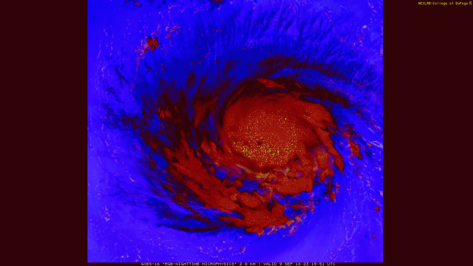
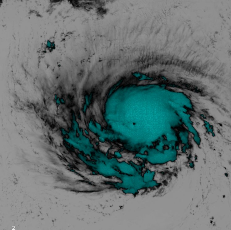
Sat images can be deceiving and have to wait a few more frames to see but I swear it looks like a pinhole eye forming.... if so ru roh
BHS1975
Member
Sat images can be deceiving and have to wait a few more frames to see but I swear it looks like a pinhole eye forming.... if so ru roh
Might be a slug of dry air.
Sent from my iPhone using Tapatalk
accu35
Member
TWC confirmed it was trying to form an eye. Will seeMight be a slug of dry air.
Sent from my iPhone using Tapatalk
Yeah no doubt it could be and it's fooled me before, that's why I say a few more frames to see for sure but looks like a solid ring around it....Might be a slug of dry air.
Sent from my iPhone using Tapatalk
ForsythSnow
Moderator
I agree that this looks to be dry air. Meanwhile the HWRF and HMON are a hair south of their prior runs.Might be a slug of dry air.
Sent from my iPhone using Tapatalk
pcbjr
Member
Just one thing I hate to seeYeah no doubt it could be and it's fooled me before, that's why I say a few more frames to see for sure but looks like a solid ring around it....
A smilin' woman and a frownin' man
With a ring in his nose
And a ring on her hand ...
Savoy Brown Blues Band
Couldn't resist, but feel free to delete ...
packfan98
Moderator
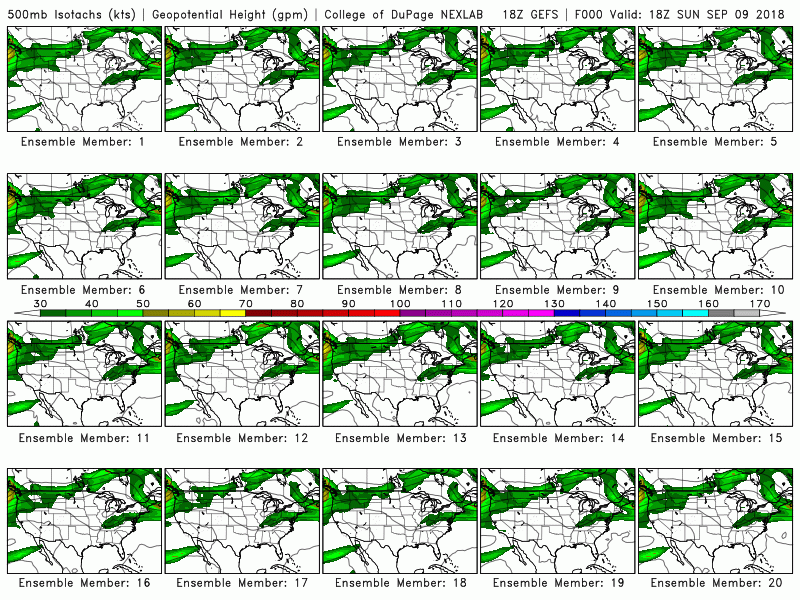
The 18z GEFS is very much in line with other modeling and SW of the 12z run.

ForsythSnow
Moderator
Yeah no doubt it's dry air. No way the storm isn't moving and its filling in. Here's the 1 minute updating satellite imagery.
https://www.tropicaltidbits.com/sat/satlooper.php?region=meso2&product=ir
https://www.tropicaltidbits.com/sat/satlooper.php?region=meso2&product=ir
Yeah no doubt it could be and it's fooled me before, that's why I say a few more frames to see for sure but looks like a solid ring around it....
I was thinking it was the eye, but I'm not sure either. Either way there's more hot towers of convection flaring up right on the southside of it. It even seems to be shedding off some of the outer bands and taking on a more symmetrical appearance.
StormNine59
Member
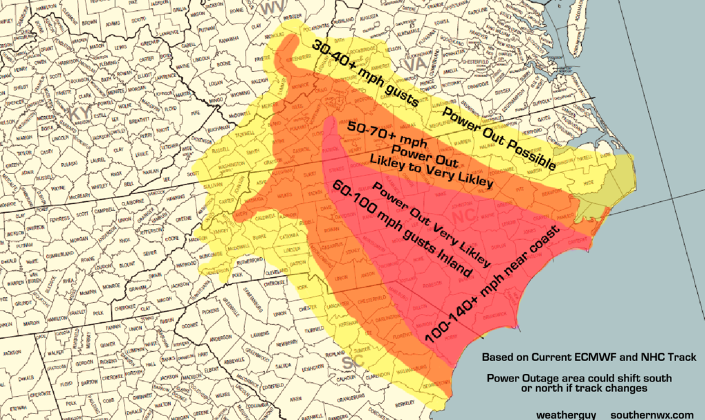
I remember in 2008 having to experience the remnants of Ike merging with a cold front. It was extratropical at that point but the widespread 50-70MPH winds for several hours and that ended up causing many power outages across the state of Kentucky. Some areas closer to the Ohio River that received the higher gusts lost power for almost 1 week. The damage in the state of Kentucky was in the Hundred's of Millions due to all the power issues and the trees down.
If the current NHC forecast is correct a large swath from Myrtle Beach through Raleigh and perhaps as far inland as Snowshoe, WV will experience winds at least at the intensity and duration of what KY experienced in 2008 with Ike and the Cold Front combo. With Hurricane wind gusts as far inland as Fayetteville and Raleigh.
The moral of the story is just because it is a just a strong Tropical Storm instead of a strong CAT 1 or CAT 2 at Fayetteville doesn't spare a large swath of the impacted area from potential power issues and wind damage.
B
Brick Tamland
Guest
Anyone think it could go further west before turning north and hit SC instead of NC?
accu35
Member
LOL, it to early to really say.Anyone think it could go further west before turning north and hit SC instead of NC?
That's what I was using and why I said it would take a few more frames to be sure, anyway it does look like it was definitely dry air.... still some deep convection on the south side so it's trying to get goingYeah no doubt it's dry air. No way the storm isn't moving and its filling in. Here's the 1 minute updating satellite imagery.
https://www.tropicaltidbits.com/sat/satlooper.php?region=meso2&product=ir
Of course, that's why SC is also in the cone...... famous words "don't focus on a single point"Anyone think it could go further west before turning north and hit SC instead of NC?
Still moving west based on satellite. I don’t think that was an eye, just a burp of dry air!