What is your storm total ?3.08 since 830 last night..
Sent from my SM-G955U using Tapatalk
-
Hello, please take a minute to check out our awesome content, contributed by the wonderful members of our community. We hope you'll add your own thoughts and opinions by making a free account!
You are using an out of date browser. It may not display this or other websites correctly.
You should upgrade or use an alternative browser.
You should upgrade or use an alternative browser.
Tropical Major Hurricane Florence
- Thread starter ForsythSnow
- Start date
Good deal. Rain falling makes for good sleeping weather.Actually yes lol
Sent from my SM-G955U using Tapatalk
Not 100% certain since I was a dummy and got the wrong batteries for my weather station to back up I lost data for a good part of yesterday. I think a safe guess is 4-4.5. There is a corcorahs report just a couple of miles away of 3.8 and that was through 7amWhat is your storm total ?
Sent from my SM-G955U using Tapatalk
No kidding and staying up for the fv3 gfs then getting up for work makes for a sleepy weather nerdGood deal. Rain falling makes for good sleeping weather.
Sent from my SM-G955U using Tapatalk
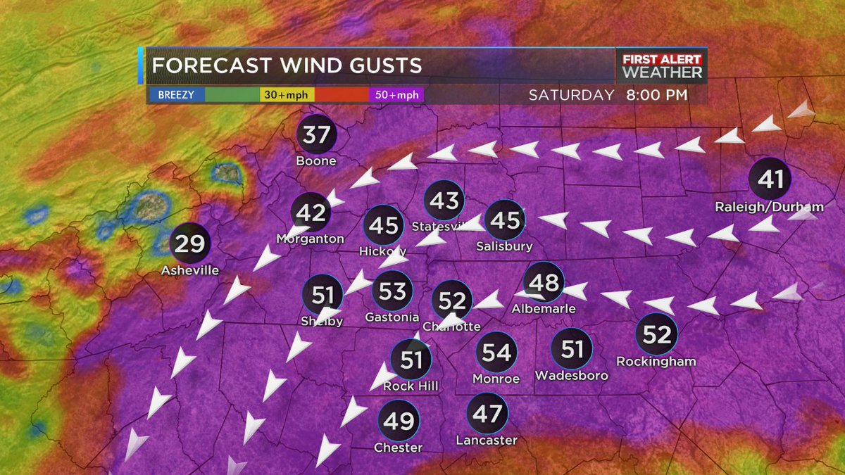
Euro has been high on gusts I think the 0z run friday said 80mph gusts here. But there is still some potential for high gusts especially as you increase your precip rates and/or elevation.How likely is it that the upper winds will work down to the surface as the Euro is showing? I didn't find any other models that were showing 50-70 mph winds at the surface in the western half of NC.
TW
Sent from my SM-G955U using Tapatalk
From JB this morning!!
Euro shows tightening of gradient between Florence and mountains creating alignment for transfer to surface of strong winds upstate SC in NC, Wind gust 50-70 mph this afternoon and tonight well inland( all the way to Charolotte/Greenville, Spartanburg. Tornado threat increasing
Euro shows tightening of gradient between Florence and mountains creating alignment for transfer to surface of strong winds upstate SC in NC, Wind gust 50-70 mph this afternoon and tonight well inland( all the way to Charolotte/Greenville, Spartanburg. Tornado threat increasing
 Quite the gradient! Almost 5-6” difference, in a single county!
No way! TWC says my highest gust will be 30mph!? JB hype meter, pegged at 10!From JB this morning!!
Euro shows tightening of gradient between Florence and mountains creating alignment for transfer to surface of strong winds upstate SC in NC, Wind gust 50-70 mph this afternoon and tonight well inland( all the way to Charolotte/Greenville, Spartanburg. Tornado threat increasing
May be, NWS says only 35mph gusts here!! Will be interesting to see, We'll know by tomorrow!!! Stay safe down there, stock up on TS snacks!No way! TWC says my highest gust will be 30mph!? JB hype meter, pegged at 10!
")
Never doubt JB!No way! TWC says my highest gust will be 30mph!? JB hype meter, pegged at 10!
GeorgiaGirl
Member
This wind has been a warm wind. The low temp today was 82. So weird that considering a north wind, it's been a warm wind.
The arw2 might be the closest model I've seen to reality on this band
Sent from my SM-G955U using Tapatalk
Sent from my SM-G955U using Tapatalk

Or Robert!:weenie:Never doubt JB!
Hope he got a generator!
Ha just wait till winter!No kidding and staying up for the fv3 gfs then getting up for work makes for a sleepy weather nerd
Sent from my SM-G955U using Tapatalk
 Part duh!!!! Sounds almost apocalyptic!!:weenie:
 This seems to say different!
Yeah. The 3k NAM has it well south at hour 1. Does it have the right coordinates in its code?The arw2 might be the closest model I've seen to reality on this band
Sent from my SM-G955U using Tapatalk
It's an hour earlier at least lol.Ha just wait till winter!
Sent from my SM-G955U using Tapatalk
Slight shift northward with the mega firehouse...Yeah. The 3k NAM has it well south at hour 1. Does it have the right coordinates in its code?

Sent from my SM-G920V using Tapatalk
Doubled down on snacks the last few days! And will have a cookout when power goes out, to use up all the meat! Come on down!!May be, NWS says only 35mph gusts here!! Will be interesting to see, We'll know by tomorrow!!! Stay safe down there, stock up on TS snacks!
3k NAM also slight north shift, I think it's anyone's guess where that death band will finally setup, 25-50 huge difference especially for Shane, RC and the triangle peeps
edit: actually maybe shift north for the eastern edge but for Cen NC just narrows the band and slight south, who knows.... I need to stop and just watch or better yet I'll go outside, sun shining here

Sent from my SM-G920V using Tapatalk
edit: actually maybe shift north for the eastern edge but for Cen NC just narrows the band and slight south, who knows.... I need to stop and just watch or better yet I'll go outside, sun shining here

Sent from my SM-G920V using Tapatalk
 Al Conklin WBTVVerified account @AlConklin 10m10 minutes ago
Getting a bad feeling wind gusts will actually be higher than previously forecast. Models are picking up on the idea of a "funneling effect" setting up between #Florence & the 6,000+ feet mountains to the west of @WBTV_News area, 60 mph+ possible. #NCwx
Yeah man not sure. The one thing I did notice is they both want to bring an enhanced area of fgen through our area late today into tomorrow morning. I wouldn't be too surprised to see a larger rain shield with a band of very heavy rain pushing northward into our area and most of the triangleYeah. The 3k NAM has it well south at hour 1. Does it have the right coordinates in its code?
Sent from my SM-G955U using Tapatalk
Cloud tops cooling off of the NC coast and pushing inland. Radar starting to fill back in to the east
Sent from my SM-G955U using Tapatalk
Sent from my SM-G955U using Tapatalk
BHS1975
Member
Starting to get rotation with these cells on the edge of the death band. If the sun comes out we’re really gonna be in trouble.

Sent from my iPhone using Tapatalk

Sent from my iPhone using Tapatalk
Headed for parts of SE wakeStarting to get rotation with these cells on the edge of the death band. If the sun comes out we’re really gonna be in trouble.
Sent from my iPhone using Tapatalk
Sent from my SM-G955U using Tapatalk
B
Brick Tamland
Guest
Tornado warning out for Sampson County.
Unless other credible models have anything close to the winds the Euro has, I’d expect it to verify way too high based on runs like that for other well inland SE TCs as these inland high wind forecasts appear to be due to a bias.
Blue_Ridge_Escarpment
Member
What the Euro is picking up on and other models catching up, is the mixing that’s going to occur when you gain some elevation causing a tunnel effect between the NE side to the storms and the Blue Ridge.Unless other credible models have anything close to the winds the Euro has, I’d expect it to verify way too high based on runs like that for other well inland SE TCs as these inland high wind forecasts appear to be due to a bias.
B
Brick Tamland
Guest
Tornado warning for Duplin County, too.
What the Euro is picking up on and other models catching up, is the mixing that’s going to occur when you gain some elevation causing a tunnel effect between the NE side to the storms and the Blue Ridge.
I still think it has a bias based on recent storms but appreciate your reply and maybe it will be right this time. Have other low end TSs in a similar position in the past lead to wind gusts of 50-70 mph in Charlotte and Greenville? I’m talking other than in isolated severe tstorms. Are any other models close to as high as Euro? I’m thinking more like 30-50 is likely in Charlotte and GSP. Those are the cities JB referred to.
Last edited:
B
Brick Tamland
Guest
Not sure if I am in the clear or not up here. The rain and wind have both stopped. It has been like that all morning.
Still raining pretty good here.
The track of the center is S of CAE, the heaviest rain stays in NC!??! Winning
Webberweather53
Meteorologist
Conditions are noticeably going downhill here as the day progresses, wind consistently gusting up to about 35-40 mph w/ steady light rain. The bands to the east entering Moore and Montgomery counties will likely partially rain themselves out before reaching Charlotte but expecting things to get worse during the overnight hours. Hopefully the trees around here hold up. USGS observing sites peg the storm-total rainfall just over an inch.
Webberweather53
Meteorologist
Several of my friends that chased the storm down in Wilmington are driving west on I-40 trying to get back to Raleigh, the water is so high in the ditches it's just a few inches away from covering the entire road and they barely squeezed past the section of I-40 near Warsaw before it was closed a while ago.
ForsythSnow
Moderator
Florence is in no hurry to move. looks almost stalled but the advisory has west at 2 mph, and it appears that way if you look closely. Certainly further south than many models portrayed it today, but certainly well north of what the Euro had a few days ago.
B
Brick Tamland
Guest
Here comes the rain again
Falling on my head like a memory
Falling on my head like a new emotion
Falling on my head like a memory
Falling on my head like a new emotion
B
Brick Tamland
Guest
I am sure those dealing with flooding would say you are winning compared to them.The track of the center is S of CAE, the heaviest rain stays in NC!??! Winning
pcbjr
Member
Still amazingly organized ...
https://earth.nullschool.net/#current/wind/surface/level/orthographic=-81.86,35.81,1918

https://earth.nullschool.net/#current/wind/surface/level/orthographic=-81.86,35.81,1918