Lol. We got some pretty good rain the other day though. I think we are OK. Bring on the howling windView attachment 6411
Amazing!
-
Hello, please take a minute to check out our awesome content, contributed by the wonderful members of our community. We hope you'll add your own thoughts and opinions by making a free account!
You are using an out of date browser. It may not display this or other websites correctly.
You should upgrade or use an alternative browser.
You should upgrade or use an alternative browser.
Tropical Major Hurricane Florence
- Thread starter ForsythSnow
- Start date
Icon not really seeing the current axis of moderate to heavy rain either. Weird.
They showed “ future radar” on TWC just now, the problem is the S side of the remnants, are basically void of precip as it basically goes from CAE to GSP! It’s like a naked swirl on the S /SW side, which we are in the whole time! That’s how you suck at rain, and pick up .5-1” from a tropical system!! That’s how we roll!
Showmeyourtds
Member
They showed “ future radar” on TWC just now, the problem is the S side of the remnants, are basically void of precip as it basically goes from CAE to GSP! It’s like a naked swirl on the S /SW side, which we are in the whole time! That’s how you suck at rain, and pick up .5-1” from a tropical system!! That’s how we roll!
Try living in ATL & watching this when you haven’t gotten a drop of rain in 12 d ays
Sent from my iPad using Tapatalk
NWSGSP must be using an in house model to come up with these totals! This is their afternoon discussion, updated at 10:25 tonight!? It even contradicts the rainfall map they issued at 4:10 pm! So what’s it gonna be, .5 or 7.55??
I feel ya! I had a good storm about 3 days ago, got about 1.5”, that was my first rain since August 15th!Try living in ATL & watching this when you haven’t gotten a drop of rain in 12 d ays
Sent from my iPad using Tapatalk
been plenty rainy here in Chattanooga.. I find it hard to believe you're in a drought in the ATL area. So if I go look up ATL area rainfall totals for Sept I'm going to see 0.00 for the past 12 days? lolTry living in ATL & watching this when you haven’t gotten a drop of rain in 12 d ays
Sent from my iPad using Tapatalk
Not really. There have been no organized systems in awhile and July , August, September, usually rely on pop up storms and you may get 3” from a storm and someone 2 miles away , is sunny and drybeen plenty rainy here in Chattanooga.. I find it hard to believe you're in a drought in the ATL area. So if I go look up ATL area rainfall totals for Sept I'm going to see 0.00 for the past 12 days? lol
we'll get 'em eventually.. I doubt this is going to be like Fall 2016, with the wildfires.. what I don't want, is any tropical system giving me 20 inches of rain in 3 days. Who in their right mind would want to get in on that action?
GeorgiaGirl
Member
It was fairly dry until the last 7 days here actually as well...after really raking in rain early last month we had a real dry spell for a while but it seems to have broken.
Well this is the dry season in Atlanta. September through November can be bone dry unless you are lucky enough to get some tropical moisture. And of course you should never count on tropical moisture from a tropical system that strikes the east coast. 99% of the time if Atlanta gets rain from a tropical system it will be coming from the Gulf.Try living in ATL & watching this when you haven’t gotten a drop of rain in 12 d ays
Sent from my iPad using Tapatalk
 The eye is currently running SSW , riding the SC coast from MYR towards CHS, it’s crazy to watch!
sorry, delete my comments mods... off topic
Clem282340
Member
Is flo going to shift far enough south to get all the upstate in the heavy rain
This thread has been mighty quiet. If it were January and flurrying outside there would have been 50 posts in the past hour. I can’t wait to get my dry bands with 40mph gust tomorrow. Should be one for the record books
Brent
Member
This thread has been mighty quiet. If it were January and flurrying outside there would have been 50 posts in the past hour. I can’t wait to get my dry bands with 40mph gust tomorrow. Should be one for the record books
I think people are just over Florence. I know I am
it's like a live pig in a meat grinder... what's the biggest rain total so far?
jwb_84
Member
 tight couplet
Firehose pointed directly at Wake. Got somewhere between 5-6” and climbing. Under all kinds of flood warnings.
The only qpf model that looks remotely right to me is the RGEM.
Maybe it’s finally starting to pivot west and south now?
Kylo
Member
Maybe it’s finally starting to pivot west and south now?
HRRR has Flo gaining latitude through the afternoon so that super band may push north a little. Looks like we will be right on the edge. Going to be out and about today, be nice to get a lull in precip.

packfan98
Moderator
B
Brick Tamland
Guest
Not doing a thing here. Not even raining. Hope I am far enough north to miss the heavy stuff today.
snowlover91
Member
The only qpf model that looks remotely right to me is the RGEM.
The RGEM and it’s higher resolution counterpart the HRDPS have done exceptionally well with the banding and amounts so far. If they’re remotely close then it’s going to get worse.
Here’s what the 06z HRDPS shows for the next 48 hours.

Here’s the 06z RGEM

Yellow Snow
Member
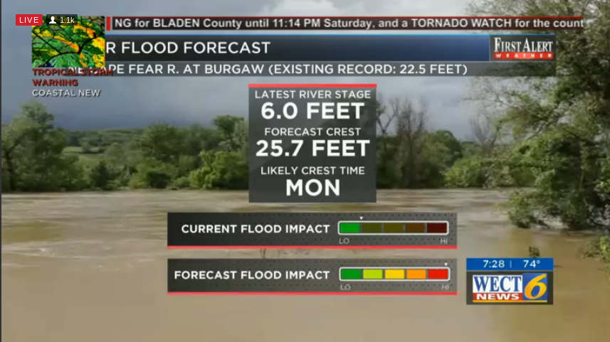
Another aspect of this slow motion natural disaster to consider is overflow river flooding. Surface runoff from rains in the higher elevations will cause a number of rivers in the Carolinas to crest to record heights during the coming week, resulting in even more catastrophic flooding.
I’m glad you mentioned the HRSPS. As silly as it sounds, I’ve been watching that model for the last few days, and it seems to have done quite well. I meant to say something about it the other day, but I forgot. I’ve been impressed with it with this storm.The RGEM and it’s higher resolution counterpart the HRDPS have done exceptionally well with the banding and amounts so far. If they’re remotely close then it’s going to get worse.
Here’s what the 06z HRDPS shows for the next 48 hours.
View attachment 6417
Here’s the 06z RGEM
View attachment 6418
Snownut
Member
If this transfers to the surface there will be some high wind gust for sure across the area western Carolinas

Sent from my SM-G955U using Tapatalk

Sent from my SM-G955U using Tapatalk
Ginnie
Member
Totally new here but the reason I watch these storms is because my daughter used to live in Florida and now lives in Atlanta. Cannot tell you how glad I am to hear she is not in the midst of a hurricane! Last year they decided to "ride out" Irma. Now she gets to sit and worry about us! And sitting here just below Charlotte so far we have wind and about .50" of rain. Power flickered off last night but came back on.Try living in ATL & watching this when you haven’t gotten a drop of rain in 12 d ays
Sent from my iPad using Tapatalk
Clem282340
Member
Will there also be heavy rain tooIf this transfers to the surface there will be some high wind gust for sure across the area western Carolinas
Sent from my SM-G955U using Tapatalk
Snownut
Member
I Think IMO the western Carolinas sees 1-4"Will there also be heavy rain too
Sent from my SM-G955U using Tapatalk
BHS1975
Member
I’m glad you mentioned the HRSPS. As silly as it sounds, I’ve been watching that model for the last few days, and it seems to have done quite well. I meant to say something about it the other day, but I forgot. I’ve been impressed with it with this storm.
Yeah the HRSPS has been very good and right now it’s showing a brief lull before the fire hose comes back. I wish it showed the rest of the country.
Sent from my iPhone using Tapatalk
Tarheelwx
Member
How likely is it that the upper winds will work down to the surface as the Euro is showing? I didn't find any other models that were showing 50-70 mph winds at the surface in the western half of NC.
TW
TW
It does well in winter quite often as well. If correct as BHS mentioned, after a lull you guys will be under the gun again, heck even gets decent amounts up here. Wish we could see how it's handling Florence's movement. Is it turning north sooner or just showing a much more expansive rain shield
Sent from my SM-G920V using Tapatalk
I’m glad you mentioned the HRSPS. As silly as it sounds, I’ve been watching that model for the last few days, and it seems to have done quite well. I meant to say something about it the other day, but I forgot. I’ve been impressed with it with this storm.
Sent from my SM-G920V using Tapatalk
Yeah, they need a SE view on that thing!It does well in winter quite often as well. If correct as BHS mentioned, after a lull you guys will be under the gun again, heck even gets decent amounts up here. Wish we could see how it's handling Florence's movement. Is it turning north sooner or just showing a much more expansive rain shield
Sent from my SM-G920V using Tapatalk
It's a windy and rainy here with this small band as it's been in 3 days.... actually looks like a TS out there haha
Sent from my SM-G920V using Tapatalk
Sent from my SM-G920V using Tapatalk
Where’s SD? He sleeping in this morning?
BHS1975
Member
It does well in winter quite often as well. If correct as BHS mentioned, after a lull you guys will be under the gun again, heck even gets decent amounts up here. Wish we could see how it's handling Florence's movement. Is it turning north sooner or just showing a much more expansive rain shield
Sent from my SM-G920V using Tapatalk
I’m thinking it’s just an expanding rain shield as the flow becomes more from the south.
Sent from my iPhone using Tapatalk
3.08 since 830 last night..
Sent from my SM-G955U using Tapatalk
Sent from my SM-G955U using Tapatalk
Actually yes lolWhere’s SD? He sleeping in this morning?
Sent from my SM-G955U using Tapatalk