What a jet structure not that many miles east and it would have buried the region
could you screen shot back to the west please.

could you screen shot back to the west please.

disagree, it lingers, some models have it sat through tuesday...euro has it early monday into the overnight before it ends...gfs is a long event too, just looked and it covers about 24 hoursRemember when we were looking at 24 hour plus winter storm . This thing Monday ZIPS through in like six hours
Sent from my iPhone using Tapatalk
all mdels continue to depict an ice storm in my area but i would agree by verification time memphis is going to be the hot spotEuro trending warmer each run . Memphis is the place to be
Sent from my iPhone using Tapatalk
disagree, it lingers, some models have it sat through tuesday...euro has it early monday into the overnight before it ends...gfs is a long event too, just looked and it covers about 24 hours
do what? .82 of ice on the GFS? Canadian is a monster storm, as is the ICON and the Euro has now come around...I don't know what you are seeing...this looks bad for Huntsville and the shoalsIt’s not constant . It’s in little waves and the precip is much lighter . Can still cause problems but far from the monster we were once looking at
Sent from my iPhone using Tapatalk
all mdels continue to depict an ice storm in my area but i would agree by verification time memphis is going to be the hot spot
do what? .82 of ice on the GFS? Canadian is a monster storm, as is the ICON and the Euro has now come around...I don't know what you are seeing...this looks bad for Huntsville and the shoals
Memphis gets multiple winter storms on the euro through next Thursday
Sent from my iPhone using Tapatalk

Question- if the models have a hard time with swallow layers of cold air near the surface, then isn't reasonable to figure in some sort of margin of error as it relates to the east progression shown on the model runs?
I see supercells for me. For the win!!!!Euro trending warmer each run . Memphis is the place to be
Sent from my iPhone using Tapatalk
Yeah it'll be interesting to see where the inverted trough sets up and how far east the sub freezing temps can get for you guys. If I were within 1 or 2 layers of counties from the freezing line on the models I'd certainly keep a watchQuestion- if the models have a hard time with swallow layers of cold air near the surface, then isn't reasonable to figure in some sort of margin of error as it relates to the east progression shown on the model runs?
i would love to see the euro ice accumulation map for midsouth area through next week

what about sleet??
what about sleet??

you and i both around half inch.
Thanks,hopefully we can trend to more sleet and less freezing rain
It’s up to 6-7 according to TWC, from the I-35 pileup aloneThree people died in Dallas this morning because of just 1/10th a coating of ice
Sent from my iPhone using Tapatalk
GFS looked similar to me as well.Memphis gets multiple winter storms on the euro through next Thursday
Sent from my iPhone using Tapatalk


I think a significant winter storm is a lock. The question is, how much is snow vs ice.Wow really hard not get excited about the next week for this area.
Euro
View attachment 73974
Gfs
View attachment 73975
View attachment 73976View attachment 73977View attachment 73978
Guys google ice storm February 1 and 2 1985.
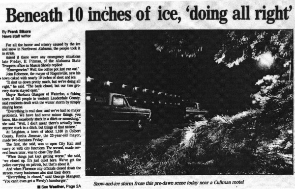
The 1985 Northwest Alabama Winter Storm
On Friday, February 1, 1985, the forecasts were dire for the Birmingham area and much of Central Alabama. It was expected to be the biggest winter storm since the 1982 ice storm. Winter storm warni…www.alabamawx.com
How was that pattern similar to the one we are seeing slip through our models today?
A very slow moving front that fluctuated back and forth before leaving 5 to 6 inches of ice on the ground along with trees and power lines.The 1985 Northwest Alabama Winter Storm
On Friday, February 1, 1985, the forecasts were dire for the Birmingham area and much of Central Alabama. It was expected to be the biggest winter storm since the 1982 ice storm. Winter storm warni…
How was that pattern similar to the one we are seeing slip through our models today?
