JLL1973
Member
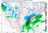
Both icon and gfs with nice winter storms over the midsouth next monday

It parked the TPV over the lakes and didn’t move it. I am willing to put my mortgage on the line that says that will not happen.If you don't want ice (many hate ZR) in GA/SC/NC, the 0Z GFS says you're in luck.
That's a freaking winter storm headed into the SE!
If you don't want ice (many hate ZR) in GA/SC/NC, the 0Z GFS says you're in luck.
Chilly yes, but those temps dont support frozen anywhere in NC, SC, GAnice and chilly
View attachment 73343
Is there anyway we can keep that low from cutting inland?
It really wasn’t. The GFS was going to have an ice storm there. It parked the TPV out of nowhere and wouldn’t allow Hp to slide east and build in. The odds of that happening are slim to none IMOThank the good lord. The ridge is our friend. That was a close call though.
Sent from my iPhone using Tapatalk
actually yes, devastating ice in nw alaVerbatim ... no...
But in actuality... should be yes... the high is entrenching down and the SFC low should be forced to go around and/or transfer east offshore into the western wall of the Gulf Stream...


Don’t do what the GFS did which was park the TPV over the Great Lakes and not move it. That allows HP to build in and keep the LP to the southIs there anyway we can keep that low from cutting inland?

Im willing to learn. Getting where? Those temps are quite a bit warmer than at 150Getting there...
View attachment 73347
actually yes, devastating ice in nw ala View attachment 73346


I might hang out for the UKMET. The nut case shrink formally known as Doc can wait until morning.Im not upgrading the carpet burn watch to a warning tonight. Seen enough to say maybe the rug want get pulled out from underneath us. Next decession will the 12z tommorow.
Not impressive at all. But i can get close to 70 tues then at least it will be enjoyable.V16 isn’t impressed View attachment 73351View attachment 73352
It really wasn’t. The GFS was going to have an ice storm there. It parked the TPV out of nowhere and wouldn’t allow Hp to slide east and build in. The odds of that happening are slim to none IMO
Not exactly. You gotten a bad look but from different reasons. We’ve gone from the TPV trended west and almost dropping into Montana, to finally it pushing east, but getting weaker, now it’s not as weak but it just randomly stops after trucking along? That’s not trends. That’s the complete opposite. Yes you don’t get a wintry look but how it gets there is completely different and this latest look on the GFS is the most unlikely one of the 3 to happen.Except that this look has shown up several times going back a week though pushed out further as time has gone on. I posted about how ridiculous it seemed then. The fact that it keeps showing up means we just can’t dismiss it.
Sent from my iPhone using Tapatalk
Not exactly. You gotten a bad look but from different reasons. We’ve gone from the TPV trended west and almost dropping into Montana, to finally it pushing east, but getting weaker, now it’s not as weak but it just randomly stops after trucking along? That’s not trends. That’s the complete opposite. Yes you don’t get a wintry look but how it gets there is completely different and this latest look on the GFS is the most unlikely one of the 3 to happen.


The Great Texas Blizzard of 2021
If you live in Tx, La, Ms, Ar, Tn, Al, Va you have to feel pretty good about a storm coming at this pointbut damn did it look good back west View attachment 73359

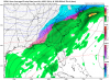
Canadian transfers the low, looks icy for most of ALA and NW corner of GA