• Hello, please take a minute to check out our awesome content, contributed by the wonderful members of our community. We hope you'll add your own thoughts and opinions by making a free account!

Tropical Karen

After a couple of fish storms people may not be paying as much attention to this one and it may pose a marginal threat for someone.
 
Model consensus projections almost always change significantly from this far out and especially when there is an unusual path being shown. Usually the highly unusual path this far out doesn’t verify based on my many years of tracking. There’s an old saying that you want to be in the projected path this far out because it will almost always change a good bit.

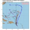
So, the good news is that despite the latest consensus suggesting a hard left and subsequent west movement all the way back to the CONUS is quite possible, there’s at least as good a chance nothing even close to that will verify. How many times this year and in others have we seen early progs of strong ridges blocking and then forcing west to this extent end up changing drastically as the days go along to where the storm instead escapes easily? So, my take right now is to keep this kind of highly unusual potentially dangerous path in mind as just a possibility but not a likelihood at least right now. Besides the path quite possibly drastically changing later and she not even getting close to the CONUS, Karen could end up very weak even if she does get close.

At this early Jerry stage, I was easily willing to lay $50 to win $10 on no CONUS hit or near miss and was saying 90% chance of no hit or near miss. As I said earlier, this is a much different situation and potentially much more dangerous than for Jerry. But, even so, I’d still consider at this early stage odds going somewhat against a hit on the CONUS. But I wouldn’t enthusiastically lay $50 to win $10. I probably wouldn’t lay more than $20 to win $10 right now. Right now, I’m going with about a 2 in 3 chance of no TC hit on the CONUS.
 
In a very dangerous spot and close to October. Anyone got some analogs like Sandy etc
 
With the ridge already projected to weaken a little by this time could this lead the way to a possible pattern change?
 
In a very dangerous spot and close to October. Anyone got some analogs like Sandy etc
Wrong location for Sandy, so an analog would not match.

Yes there is a chance this storm could go OTS, but I'm not sold, and Yes guidance can change. However, I wouldn't just say it's a fish storm just yet. I don't want a major US impact, but I want a pattern change at least. It going OTS would keep this heat rolling.
 
The best scenario is it to stay weak. And hit the southeast. Bring much needed rain. And possibly a pattern change.


Sent from my iPhone using Tapatalk
 
The CMC track was interesting though I loath the CMC as a tropical model since it flat out sucks....it kind of makes sense given the overall setup and I could see this playing out somewhat like that....
 
If Karen develops and move into this spot with that ridge to her north. :oops:

C1DDA9ED-FDE1-43A1-BCF4-EF175B362AF2.png245A0F09-5593-4A17-A2B6-AE50BE0FB0CE.png
 
11 am discussion.....

Given the current sprawling structure, nearby dry
mid-level air, and moderate northwesterly shear, no significant
strengthening is expected through 48 hours. In fact, the system may
have trouble surviving over the eastern Caribbean Sea as the global
models predict an increase in northeasterly upper-level winds over
the system on Monday. Once the cyclone moves north of Puerto Rico,
the shear is forecast to decrease, and some strengthening is
indicated in the official forecast, but this will depend on the
structure of the system at that time. At this time, the long range
intensity forecast is quite uncertain.
 
The NNW then stall portion of the track looks pretty likely after that things are muddy. Does jerry exiting create enough of a weakness so that it's a slow NE drift after the stall? Does a potential upper low help pull it west? Does enough shortwave energy topple over the developing eastern ridge capture karen and pull it back east? Do we see a rapid building of ridge near Bermuda after Jerry ahead of Karen so that it is stopped and forced WSW to SW? Also if you live in a good part of the interior SE it's not going to be easy to get Karen into the area to bring beneficial rain. Closed 591 heights aren't going to let anything into the area and we really need the ridge to either be suppressed SE so Karen can be pulled around the ridge. Or the ridge to shift west so that a trough can dig down the eastern flank and catch it and pull it northward.

Sent from my SM-G975U using Tapatalk
 
12Z: ICON looks like recurve from US while GFS is the opposite though GFS weakens her to a wave.
 
gfs_mslp_pcpn_frzn_seus_35.png
 
GFS is weak weak weak but goes all the way to Texas lol

Brent, the wave that goes to TX actually looks like it isn’t from Karen but rather from a different disturbance coming in behind it from the Caribbean....that is if we’re looking at the same entity.

NM, I’m looking at something later that goes into TX. My mistake.
 
Back
Top