Me waiting for the drought monitor 
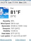
That is some impressive heat! For quite a while the temperature reading at RDU has consistently run anywhere from three to five degrees above the NWS other reporting stations so I take their measurements with a grain of salt. 103 degrees might be a little high but I believe the temperature hit the century mark in spots today. The thermometer at my residence about ten miles SSW of the airport recorded a high of 99 degrees todayLooks like RDU hit 102 today.
Somehow, we are 5+ degrees warmer than Fayetteville and Greensboro.


Me waiting for mid Sept.Me waiting for the drought monitor View attachment 148148
Me waiting for mid Sept.
Still hot and dry? Why wait when it’s what you have now! Some of the hottest I remember is after Fran.Me waiting for mid Sept.
Even with the known bias of the HRRR to mix out dewpoints too much at that range, it really was a very large miss for it… off by 15 degrees in both Richmond and CharlotteThe NWS, which wasn’t quite as hot and wasn’t nearly as dry vs HRRR, did better than the HRRR:
Verification of yesterday’s 6Z HRRR prog for temperature/dewpoint at 19Z/3PM EDT today:
Richmond, VA: HRRR 103/52 vs actual 99/68
Raleigh, NC: HRRR 100/61 vs actual 96/66
Charlotte, NC: HRRR 102/48 vs actual 98/63
Columbia, SC: HRRR 103/58 vs actual 100/60
Florence, SC: HRRR 99/64 vs actual 94/73
Atlanta, GA: HRRR 101/45 vs actual 95/55
Augusta, GA: HRRR 103/46 vs actual 99/52
Brunswick, GA: HRRR 96/66 vs actual 91/78
Summary for 8 cities:
-HRRR was too hot for all 8 with avg miss of +4.4 with range of +3 (Columbia) to +6 (Atlanta)
-HRRR was too dry for all 8 with avg dewpoint miss of -9.4 with range -2 (Columbia) to -16 (Richmond)
3PM data sources:
GA https://kamala.cod.edu/ga/latest.asus42.FFC.KFFC.html
SC https://kamala.cod.edu/sc/latest.asus42.CAE.KCAE.html
NC
RWR from KRAH
kamala.cod.edu
VA
RWR from KAKQ
kamala.cod.edu
Went down even further. Aiken hit 101, it's dewpoint actually dropped to 49. Humidity was 18% at one point. Shortwave high/subsidence pocket. Those areas that blasted the century mark today also saw max mix out. Charleston today never got above 95, dewpoints never mixed below 75. Ridiculous heat index readings across the Lowcountry. Witherbee maxed at 116, Summerville Airport hit 114 (technically Jedburg 5 miles N of Summerville, usually a more sheltered spot), and many 110 readings across the board. Charleston Airport (NWS) hit 107 today.Check this out for something fascinating at Augusta, GA (Bush):
-noon was 93 with a dewpoint of 76 on a SE wind at 9
-1PM was 99 with a dewpoint way down at 58 on a SW wind at 13 gusting to 22!!
That’s a heck of a boundary, a dry line of sorts that went through Augusta last hour! And it came in on SW winds!
@Stormsfury

Same back this way (Wet back porch). Hoping the early morning rain out west can hold together as it heads eastward. Looks promising right now but we've seen similar setups dissipate.A few sprinkles first thing this morning barely wet the road but an encouraging sign...
Same back this way (Wet back porch). Hoping the early morning rain out west can hold together as it heads eastward. Looks promising right now but we've seen similar setups dissipate.
Drought begets droughtSeems concerning
Southeast
Throughout most of the Southeast, rainfall has been largely lacking over the past 3 to 4 weeks. Additionally, much of the region has experienced several heat waves over the past month, resulting in rapidly deteriorating conditions leading up to and including last week. Soil moisture, stream flows, and several derived drought indices are worsening by the day. Impacts are widespread, particularly in the agricultural sector, as pastures and rangelands are going dormant or turning brown, increasing livestock concerns as well. Several reports that crop yields are also in danger if the region doesn’t get any meaningful rainfall soon. High evapotranspiration (i.e. the evaporation of moisture from land and vegetation) rates are rapidly drying out soils and vegetation, increasing fire concerns.
We are at 86/76 with a HI of 96 at 9am. Gonna need the rain to pan outIt's 82/81 here so it's plenty juiced up expect it to break down better today once the sun gets going compared to Monday.
Scape almost 3000 here at 9am lol
Corn crop is toast, it's one thing for it to "roll up" it's another to see it turning brown in the field before tasseling out. Also starting to see some leaves fall, pretty crazy, especially considering I had over 5" last month. But no rain in June coupled with very low DPs (relatively speaking) has brought on a quick, serious situation. A few pop up storms aren't going to fix this eitherSeems concerning
Southeast
Throughout most of the Southeast, rainfall has been largely lacking over the past 3 to 4 weeks. Additionally, much of the region has experienced several heat waves over the past month, resulting in rapidly deteriorating conditions leading up to and including last week. Soil moisture, stream flows, and several derived drought indices are worsening by the day. Impacts are widespread, particularly in the agricultural sector, as pastures and rangelands are going dormant or turning brown, increasing livestock concerns as well. Several reports that crop yields are also in danger if the region doesn’t get any meaningful rainfall soon. High evapotranspiration (i.e. the evaporation of moisture from land and vegetation) rates are rapidly drying out soils and vegetation, increasing fire concerns.
I know these are famously inaccurate but I don't see how I'm not abnormally dry. Everything is brown except my garden which has been watered. That said the ponds and creeks are full.GIDDY UP!
View attachment 148155
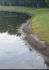
Water levels are crashing here. Ponds showing 2 to 3 feet of new dirtI know these are famously inaccurate but I don't see how I'm not abnormally dry. Everything is brown except my garden which has been watered. That said the ponds and creeks are full.
I imagine the sandy soil doesn't help much. Clay sucks but it is good at holding water.Water levels are crashing here. Ponds showing 2 to 3 feet of new dirt
The grass is so prickly and dry now.Seems concerning
Southeast
Throughout most of the Southeast, rainfall has been largely lacking over the past 3 to 4 weeks. Additionally, much of the region has experienced several heat waves over the past month, resulting in rapidly deteriorating conditions leading up to and including last week. Soil moisture, stream flows, and several derived drought indices are worsening by the day. Impacts are widespread, particularly in the agricultural sector, as pastures and rangelands are going dormant or turning brown, increasing livestock concerns as well. Several reports that crop yields are also in danger if the region doesn’t get any meaningful rainfall soon. High evapotranspiration (i.e. the evaporation of moisture from land and vegetation) rates are rapidly drying out soils and vegetation, increasing fire concerns.
My stream flow is very low right now. Ponds are dropping fast. Lakes are holding up ok. Most summer grasses are now dormant unless irrigated. Leaf fall is increasing fast. If we keep missing rain opportunities, there will be many dead trees before the end of August. This is not the time to start a drought. It's much easier to recover when it starts in late August/September.I know these are famously inaccurate but I don't see how I'm not abnormally dry. Everything is brown except my garden which has been watered. That said the ponds and creeks are full.
My stream flow is very low right now. Ponds are dropping fast. Lakes are holding up ok. Most summer grasses are now dormant unless irrigated. Leaf fall is increasing fast. If we keep missing rain opportunities, there will be many dead trees before the end of August. This is not the time to start a drought. It's much easier to recover when it starts in late August/September.

Slow the front down 2-3 hours and we will big today It's beyond frustratingPines have started dropping needles here...and it looks like today is gonna bust for us here looks like hwy 17 east and hwy 70 south gonna score though.
View attachment 148160
Slow the front down 2-3 hours and we will big today It's beyond frustrating