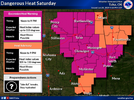
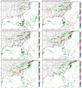
The couple of things you're concerned about will win out, persistence is the rule.Maybe the heat and lack of rain are getting to me but I'm all aboard. I'm concerned about a couple of things but we don't get those jet dynamics alot in the summer
-
Hello, please take a minute to check out our awesome content, contributed by the wonderful members of our community. We hope you'll add your own thoughts and opinions by making a free account!
You are using an out of date browser. It may not display this or other websites correctly.
You should upgrade or use an alternative browser.
You should upgrade or use an alternative browser.
Pattern June 2024
- Thread starter SD
- Start date
I'm joining team Shetley
JHS
Member
It might actually be going to rain here in a few minutes. We have a shower getting close to us now.
Edit: That shower got us and there are a couple of more showers popping up upstream of us. SE upslope flow doing its thing in the GSP county warning area now.
Edit: That shower got us and there are a couple of more showers popping up upstream of us. SE upslope flow doing its thing in the GSP county warning area now.
Last edited:
Idk man the hrrr over mixes the bl Sunday and still does thisThe couple of things you're concerned about will win out, persistence is the rule.
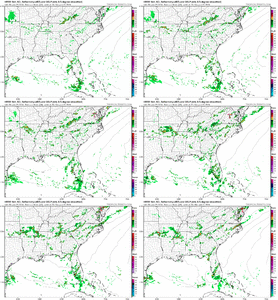
I'm still worried about what forms upstream Saturday afternoon that might kick an ofb or debris clouds into the area but if we can avoid that setup is looking better than 24 hrs ago
Last edited:
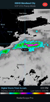
.5” tonight, future radar was right for a change.
Brent
Member
Seems to be the norm lately!Isn't summer greatView attachment 148184
Brent
Member
Seems to be the norm lately!
We haven't really been close to record highs but like again just like the last two summers the humidity is just awful
Yeah you're right I'm sure, you know more about this than I'll ever know. It's just, not to be that guy lol, last couple years it seems when a pattern/system/set-up/dynamics are right to produce xyz, more times than not they fail. Whether it's cold, snow, severe, rain, etc....if there's a fly that can get in the ointment, it does. I'm getting to be a pessimist in my old ageIdk man the hrrr over mixes the bl Sunday and still does this View attachment 148182
I'm still worried about what forms upstream Saturday afternoon that might kick an ofb or debris clouds into the area but if we can avoid that setup is looking better than 24 hrs ago
I understand I hope that I'm not convincing myself this is better than it is. If we miss tomorrow though this drought is going to hit the turbo button with dews in the 50s most of next week and highs near 100 by the 4th which gets a lot of places to basically 30 days with no rain. That's the usual point for a lot of turf grasses to go from dormancy to death and shallow rooted trees to start going. Not greatYeah you're right I'm sure, you know more about this than I'll ever know. It's just, not to be that guy lol, last couple years it seems when a pattern/system/set-up/dynamics are right to produce xyz, more times than not they fail. Whether it's cold, snow, severe, rain, etc....if there's a fly that can get in the ointment, it does. I'm getting to be a pessimist in my old age
I do not have access to the long range European model but the GFS has been persistent about the next good chance of rain being late next weekend into early the following week for Central North Carolina if we strike out again tomorrow. By then our area might as well be  . I'm
. I'm that we get some rain tomorrow.
Downeastnc
Member
I understand I hope that I'm not convincing myself this is better than it is. If we miss tomorrow though this drought is going to hit the turbo button with dews in the 50s most of next week and highs near 100 by the 4th which gets a lot of places to basically 30 days with no rain. That's the usual point for a lot of turf grasses to go from dormancy to death and shallow rooted trees to start going. Not great
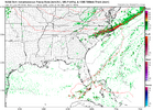
Add on the insane number if idiots that will still shoot fireworks in neighborhoods on the 4th even without rain, reckon the fire depts will be busy.....gotta hope the models are right with that line Monday morning, even then by the 4th it will be like it didnt even happen....that said I am seriously suspect of any image that looks like this at 6am....
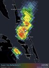
About to get our fourth heavy shower/storm of the day. With decent rains three out of four days; our dry spell is being hammered.
Starting to look like a 95 east event on the CAMs for tomorrow. Same story as the last few chances.
ENC is pleasant temperature wise. It’s borderline chilly here at the beach. Y’all don’t know what heat is. 75 Monday. Need to hoist a windchill warning
Downeastnc
Member
.43” today. I pulled up the monthly data today and realized why I’m not in the abnormally dry area. Turns out we got over 3 inches of rain earlier this month while I was in Maine so we are close to 4” for the month.
ABC11 in house model has zero up here tomorrow lol, what it shows is the scattered nature of storms. We really need a widespread soaker
JHS
Member
The 18z GFS is not good for most of us west of I-95 tomorrow.
After a great winter, it’s worth it!Isn't summer greatView attachment 148184
Under a level 2 threat for severe storms tomorrow. Hope we at least get some rain.
101 at RDU yesterday. 96 at the house my tempest must be too low
Or the reading at RDU might be too high as some people have been saying for a while now. At my house the temperature was 98 degrees yesterday.101 at RDU yesterday. 96 at the house my tempest must be too low
They'll break the all time record soon with that sensor and it will forever be in the record books. It should have an asterisk beside when they do101 at RDU yesterday. 96 at the house my tempest must be too low
Shaggy
Member
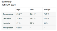
We are cooking this morning. Already 86 degrees with a HI of 95 at 8:40am
| Jun 30, 8:40 am | 86 | 75 | 70 | 95 |
Shaggy
Member
Broke 90 at 930am
Jun 30, 9:30 am90 73 59 98
Jun 30, 9:30 am90 73 59 98
88 with a dewpoint of 78 here. Just plain disgustingBroke 90 at 930am
Jun 30, 9:30 am90 73 59 98
Nerman
Member
We're baking again here and unfortunately missed all the pop-up showers the past few days.88 with a dewpoint of 78 here. Just plain disgusting
Downeastnc
Member
95 HI 111 love it.
If the storms hold off this will make a run at my all time record that I've recorded
If the storms hold off this will make a run at my all time record that I've recorded
Last edited:
Downeastnc
Member
We can't ask for much better than today if we fail it's just bad luck everything else is goodSame 95/77 heat index 110....gotta break down today at some point, some folks gonna get lucky....primed at the surface and plenty of water to work with just need something to keep them going when they pop.
View attachment 148208
View attachment 148209
BHS1975
Member
95 HI 111 love it.
If the storms hold off this will make a run at my all time record that I've recorded
RDU reporting 9 degrees higher air temp than others around it right now. They all are around 90.
Sent from my iPhone using Tapatalk
Rdu sensor + Sw wind =RDU reporting 9 degrees higher air temp than others around it right now. They all are around 90.
Sent from my iPhone using Tapatalk
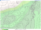
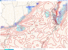
Same 95/77 heat index 110, hell heat index was 102 at 9 am....its all but gotta break down today at some point, some folks gonna get lucky....primed at the surface and plenty of water to work with just need something to keep them going when they pop.
View attachment 148208
View attachment 148209Coool Graphs. Love the precitable water
My Davis Vantage Vue just hit 93/80 with a HI of 114. Yikes!
Edit: Had a max HI so far today of 120 at 11:54 AM.
Edit: Had a max HI so far today of 120 at 11:54 AM.
Last edited:
Shaggy
Member
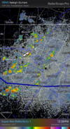
Nice explosion over the piedmont. Models suck for me this afternoon but I hope you guys strangle some frogs

