-
Hello, please take a minute to check out our awesome content, contributed by the wonderful members of our community. We hope you'll add your own thoughts and opinions by making a free account!
You are using an out of date browser. It may not display this or other websites correctly.
You should upgrade or use an alternative browser.
You should upgrade or use an alternative browser.
Pattern June 2024
- Thread starter SD
- Start date
Rates overcome allNot sure snow would stick to the roads tonight
Currently 88
- Joined
- Jan 23, 2021
- Messages
- 4,604
- Reaction score
- 15,202
- Location
- Lebanon Township, Durham County NC
I’m in Pasadena today where it’s about 85. Tomorrow we’ll be in Malibu and Santa Monica where it shouldn’t be much above 73ish.
I’m with yall in spirit though I swear
I’m with yall in spirit though I swear
BHS1975
Member
I’m in Pasadena today where it’s about 85. Tomorrow we’ll be in Malibu and Santa Monica where it shouldn’t be much above 73ish.
I’m with yall in spirit though I swear
There's plenty of heat waiting for you when you get back.
Sent from my iPhone using Tapatalk
Brent
Member
Well there is rain on radar here! Someone call the media
Another fail coming for Thursday locally. On to SundayThursday could be a huge rain day if we dont jump the prefrontal trough to the beaches with the ofb from the Wednesday night convection across the mid Atlantic.
It’s late June and we’re already in mid winter form
In all seriousness, it might never rain again
In all seriousness, it might never rain again
Shetley??It’s late June and we’re already in mid winter form
In all seriousness, it might never rain again View attachment 148134
Shaggy
Member
82/79 at 8am
You aren't wrongIt’s late June and we’re already in mid winter form
In all seriousness, it might never rain again View attachment 148134
Who knew that .5 would be too highI wouldn't be at all surprised to see less than .5 of rain the rest of June unless we find a way to pull that tropical thing this way. The pattern is just so meh
On top of this I think we could get a decent number of 100 degree readings coming too
Downeastnc
Member
its sad that the only maps that ever seem to verify IMBY are high temp and no rain maps....

GoDuke
Member
Stormsfury
Member
The 10am observations don't show much mixing.
Was able to squeeze out some storms around the area on Tuesday which brought...temporary relief ... don't see much in the way of mixing out today. Really bad when you're in flash drought conditions, have humidity ridiculously high and struggle to get appreciable rainfall.
National Weather Service Charleston SC
1000 AM EDT WED JUN 26 2024
NOTE: "fair" indicates few or no clouds below 12,000 feet with no
significant weather and/or obstructions to visibility.
Not all stations are quality controlled. Use data with caution,
especially dewpoint observations.
SCZ027-030-031-034>040-042>050-261500-
...Southeast South Carolina...
CITY SKY/WX TMP DP RH WIND PRES REMARKS
N Charleston MOSUNNY 88 79 74 S9 29.92F HX 103
Waterfront Prk N/A 84 78 82 S10 29.78F HX 95
Mount Pleasant MOSUNNY 86 82 89 S7 29.92F HX 105
Johns Island PTSUNNY 90 79 70 S7 29.93S HX 105
Pinopolis N/A 84 81 89 VRB3 N/A HX 98
Moncks Corner CLOUDY 86 79 79 SW9 29.92F HX 99
Summerville PTSUNNY 86 81 84 VRB7 29.91S HX 102
Beaufort MCAS PTSUNNY 90 79 70 S6 29.92F HX 106
Beaufort Arpt PTSUNNY 86 63 45 SW6 29.92S
Hilton Head Is CLOUDY 86 77 74 S9G16 29.93F HX 97
Walterboro MOSUNNY 86 79 79 SE8 29.93S HX 99
Allendale SUNNY 84 79 84 S5 29.91F HX 96
...Southern Midlands and Pee Dee...
CITY SKY/WX TMP DP RH WIND PRES REMARKS
Georgetown MOSUNNY 86 77 74 S7 29.93F HX 97
Kingstree MOSUNNY 86 73 66 SE7 29.92F HX 93
Orangeburg CLOUDY 83 78 85 S7 29.92F HX 93
Barnwell PTSUNNY 84 75 74 VRB6 29.92F HX 92
Aiken SUNNY 86 74 68 S6 29.93F HX 94
Manning MOSUNNY 82 77 83 SW7 29.92S HX 91
Columbia MOSUNNY 84 77 79 VRB3 29.90F HX 94
Sumter PTSUNNY 86 77 74 SE7 29.90S HX 97
Florence CLOUDY 83 77 82 S7 29.93F HX 92
Myrtle Beach MOSUNNY 86 81 85 S13 29.93F HX 102
N Myrtle Beach PTSUNNY 86 78 77 SW10 29.93F HX 98
$$
GAZ063-065-086>088-099>101-113>116-118-119-134>141-150-261500-
...Southeast Georgia...
CITY SKY/WX TMP DP RH WIND PRES REMARKS
Savannah Arpt MOSUNNY 86 77 74 S5 29.92F HX 97
Hunter AAF MOSUNNY 86 77 74 E6 29.89F HX 97
Fort Stewart MOSUNNY 84 76 77 SE6 29.88F HX 93
Statesboro SUNNY 88 73 62 S5 29.91S HX 95
Sylvania SUNNY 89 76 67 CALM 29.92S HX 100
Claxton SUNNY 90 71 54 CALM 29.91S HX 96
Millen SUNNY 89 71 56 SE5 29.91S HX 95
Metter SUNNY 91 74 57 SW3 29.90S HX 99
Reidsville SUNNY 90 73 56 CALM 29.91S HX 98
...CSRA, Central and far Southeast Georgia...
CITY SKY/WX TMP DP RH WIND PRES REMARKS
Thomson SUNNY 89 69 52 CALM 29.91F HX 93
Augusta-Bush MOSUNNY 82 75 79 CALM 29.89F
Augusta-Daniel SUNNY 85 73 67 SE3 29.92S HX 91
Swainsboro NOT AVBL
Vidalia SUNNY 91 70 49 CALM 29.91S HX 97
Eastman SUNNY 86 68 54 W3 29.94S
Hazlehurst MOSUNNY 89 72 55 CALM 29.91S HX 96
Alma SUNNY 86 76 71 S5 29.91F HX 96
Waycross MOSUNNY 89 80 75 W5 29.93S HX 105
Jesup SUNNY 88 77 70 CALM 29.95S HX 100
Baxley SUNNY 86 73 66 CALM 29.91S HX 93
Brunswick HAZE 87 77 72 S5 29.93F VSB 1/4 HX 98
Saint Simons MOSUNNY 86 81 84 S5 29.92F HX 102
Stormsfury
Member
Haven't checked the CAMs yet but this is super juiced at 11am...(except north central GA). Surface base CAPE.

Tiny chance of a brief shower tomorrow night in Athens. I'm betting we get 0.01" of rain if that.

Already 97 in Birmingham at 11 am. Ridiculous.
Man, these ensemble mean temperature maps... not looking good. We need to cash in with a tropical system.
 95 currently
  seems doable
100 at RDU lol...94 at the house with the DP nosediving. Going to pay for all this nice heat and drought this winter with lots of cold and snow.
Check this out for something fascinating at Augusta, GA (Bush):
-noon was 93 with a dewpoint of 76 on a SE wind at 9
-1PM was 99 with a dewpoint way down at 58 on a SW wind at 13 gusting to 22!!
That’s a heck of a boundary, a dry line of sorts that went through Augusta last hour! And it came in on SW winds!
@Stormsfury
-noon was 93 with a dewpoint of 76 on a SE wind at 9
-1PM was 99 with a dewpoint way down at 58 on a SW wind at 13 gusting to 22!!
That’s a heck of a boundary, a dry line of sorts that went through Augusta last hour! And it came in on SW winds!
@Stormsfury
Last edited:
Rdu is going to end up close to breaking the all time record
98.5 in Athens GA 
iGRXY
Member
The computer understands
Makeitsnow
Member
99 here on the truck temp off Milledge. Sickening but at least its a dry heat with dews in the upper 50s but that changes after today. Hopefully we can finally score though in the rain department. Everything is burned to a crisp.98.5 in Athens GA
Topped out at 97.3 with dews bouncing around the 60s all day.
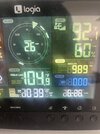
100.8 on the Tempest, maybe it's off but it's bone dry and my land is sandy soil, so it's believable to a degree
I was noticing that yesterday, at least it's relatively dry out. Fingers crossed on some rain tomorrow afternoon/night
we mixing down moist parcels here in richmond
99 over 68
99 over 68
100/63 in Chattanooga as of 3:15. Probably gonna end up maxing at 102.
Drizzle Snizzle
Member
Dewpoints are actually lower in Atlanta. However, it's cooler in Atlanta. I always thought lower dewpoints helps warm it up more.100/63 in Chattanooga as of 3:15. Probably gonna end up maxing at 102.
Here is the 6Z HRRR temperature map for 19Z (3PM EDT) tomorrow showing many non-mountain/non-coastal locations of VA/NC/SC/GA 101-104:
View attachment 148119
Here is the 6Z HRRR dewpoint map for the same hour showing the same locations with 43-58 dewpoints:
View attachment 148120
Comparing to NWS forecasts, these HRRR temperatures are several degrees hotter and dewpoints are significantly cooler. The HRRR dewpoints of 43-48 in the Charlotte, NC, to Macon/Columbus, GA, corridor look especially way too low. I’ll compare to reality tomorrow to see how well this HRRR run ends up verifying with temperatures/dewpoints in these 4 states’ non-mountain/non-coastal locations. I expect this run will verify with temperatures several degrees too hot most locations and dewpoints significantly too cool most locations.
The NWS, which wasn’t quite as hot and wasn’t nearly as dry vs HRRR, did better than the HRRR:
Verification of yesterday’s 6Z HRRR prog for temperature/dewpoint at 19Z/3PM EDT today:
Richmond, VA: HRRR 103/52 vs actual 99/68
Raleigh, NC: HRRR 100/61 vs actual 96/66
Charlotte, NC: HRRR 102/48 vs actual 98/63
Columbia, SC: HRRR 103/58 vs actual 100/60
Florence, SC: HRRR 99/64 vs actual 94/73
Atlanta, GA: HRRR 101/45 vs actual 95/55
Augusta, GA: HRRR 103/46 vs actual 99/52
Brunswick, GA: HRRR 96/66 vs actual 91/78
Summary for 8 cities:
-HRRR was too hot for all 8 with avg miss of +4.4 with range of +3 (Columbia) to +6 (Atlanta)
-HRRR was too dry for all 8 with avg dewpoint miss of -9.4 with range -2 (Columbia) to -16 (Richmond)
3PM data sources:
GA https://kamala.cod.edu/ga/latest.asus42.FFC.KFFC.html
SC https://kamala.cod.edu/sc/latest.asus42.CAE.KCAE.html
NC
RWR from KRAH
kamala.cod.edu
VA
RWR from KAKQ
kamala.cod.edu
#Winning

typically it's the other way around. all other things being equal in a hot, dry airmass like this, higher temps can mean a thicker thicker boundary layer and lower dews since drier air is getting mixed downDewpoints are actually lower in Atlanta. However, it's cooler in Atlanta. I always thought lower dewpoints helps warm it up more.
Downeastnc
Member
Come on sea breeze....

I can see it from the porch just need it to come another 20 miles

I can see it from the porch just need it to come another 20 miles
GoDuke
Member
Hottest I can remember in a while.
Looks like RDU hit 102 today. 
Somehow, we are 5+ degrees warmer than Fayetteville and Greensboro.
Somehow, we are 5+ degrees warmer than Fayetteville and Greensboro.
Makeitsnow
Member
Reached a high of 101.7 on my ws 2000..and confirmed by 2 other sensors. .but i haven't had much of any rain in weeks. Dry as a bone. Athens also got to 100.100.8 on the Tempest, maybe it's off but it's bone dry and my land is sandy soil, so it's believable to a degree
NBAcentel
Member
99F today In concord. As usual no rain
Actually 103Looks like RDU hit 102 today.
Somehow, we are 5+ degrees warmer than Fayetteville and Greensboro.