Another northern Wake County jackpot zone. 12 days in a row and counting.
-
Hello, please take a minute to check out our awesome content, contributed by the wonderful members of our community. We hope you'll add your own thoughts and opinions by making a free account!
You are using an out of date browser. It may not display this or other websites correctly.
You should upgrade or use an alternative browser.
You should upgrade or use an alternative browser.
Pattern July '22
- Thread starter Detective WX
- Start date
That’s been the jackpot zone past days but I think with the front moving south means a lot more people southward get involved here. See latest NAM for a general ideaIs it just me or have the storms this week just formed the shape of 540 and refused to come south untill after Raleigh?
Looks like a legit forcefield at times.
BHS1975
Member
They have always had more storms pop there. It's like a rain forest with all the trees.Another northern Wake County jackpot zone. 12 days in a row and counting.
Central/North..... This has been frustrating for me to see these storms continue to form just south of me (blue dot).Another northern Wake County jackpot zone. 12 days in a row and counting.

Only made it to 105*F at DFW (1 degree shy of the record high), due to a decent amount of mid-level clouds late morning / midday.
These storms are prolific rain makers, little cell moved over and dumped .99 in 30 mins
StormDrain
Member
Copped an absolute flogging yesterday, where I've had sustained 3-4"/hr rainfall rates from a slow-moving cluster of thunderstorms, of which, the ultimate precip total was 3.29" (83.6 mm) at my PWS yesterday.
Comfortably warm evening here, 88°F with a 78°F dew point @ my PWS as of 6 PM.
Comfortably warm evening here, 88°F with a 78°F dew point @ my PWS as of 6 PM.
LickWx
Member
some flash flooding issues here in Zebulon / lizard lick . Even little river is flooding around its banks a bit because of runoff

Solid >2.2” PWAT environment out ahead of this, when it comes down it will be heavy.
I’d want to be south of this line, evening is still early. Once mesoscale boundaries start colliding it could get a little more hit or miss.
Stoked.

I’d want to be south of this line, evening is still early. Once mesoscale boundaries start colliding it could get a little more hit or miss.
Stoked.
GarnerNC
Member
Has certainly filled in over past 30 minutes.

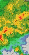
Not too shabby of a callIMO someone in this highlighted area are going to be seeing flash flood warnings later and someone inside there will see a significant amount of rainfall. Convergent boundary sliding southward already past VA border along with decaying MCS from yesterday moving over the mountains now with an attached meso low sliding with it generally to the East. Where these converge will squeeze out the immense amount of water the atmosphere is holding currently and cause big problems. Back building/ training all the sorts will cause problems .. I think more people “hit” today than usual but still more than likely there will be losers again. Hopefully whoever they are have already seen their fair share of water.View attachment 119840View attachment 119839

Shaggy
Member
Dumping
Bannerdude
Member

That dry creek behind the house/fence is not so dry anymore.
.01 .35 for the big wet. If anyone wants my admin position let me know. I quit
.gif")
Last edited:
1.53” so far, June total was 1.99 and going to be eclipsed.

.01 .35 for the big wet. If anyone wants my admin position let me know. I quit
View attachment 119853
The night is young? ?
Shaggy
Member
Flood advisory here
I got my half inch of rain. .52" so far. Folks to the south of me did a whole lot better; but beggars can't be choosy.
GarnerNC
Member
After all that, got a few minutes of light rain ?. Apparently you need to live in Knightdale or Wendell to get some.
.01 .35 for the big wet. If anyone wants my admin position let me know. I quit
View attachment 119853
Brutal.
.14 I rem many eps maps and efcwcmfm maps showing inches of rain lol
Oh sorry man! I feel you. If there is one person on here with worse luck than me it'd be you. I've had rain 4 days in a row until today and thought I was doing well. But I see everyone else's totals for the last week and realize my 1.6 inches in 4 days isn't all that great considering how the pattern is..01 .35 for the big wet. If anyone wants my admin position let me know. I quit
View attachment 119853
Shaggy
Member
Dumping again
LickWx
Member
I’m flooded here . Seeing 2-4 inches across this eastern wake area .
Just under 2” with more inbound, feeling confident of our June total with more. Stoked.

Oh now you wake up

Hit some terrible weather coming back through Charlotte around 5 o’clock this evening. Tons of wrecks and standstill traffic. Check out this structure around Salisbury..it was definitely rotating and my butt may have puckered a little bit
3.01” and counting, tapered off some but still going to add through the early night. Super pumped, missed what felt like since the start of this pattern shift, can’t wait to explore the rivers and streams once they settle back.
Shaggy
Member
iGRXY
Member
Storms finally firing up in WNC and the upstate. Let’s see if we can make it 5 straight days with rain.
3.25" and counting
5.24" month to date
Wow

5.24" month to date
Wow
@jackendrickwx the east side of Spartanburg looks to be doing well tonight!
JHS
Member
Up to 1.1 tonight with more possibly on the way. Much of Spartanburg county getting hit hard again.
This one threw down here earlier. That outflow was magical 
Sky86
Member
Raining, with thunder off in the distance

Yeah that should do it!


iGRXY
Member
Got sandwiched between 2 storms last night and picked up another 0.7” and we are currently raining now. Drought is really getting a dent put into it here
iGRXY
Member
At least in my backyard and from talking to people around Spartanburg and Cherokee counties, that rainfall estimation is always too low on totals so there likely was an even bigger dent put into the drought across most places