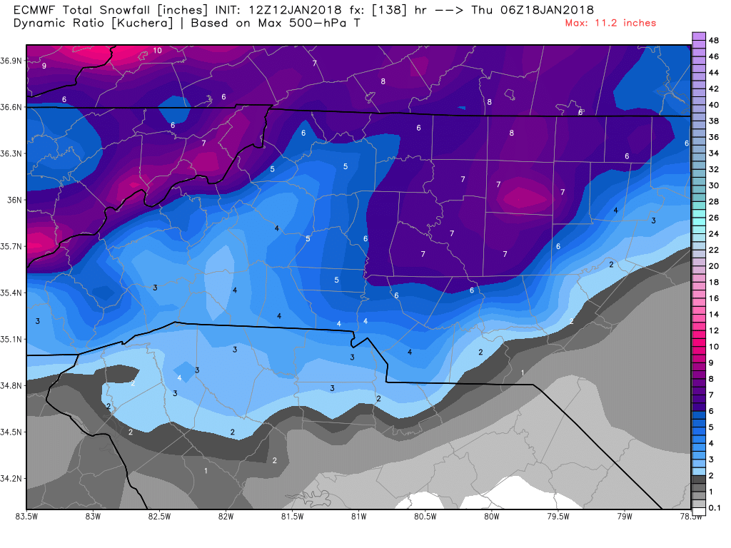
But if it forms further west, would that be better or worse for the Triangle?Here's the AFD from Raleigh:
Models are coming into better alignment Tuesday into Wednesday for
the H5 trough to develop a closed low anywhere from the Ohio Valley
to the MidAtlantic region. This scenario brings a much better
chance for higher QPF over central North Carolina with a
sufficiently cold airmass in place. For now, will introduce a chance
for snow Tuesday night into Wednesday. The further west the closed
low forms, the greater the possibility that precipitation east and
south of the Triangle will mix with or be all rain.
Could definitely put many of us in play. It depends on if the two portions of the storm would cooperate and keep the precip streaming from the gulf up through N GA and NW SC before developing the coastal for those on the east side. Some folks would surely be left out, but it could cover more area than the last 2 major storms this winter so far.board-wide event?
We actually don't know if the mix line wont cut thru Wake County, in fact in Feb 1984 it actually did... I just don't trust a setup with a weak overrunning frontal wave along an arctic front that never fully detaches from the northern stream and enters the contiguous US thru MI and WI until we get inside day 3. This is effectively cold air chasing moisture w/ an Anafront type frontal structure and hoping that the wave can advect enough moisture back on the other side of the front. We saw as recently as early December how fickle these frontal waves along arctic frontal zones can be...Well this is not like a typical scenario where the mix line is cutting through Wake County. Sure, I guess we could get the shaft yet again on the precip, but I'll take my chances with this setup if it verifies.
With any coastal, it depends on how far west. It's a balancing act to be strong enough and close enough to give you good precip but not too far to the west to mix. Way to early to fret about it. Just keep watching the trends over the next 48 hours and then we can hopefully dial it in and get the specifics.But if it forms further west, would that be better or worse for the Triangle?
Worse as there would be mixing issues... sound familiar?But if it forms further west, would that be better or worse for the Triangle?
Yeah, but right now sounds like RAH thinks that would be east and south of the Triangle. I wish the GFS solution would verify. That would be a great storm for a whole lot of folks.Worse as there would be mixing issues... sound familiar?
Sent from my SM-G920V using Tapatalk
It seems like a hybrid overunning setup and then the coastal enhancement? Also enhancement from an ULL? What could go wrong???While I agree that it is an anafrontal precipitation setup, I disagree with the cold air chasing moisture sentiment. The digging upper level trough that is being pinched by western U.S. and Atlantic ridging, is forcing it to turn neutral tilt, where southwesterly winds then overrun an Arctic frontal boundary, which develops a swath of moderate precipitation atop the Arctic air mass in place. As long as the trough can turn neutral tilt, precipitation is going to develop. While nowhere near a certainty at this point, models are certainly trending in that direction.
Anafronts are in general cold air chasing moisture setups, while we have an arctic airmass in place we still have to get here in time to catch the back end of the precipitation and/or hope that there's actually still precip here by the time the cold air arrives. There's not a lot of time or space for the wave to dig for us to get a prolonged, sustained southwesterly moisture fetch off the Gulf of Mexico with it diving in off Lake Superior and/or we don't know how strong or close the subsequent coastal low will be to advect moisture back across the boundary. I just wouldn't put a lot of stock into something like this until we're virtually inside 72 hours...While I agree that it is an anafrontal precipitation setup, I disagree with the cold air chasing moisture sentiment. The digging upper level trough that is being pinched by western U.S. and Atlantic ridging, is forcing it to turn neutral tilt, where southwesterly winds then overrun an Arctic frontal boundary, which develops a swath of moderate precipitation atop the Arctic air mass in place. As long as the trough can turn neutral tilt, precipitation is going to develop. While nowhere near a certainty at this point, models are certainly trending in that direction.
What needs to happen at H5 for the Central Midlands to get a good snowfall!! Jesus, we need it with no mesoscale problem!!
Tuesday for your areaSorry.guys but I'm lost in this thread. Been busy with today's storm . When is the time frame for this possible event
And also the top half of Alabama.Yeah, at this point, I'm hoping this winter could go down as the one in which (almost) every member got snow. We only have a few places in which it hasn't snowed at all, and that's central SC though the upstate, and then west into Texas and AR.
If we got ZR, it escaped me; never got below 33º until well after daybreak and from the time you could see, it was pure rain; at 500 was way too warm ... NWS reported no frozen, either ...Phil got a tiny bit of ZR but no SN or IP I think.