accu35
Member


Okay, I admit defeat. I better stop screaming dry air or that snow hole is going to verify. LOL. I think this could be a good storm, and maybe the one to fill in the holes that haven't had any yet.GFS goes BOOM!
GFS goes BOOM!

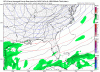
Wow, that's a nice large chunk with 3 to 6 inches for NC. No real sharp cutoff showing up.POW!


Even better! What a great look for NC. Lots of snow for lots of folks.I love it when the Kuchera ratio gives more than 10:1. BAM!
It gets even better and even big hit for coastal sections that just got the big one.... crazyI love it when the Kuchera ratio gives more than 10:1. BAM!

Well, "King of 500MB", it seems you have fallen from your throne. Thanks for the update Webber! It's weird to see such a model that did so well become such a laugh. It's bad though because we don't have any good LR models to trust now.The EPS is an utter joke after day 5-6 right now, checking the trend in 0z runs even against yesterday, the trough in the medium range which is associated w/ this threat for wintry weather has continued to strengthen as verification nears and is far cry from a massive ridge it was showing only 3 days ago for the same time frame. Give this another 2 days or so because the solutions even out to day 5 aren't particularly stable... Another ridge is showing up on the EPS at day 10, it probably won't verify either given there's a big ACWB event fixing to transpire over the Bering Sea & GOA coupled w/ a trough near Hawaii and north Atlantic blocking, all of which don't favor ridging along the eastern seaboard... At the very least if there is going to be a ridge here it will be transient at best
View attachment 2746
According to a met on other board , cold push is modeled to strong, and moisture would be rain se of ATL to CLTJust my weenie thinking i really think that the moisture will fill up on NGA and NAL better than GFS showed
I think my pessimism about dry air made it appear. I'm going to say that we could be sitting good if normal trends continue. BRING ON THE EURO!Just my weenie thinking i really think that the moisture will fill up on NGA and NAL better than GFS showed
If it’s better than zero it has to be better.Just my weenie thinking i really think that the moisture will fill up on NGA and NAL better than GFS showed
According to a met on other board , cold push is modeled to strong, and moisture would be rain se of ATL to CLT

ill go by the modelsAccording to a met on other board , cold push is modeled to strong, and moisture would be rain se of ATL to CLT
I highly doubt it's to warm for CLT.. but these trends are just starting so it's going to be a fun weekend of being glued to my computer hahaAccording to a met on other board , cold push is modeled to strong, and moisture would be rain se of ATL to CLT
Yep, right over my backyard!Love the hole over NGA in those clown maps