NoSnowATL
Member
22 here.
Same here19 coldest morning so far
Looks to be locked and loaded. Hopefully, everyone can cash in before the pattern breaks down.Eps was an endless buffet of west coast ridge and east coast trough love to see that the r2r changes weren't drastic
So a -38 degree anomaly would equate to roughly 5 below zero for Atlanta. I'm in!And not be outdone, the 0Z CFS also goes batshoot crazy late this month with extreme cold (overdone over snowcover but still would be idiotic cold) and a literally boardwide for southeasterners winter storm:
View attachment 104299
View attachment 104302
View attachment 104303
View attachment 104301
It does that from time to time but never verifies. The designers need to fix the model. Low of 27 at my house this morning. Keep those plants sleeping!So a -38 degree anomaly would equate to roughly 5 below zero for Atlanta. I'm in!


Very good news. Hopefully this means the last week of Janaury if the Models are correct,we might actually be tracking ether a true miller A low or a Southern Slider,instead of the miller A/B hyprid crap.All systems remain a go for a good shot at the coldest period of the winter to date during the last week of January. All models continue to suggest a good shot at the coldest period at least since the extreme cold of early January of 2018! Exciting times and what a turnaround from December! And Feb looks to start off cold, too, most likely. There still remains no indication that suggests a mild February.
Very good news. Hopefully this means the last week of Janaury if the Models are correct,we might actually be tracking ether a true miller A low or a Southern Slider,instead of the miller A/B hyprid crap.


The maps above are from the very cold 12Z GEFS for late month and here’s another to wet your appetite:
View attachment 104461
May this weekend prove to be a warning "shot across the bow" for a real board wide snowstorm in the next week or so.


I agree! That is exactly where I need to see it!Right where we want it
I'd prefer Jamaica. But I'll take itRight where we want it
And it’s wet! That’s amazeballsWeenietime again, folks. The 18Z CFS is the coldest run I’ve ever seen with an amazing 5+ BN for the rest of January and February for Atlanta! If this is true, this upcoming threat may be one of several. So, don’t sweat it.
The coldest 5 day period I’ve ever seen on a CFS run in the SE is this one, which has absolutely idiotic cold:
View attachment 104285
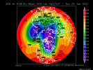
Look at the insane cross polar H5 for then:
View attachment 104286
Look at the plentiful qpf, which would be mainly wintry in the northern areas and probably include at least close calls to wintry pretty far south if this were to verify (I’m talking to you, @pcbjr , as well as to me):
View attachment 104287
Right where we want it


a little squash would actually be welcomed by a marginal few ...Here comes the extreme cold per 12Z EPS! Good chance for another cold high to follow this one per models by the way but that’s just speculation. Will the cold later interact in the SE with the subtropical jet??
View attachment 104526
View attachment 104528
For the best shot at a major SE winter storm, the best bet is if the Arctic high moves across the Ohio Valley so it doesn’t squash moisture too far south.
")


I swear you are always a good 5-6 degrees colder than me somehow ?Same here
We radiate well out here in the boonies...looks like I typically fall close to KTTAI swear you are always a good 5-6 degrees colder than me somehow ?
We radiate well out here in the boonies...looks like I typically fall close to KTTA
A mean high at freezing the furthest day out … what’s the spread look like


Holy cow and Thanks, Larry!Fantasy for especially @pcbjr from 12Z CFS but this is only 12 days out and the intense cold is just about unanimous on all of the models. So, anyway, here’s the perfect track for N FL snow with a low moving from the GOM to S FL while interacting with an extremely cold and large/sprawling high still centered way up over the N Plains (thus not squashing the moisture below the deepest SE):
View attachment 104557
View attachment 104558
This is a very rare mainly light accumulating snow for the gulf coast to south GA/SE SC and all the way down to Ocala, FL!! I mean a once a few decade rarity!
View attachment 104563
At 500 mb, there’s a moist WSW flow:
View attachment 104564
The 850’s are just below 0C to Ocala meaning this is pure snow:
View attachment 104568
Back to reality but this is far from an impossible dream.
Nah right around 6 ft. I have a Davis vantage vue and it was 20 this morning but it's around 10ft. I thought I had bad readings until I realized I was close to TTA that eased my concern about itIs your tempest right on the ground? I have mine about 9 foot up so was curious
Here's the spread some ridiculous cold members and warm in there.A mean high at freezing the furthest day out … what’s the spread look like
.png")