The reliable (cough cough) CFS is on board for a storm at day 10:

I guess we can add it to the list. The CMC yesterday, the GFS today and the Euro looked like it had a system with good 850s based on the free maps I saw. I'm guessing it didn't produce and was too far south since I didn't see a single map from it on here.The reliable (cough cough) CFS is on board for a storm at day 10:
View attachment 102766


Yeah I look at the number of members producing instead of a mean amount. I'd rather have half the members with something and a lower mean than have 2 or 3 hits and a higher mean that's skewed.starting to get a legit signal on the EPS, looking at individual members seem as if some of them have mixed precip (likely the ones that are lower) View attachment 102768View attachment 102769View attachment 102770View attachment 102771View attachment 102772

I agree. I’ve been too burned too many times the last few years with a solid mean. Give more members just showing something as I think that is a stronger storm signalYeah I look at the number of members producing instead of a mean amount. I'd rather have half the members with something and a lower mean than have 2 or 3 hits and a higher mean that's skewed.

Turns into a nice storm for NE
Oh that wasn’t what I was really showing that for, I’m liking that trend to a further south TPV, and us shoving that ridge more west which opens up options for us laterTurns into a nice storm for NE


Yea Boston going to get crushedTurns into a nice storm for NE
Oh that wasn’t what I was really showing that for, I’m liking that trend to a further south TPV, and us shoving that ridge more west which opens up options for us later
Oth this is really close for ENC and something that should be watched for those areasView attachment 102777View attachment 102778
with the nw trends we have seen it could really come into play for nc being 120hrs outOh that wasn’t what I was really showing that for, I’m liking that trend to a further south TPV, and us shoving that ridge more west which opens up options for us later
Oth this is really close for ENC and something that should be watched for those areasView attachment 102777View attachment 102778
Not really a ULL it’s a piece of the tropospheric polar vortex, I’d definitely want that further south and the cold it carriesSo the ULL moving further south to the lower latitues doesnt concern you?

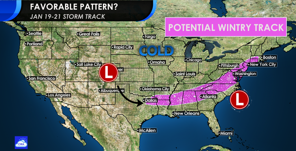
Congrats to the MA and NE! HECSView attachment 102779
That a accuweather graphic?


If we could just shift the general pattern west a bit… we get crushed

Yeah it's getting close now.Think wide right or a big NE hit is most likely given the overall setup but good griefIf we could just shift the general pattern west a bit… we get crushed
It’s always a step down process, with appetizers on the table we’re setting!Setting the table
Sent from my iPhone using Tapatalk
That’s why we should cheer for that bomb at hour 120 above. The Stronger that 50/50 it forms, the more it buckles and backs up the flow a bit to the west. That storm will probably miss us, but I’m still happy about it.If we could just shift the general pattern west a bit… we get crushed
No, click the Time to watch to go to the storyThat a accuweather graphic?

Considering how that storm a week ago trended at the last minute, we have at least 60 possible hours of big trendsView attachment 102784
Closely watching… 30 miles west and SEVA and NENC would have their most serious threat since January 2018. Obviously a lot of time for this situation to develop and change, but certainly is interesting to watch

We might go for it View attachment 102785
Why I said might, might happen might not, but it does look like you’ll be rightI doubt it. The trough to the west will likely shear it out.


Im happy the snowpack is building up there.. that will have good effects for us in the SE long term.
I want there to be as much snow pack as possible over the Mid-Atlantic and Northeast when when hit the 18th and our window opens. I want these high pressures moving over a refrigerator to help with our cold air feed