• Hello, please take a minute to check out our awesome content, contributed by the wonderful members of our community. We hope you'll add your own thoughts and opinions by making a free account!

Pattern Januworry

This is a good post.

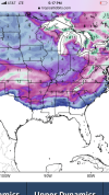
If you take a look at the 500 mb setup at 330, it looks pretty fantastic for a big winter storm. You have a nice -EPO that has driven cold air south out of Canada. It's trying to link up with the -NAO that has taken shape. You have a stretched out east-west PV that has allowed for confluence over the NE. The -NAO isn't ideal, but it is pretty stout and has slowed the flow down. The storm system in the Gulf is materializing and sliding east, and the nice big 1046ish Arctic high is sliding out of the Plains to the east....not diving due SE squashing everything. It's building in ahead of and in tandem with the southern storm. It is about as pretty of a setup as you want to see for a big SE and east coast widespread winter storm.

View attachment 102038

Run it out 12 hours later, and you can see things still look good. The arctic high has moved east toward the confluence zone, providing a strong cold air damming feed, and the Gulf low has slid eastward and is in the process of Miller B'ing/Miller A/B'ing.View attachment 102041

Now we go out to 360. The NAO block has weakened substantially, which has relaxed the confluence zone (where the ?? are) and allowed the high to slip NE out of a favorable position, which in turn allows the next shortwave to drop into the Lakes region, giving us everyone's favorite winter weather feature, the Lakes Low. Many of us have turned to rain.

Now, IF the model is too hasty with weakening the NAO (or even too weak to begin with), (and I suspect that if this were 48 hours out, it most certainly would be), then the high will stay anchored in place longer, and temps may be even colder. This would be a long duration big time winter storm.

View attachment 102042

I don't necessarily think we should latch onto this storm in particular. But if the pattern shapes up like the GFS is showing, then we will have plenty of things to watch coming up. I only went into detail here because there are so many pieces of the puzzle that are good or great here...and it's sometimes helpful to see how they all work together when the model is showing a resulting winter storm, like it is in this scenario.
As is this ... ?
 
f07607cc6bcc62bd942210128e5d6e5a.jpg


Sent from my iPhone using Tapatalk
This map sure does make it easy to figure out where CAE is... ??
 
Fwiw: The 12Z CFS takes away the +PNA-Aleutian low combo in late January as expected but it actually brings them back for most of early to mid February:

0CE78368-0A15-4B7D-A729-EFD2D3B94031.png

As a result, the bulk of the SE never warms to more than slightly warmer than normal for any length of time in late January/very early February before an overall slightly BN to NN regime returns (similar to now). In other words, the run shows nothing like the Dec torch returning over the next 6 weeks.
 
Gets squashed but I like the look, haven’t had that sort of look in a while, only problem might be some low pressure associated with northern stream coming out of Canada diving SE from the PNA ridge
I still like it. I've seen many times models underestimate the staying power of those southern stream impulses and the northern stream wind up further north. The wedge would still be the key player.
 
There’s several close calls on the GFS. Storms will come and go on future model runs in this pattern


Sent from my iPhone using Tapatalk
 
El Nino during La Nina? This looks fun. We need to find another 20 day model showing this.

See the next blob of blue expanding in the Pacific? - that's the next Pac jet extension to keep the party going

4d0y1QZ.gif
That trend to a -NAO (esp on the GEFS) is making this really fun to watch how this evolves as well
 
I’m liking this pattern, but I’m not believing anyone unless we get within day 10 after last year.
Feels like I'm beating a dead horse, but -------- this pattern around and just after mid-January is so fooking favorable for snow in the south. Can't believe I'm saying this, but this pattern is so good that I'll actually be legitimately surprised this time around if it doesn't snow at some pt in the Jan 15-25 period for a majority of this board, details obviously remain to be seen. On a scale of 1-10 in terms of favorability, this planetary-scale pattern is at least a 9.

Keep in mind the GEFS has had a very strong warm bias this winter in the medium-extended range and it's already showing 5-day averaged 850mb temp anomalies of up to -3 to -4C in parts of the south in the 11-16.

I mean... just wow lol.


View attachment 62425

View attachment 62424
This did not age well
 
Back
Top