Was that the storm when everybody got stranded on the interstates?
No, that was the month before.
Was that the storm when everybody got stranded on the interstates?
I think I may remember the 2nd one you are talking about now. It was mostly sleet and a little snow and ice up here. If I remember right this one did not even make it the Raleigh area and maybe barely into the triad. The system dried up as it came east. I'm not sure if ATL got anything from the Dec 2005 storm or not, but I know it got Athens GA pretty good.ATL area had two major icestorms in 2005. Then came February of 2014, which had major impacts for the southern half of ATL metro eastward to Augusta and Columbia. This storm killed the famous Eisenhower tree at Augusta National.
Yep not very much snow, 1-2 at most but at most but it shut down ATL and Birmingham.No, that was the month before.
I think I may remember the 2nd one you are talking about now. It was mostly sleet and a little snow and ice up here. If I remember right this one did not even make it the Raleigh area and maybe barely into the triad. The system dried up as it came east. I'm not sure if ATL got anything from the Dec 2005 storm or not, but I know it got Athens GA pretty good.
Yeah I had to leave my truck on the side of the road and walk in Bham.Yep not very much snow, 1-2 at most but at most but it shut down ATL and Birmingham.
That the one Chipper has to come rescue Freddy Freeman?Yep not very much snow, 1-2 at most but at most but it shut down ATL and Birmingham.
This may sound weird, but we have to work hard to earn a good winter storm in the SE. It's like trying to put together a team that can win the Super Bowl. I'm a Philadelphia Eagles fan even though I've lived in the Charlotte area almost all of my life. It took me 30 years of being a fan before I got to enjoy a Super Bowl win - makes it sweeter in the end

 Philly Fan here, too!

Dude!!! He’s one of them!!!!????. You didn’t know!Great to have you aboard kid. Newbie novices are always welcome. Stick around and maybe pick up some pointers from the experts here. We have LOTS of experts.

typically when models model ZR for the CAD areas, its marginal at best, and marginal 32 degree rains don't make for bad ice storms.Yea from anecdotal observation, it seems that most of the time CAD NC areas get saved from what could be considered crippling ice effects because precip type trends more IP than ZR as it gets closer to onset. That's why I don't get too concerned about heavy ZR until it's shown within 3 days or so.
Yea, wth was that move? a Miller Split? lolLots left to be desired at the end of the euro, but still lots of potential
Yeah gotta look at overall pattern and not specifics at this range and we got a whole lotta good pattern for something to shake out. Specifics right now are all noiseEuro is unimpressive to me. We start here:
View attachment 102028
That looks pretty good. An Aleutian low, nice PNA ridge, PV dropping out of Canada, etc.
Then, we get here:
View attachment 102029
Maybe some onset ice. But I don't really care the 500 mb pattern. Meh. Just one run though.
Stephen, I'm just a novice but this map here looks good overallWhy does the cold always retreat when the precipitation starts rolling in? What does it take to have cold move in and stay in place the entire duration of a storm without warming up?


I guess that's what I was trying to say. I don't care about specifics at 192 hours out. They're going to change anyway. But the actual evolution of the 500 mb pattern on the Euro does not support a widespread winter storm for the SE. I'd rather just toss everything after 120.Yeah gotta look at overall pattern and not specifics at this range and we got a whole lotta good pattern for something to shake out. Specifics right now are all noise
That's the time frame that interests me. I'm thinking sleet for my area at best case, though. I bet 850's will be marginal due to the trough placement. Good look for NC for sure!
This is a good post.Stephen, I'm just a novice but this map here looks good overall

The low is in an excellent place to give the SE a big storm (you want it along the Gulf coast or just off). The big 1040 HP over Minnesota is supplying the cold air. This snapshot makes it look like a classic storm is coming for the SE. The main problem I see with this is that the HP really needs to be anchored somehow; either with another HP (a blocking high, which would give you a "banana high") or with what is known as a 50/50 low (50 degrees N lat and W long) over the north Atlantic; it's counter-clockwise spin would help keep our high in place longer and more pressed. All this would help to keep the low from cutting like it does. We want it to track East over N Florida, or possibly curving towards Savannah.
Check out this next image
Here the H has moved way out and the L cut from Galveston to Indianapolis. The H strengthened to a 1043 and acts as a CAD high resulting in the ice storm, but that is NOT what we want. Also looks like the H moved way too fast (no anchor) and the L just cut behind it. Anchor that H over the Great Lakes and you got a big snowstorm.
Honestly that second image looks a little wonky to me. If the H is really moving that fast it makes sense it's clockwise spin is going to help push that L into a sharp cut, but the southern stream energy looks like it would be just as fast. That's how I see it but maybe I am way off; others, please correct me if I'm out to lunch.


When people say confluence, what are they referring too, or what are you drawing (beside the obvious um.) I'm too literal with the definition I guess.This is a good post.
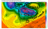
If you take a look at the 500 mb setup at 330, it looks pretty fantastic for a big winter storm. You have a nice -EPO that has driven cold air south out of Canada. It's trying to link up with the -NAO that has taken shape. You have a stretched out east-west PV that has allowed for confluence over the NE. The -NAO isn't ideal, but it is pretty stout and has slowed the flow down. The storm system in the Gulf is materializing and sliding east, and the nice big 1046ish Arctic high is sliding out of the Plains to the east....not diving due SE squashing everything. It's building in ahead of and in tandem with the southern storm. It is about as pretty of a setup as you want to see for a big SE and east coast widespread winter storm.
View attachment 102038
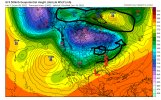
Run it out 12 hours later, and you can see things still look good. The arctic high has moved east toward the confluence zone, providing a strong cold air damming feed, and the Gulf low has slid eastward and is in the process of Miller B'ing/Miller A/B'ing.View attachment 102041
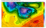
Now we go out to 360. The NAO block has weakened substantially, which has relaxed the confluence zone (where the ?? are) and allowed the high to slip NE out of a favorable position, which in turn allows the next shortwave to drop into the Lakes region, giving us everyone's favorite winter weather feature, the Lakes Low. Many of us have turned to rain.
Now, IF the model is too hasty with weakening the NAO (or even too weak to begin with), (and I suspect that if this were 48 hours out, it most certainly would be), then the high will stay anchored in place longer, and temps may be even colder. This would be a long duration big time winter storm.
View attachment 102042
I don't necessarily think we should latch onto this storm in particular. But if the pattern shapes up like the GFS is showing, then we will have plenty of things to watch coming up. I only went into detail here because there are so many pieces of the puzzle that are good or great here...and it's sometimes helpful to see how they all work together when the model is showing a resulting winter storm, like it is in this scenario.
Thank you for being in so much detail here, as it reinforces something that I mentioned earlier that there are so many pieces of energy and moving parts that models are going to have issues latching onto the right solution this far out… for example one thing that could be at play here is the progressive bias of the GFS in wanting to move things too quickly. As Brad P. often mentions, the first step in looking for potential winter weather is pattern recognition, and right now that’s the most important thing to look at.This is a good post.
If you take a look at the 500 mb setup at 330, it looks pretty fantastic for a big winter storm. You have a nice -EPO that has driven cold air south out of Canada. It's trying to link up with the -NAO that has taken shape. You have a stretched out east-west PV that has allowed for confluence over the NE. The -NAO isn't ideal, but it is pretty stout and has slowed the flow down. The storm system in the Gulf is materializing and sliding east, and the nice big 1046ish Arctic high is sliding out of the Plains to the east....not diving due SE squashing everything. It's building in ahead of and in tandem with the southern storm. It is about as pretty of a setup as you want to see for a big SE and east coast widespread winter storm.
View attachment 102038
Run it out 12 hours later, and you can see things still look good. The arctic high has moved east toward the confluence zone, providing a strong cold air damming feed, and the Gulf low has slid eastward and is in the process of Miller B'ing/Miller A/B'ing.View attachment 102041
Now we go out to 360. The NAO block has weakened substantially, which has relaxed the confluence zone (where the ?? are) and allowed the high to slip NE out of a favorable position, which in turn allows the next shortwave to drop into the Lakes region, giving us everyone's favorite winter weather feature, the Lakes Low. Many of us have turned to rain.
Now, IF the model is too hasty with weakening the NAO (or even too weak to begin with), (and I suspect that if this were 48 hours out, it most certainly would be), then the high will stay anchored in place longer, and temps may be even colder. This would be a long duration big time winter storm.
View attachment 102042
I don't necessarily think we should latch onto this storm in particular. But if the pattern shapes up like the GFS is showing, then we will have plenty of things to watch coming up. I only went into detail here because there are so many pieces of the puzzle that are good or great here...and it's sometimes helpful to see how they all work together when the model is showing a resulting winter storm, like it is in this scenario.
Good question...when you look at the height lines on the map, where I drew the arrows coming together, you see that the colors are getting closer together as you move toward the eastern tip of the PV.When people say confluence, what are they referring too, or what are you drawing (beside the obvious um.) I'm too literal with the definition I guess.
Can someone go further east with this map please?Where do I sign up for the 12z GFSView attachment 102044
Yep exactly. The thing about winter storms is that you need the little pieces to come together in the right way. The big pieces can help or hinder that process. The models can't really resolve the little pieces way out in time...heck they can't even do that really well in the short range. But you hope they can get the general bigger pieces somewhat right. That's what we look for out beyond D7.Thank you for being in so much detail here, as it reinforces something that I mentioned earlier that there are so many pieces of energy and moving parts that models are going to have issues latching onto the right solution this far out… for example one thing that could be at play here is the progressive bias of the GFS in wanting to move things too quickly. As Brad P. often mentions, the first step in looking for potential winter weather is pattern recognition, and right now that’s the most important thing to look at.
Can someone go further east with this map please?

Thx man, it sure looked better on the other map, lol
Sent from my iPhone using Tapatalk
Thx man, it sure looked better on the other map, lol
