Tsappfrog20
Member
Oh snap. 18z GEFS actually went west. Don’t usually see this ensemble abandon its op like that
Can you show them please!
Sent from my iPhone using Tapatalk
Oh snap. 18z GEFS actually went west. Don’t usually see this ensemble abandon its op like that


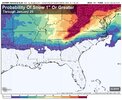
Absolutely. They have done a great job of programming into this model that mother nature does not allow snow in SC; outside of the occasional coastal; and that outputs should portray such. This at least shows where snow is possible and where it is not.It’s actually a really smart model to know exactly where there won’t be any snow. I’ll give it that. It’s really ahead of its time in many ways View attachment 182297
it was a no go.Does anybody have good news coming off the 18z Euro for system 1?
Oh well, on to 00z.it was a no go.
You listed two things that both sound terrible lol no storm for round 1 and little to no qpf for round 2. How do you still like where we stand with those 2 scenarios? Unless your fine with a possible dusting for round 2. Just curious.My two cents: for upstate, SC.
System 1: never been a real possibility and it’s completely dead at this point.
System 2 is most likely going to be a weakish band of precip. We’re gonna have better thermal profiles as a result, maybe good enough for snow north of i85. But we’re going to be fighting for qpf all week. Much more likely to lose this storm to no or little qpf then to lose it to heavy rain. As far a temps… we will be fighting for better cold out ahead of the storm, not for better caa as the storm moves through; that likely wont matter or come in to play, imo.
As such, I like where we sit right now. If we can hold on to a storm signal the next few days.
18z EPS however is different. Tick deeper and SWit was a no go.
A realistic outcome right now is a .2-.4 liquid event with 2-3 inches snow. That’s a very classic type of storm for us and wouldn’t shock me if that’s what we get here. That’s the hope for us, imo. Anything bigger is gonna be like 1/100 lottery odds.You listed two things that both sound terrible lol no storm for round 1 and little to no qpf for round 2. How do you still like where we stand with those 2 scenarios? Unless your fine with a possible dusting for round 2. Just curious.


If I had to guess on the dry members showing up. I would think the energy didn’t link up like it was on the earlier up. (Energy got left behind).18z euro ai mean cut way back on total for tn/nc because it has lots more dry members. But overall the foot print stayed the same if not shifted south and east a little.
This is not an awful spot to be in(if you’re in north ga/northern upstate sc).
View attachment 182309
where in the triad are you located?What about the Triad area in ur opinion
HPwhere in the triad are you located?

I'm good this week, at least through Saturday, per RNK. Cool and DRY! It's a brisk January night out there, 63 degrees... smh
All week and the Announcers today have said most of the game that the panthers shouldn’t even be here.Which is more emotionally draining? Model runs when it comes to snow in the south or Carolina Panthers football?
It's really almost about to drive me away from the love of chasing the elusive WINTER STORMS. It just stinks anymore. But I can't help it. What time does the 00z ICON start? I need help!!! lolHa we had a cold front to go back to average here. Back above normal Monday Tuesday... Wednesday.... Thursday... Friday... Now remember it's been above normal for a month straight basically
It's really almost about to drive me away from the love of chasing the elusive WINTER STORMS. It just stinks anymore. But I can't help it. What time does the 00z ICON start? I need help!!! lol
Definitely not like it was when we were growing up around here. Always saw snow. Sometimes for two daysIt's really almost about to drive me away from the love of chasing the elusive WINTER STORMS. It just stinks anymore. But I can't help it. What time does the 00z ICON start? I need help!!! lol
winston salem here


Yes. It also understands that a cold feed of high pressure to the north is “non negotiable” for Carolina snow. And that a maritime centered high in the western Atlantic actually works against you. AI is crazyThis alone is a major rework, not a tweak.
That’s what it told me aka not happening lol
Yea its balmy esp for early January! Will be windy and brisk seeing off at 0720 tomorrow. Hopefully dries it up a little.I'm good this week, at least through Saturday, per RNK. Cool and DRY! It's a brisk January night out there, 63 degrees... smh
i can name at least 4 winter storms here in the last 30 years that had no high pressure to the north. It does happen. And what’s being depicted next Saturday is how it can happen(but needs to remain weak).