trackersacker
Member
When the GFS and Icon are in lock step ….

Yeah when I seen GEFS 18z after this storm system today has passed through. Couldn't figure out if GEFS 18z was onto something or just being GFS 18z. But honestly, so far 0z runs have been interesting given they typical are the buzzkill runs.there's a lot of potential here. it reminds me a lot of the jan 4 2018 storm which had a lot of trepidation over digging, storm strength etc in the medium range before coming into form in the last 72 hours


GFS storm 1 and 2 combined total.
feel like we saw this look a few times last year. we did see some improvement but don't want to go through that again lolView attachment 182335
Yeah that’s definitely not going to work


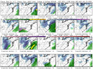
Very notable when you look at 500mb vort.GEFS making a prominent shift in kind with the op @hr84
Crazy that I went from “man this storm just don’t look cold enough” 36 hours ago to where we are nowGFS has sub zero temperatures in the mountains Friday morning with the snow cover up
there
View attachment 182337
I mean if you take a place like Birmingham AL off of this 00z GEFS, somewhere around 17/21 members are showing snow in the general vicinity which is quite an uptick from this morning.View attachment 182338
Even I’m getting little excited here
Don't mean to be the buzzkill here. But if euro doesn't end up at least trying to do this. Take GEFS with a huge grain of salt. I have seen countless times where GEFS shows something big then folds shortly after. IF EPS hops on the trend, specially watch 500mb vort trends, then yes I would absolutely keep an eye on this.View attachment 182338
Even I’m getting little excited here

Don't mean to be the buzzkill here. But if euro doesn't end up at least trying to do this. Take GEFS with a huge grain of salt. I have seen countless times where GEFS shows something big then folds shortly after. IF EPS hops on the trend, specially watch 500mb vort trends, then yes I would absolutely keep an eye on this.


Novelty sure, but I’m still intrigued by the potential. These negative tilted sharp troughs need just small adjustments for huge changes at the surface. Models also do a bad job of placing surface features for these storms in my opinion, and at the least, I am expecting a heavy mountain snow and nor’easter up the coast, but with an outside the mountains powerful deformation band potential if it digs a smidge more SW. I would feel more confident, obviously, if the Euro suite moved in a better direction soon.Seems like the threat for a novelty-minor event is going up here… if you keep slowing down and deepening, precipitation associated with the vort is more easily generated View attachment 182331View attachment 182332
View attachment 182341View attachment 182342
12z eps actually did have some members for both Huntsville and Birmingham that sniffed out some light snowfall like the 00z gefs/gfs just spit out. It’s obviously not much at all but it was a bit of a surprise. We can hope the 10-20% of those members double at 00z tonight, just saying.
Out of all the members there, the minority are the ones with rain over the southeast, most are cold and mostly dry or have a snow event. That would suggest warm air issued are not a problem for most, the bigger story will be moisture and how much of it, although I want to see more consistency on the ops as it still could be more of a mid south hit in the worst case for how north the rain/snow line could end up.Storm 2 still showing on the 0z gfs ENS tonight. Some are hits and some are surpress south. I’m not worried at this point.


If this is the trend moving forward (if it continues) we are gonna cook View attachment 182347


Really getting close to a whopper ULL setup. Dig it earlier and further SW and this becomes a bigger deal View attachment 182350