CNCsnwfan1210
Member
Good trend there and looking more like the EPS
Sent from my iPhone using Tapatalk


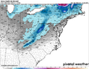
06z Gfs looks good for the 2nd system. Also gfs ai with great trends for system 2 as well.
View attachment 182391


Brother I really don't think we are done with this one. But yeh, I think we have some good times coming up. MJO looks to boat race into 8.Well, the threats are dwindling for my back yard for this week. Maybe the next time period of interest will turn out better? MJO should be more favorable by then.
View attachment 182400
@Mitch West we aren’t done yet!
.png")

What even is the next time period for us? I thought after the second threat it’s supposed to warm up again?Brother I really don't think we are done with this one. But yeh, I think we have some good times coming up. MJO looks to boat race into 8.View attachment 182401
Yep, might get into the 60s agan.What even is the next time period for us? I thought after the second threat it’s supposed to warm up again?
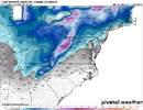
Unfortunately this has been a trend too, whether rain or snow.6z AI Euro is not looking good. We are trending to an east TN and mountains to DC threat. Still some boom potential with the ULL that’s always a bit of a wild card though.
View attachment 182392
The Euro showed a CAD event at the end of the run. Big ice storm for the CAD areas.What even is the next time period for us? I thought after the second threat it’s supposed to warm up again?
The rest of Winter.What even is the next time period for us? I thought after the second threat it’s supposed to warm up again?


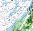
View attachment 182409
Here is where the 6z NAM ends off. Pretty bad at that point but then again it’s the NAM

540 line north of @LukeBarrette house and ripping fatties at my house. It’s aHeads up guys. End of January looking good. This is a classic Deep South snow lookView attachment 182408

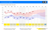
Well as bad as the NAM can be 2 things I've always thought it did fairly well: at H5 and picking up warm layers in winter events.View attachment 182409
Here is where the 6z NAM ends off. Pretty bad at that point but then again it’s the NAM

Those were the 6Z runs. 12Z is running now. And yes, I'm refreshing often, lol.Well as bad as the NAM can be 2 things I've always thought it did fairly well: at H5 and picking up warm layers in winter events. Not a good start to 12z suite but again it is LR NAM
Armpit of Hell brother. Normal activity in Columbia.Zebra stripe surface depiction for storm 2. Not sure I’ve seen this before View attachment 182411
not that it matters at this range, but gfs spitting that out from lack of saturation in the snow growth zone at that timestamp.Armpit of Hell brother. Normal activity in Columbia.
Yep, my bad. I didn't even look at time stamp or think about what time it was, duh! Lol thanksThose were the 6Z runs. 12Z is running now. And yes, I'm refreshing often, lol.
It’s very jumpy at H5 until 36 hours before the event. And yes it’s good with temps aloftWell as bad as the NAM can be 2 things I've always thought it did fairly well: at H5 and picking up warm layers in winter events.
And don’t forget the precip output is really underdone until about the last 24-30 hours where it and the 3k nam will align with other models.It’s very jumpy at H5 until 36 hours before the event. And yes it’s good with temps aloft
That's the 6 hour panel. You need to look at a 3 hour panel.Zebra stripe surface depiction for storm 2. Not sure I’ve seen this before View attachment 182411


 .
.It may fail in the end, but there is no doubt, fwiw, at this range, that the 12Z NAM is much improved from 6z. Deeper and further west. Let's see where it ends up. EDIT: Improved at the end, but the base of the trough never went negative tilt ,so too dry. View attachment 182418 .

View attachment 182419
Definitely improved from where 06z was