• Hello, please take a minute to check out our awesome content, contributed by the wonderful members of our community. We hope you'll add your own thoughts and opinions by making a free account!

Wintry January 8-9 Wintery Weather Potential!

hrrr at 4am tomorrow.
hrrr_ref_frzn_seus_21.png
 
Globals Lateste Run: GFS,New GFS,Euro,Canadian
Looking at Kucheras & 10:1, Canadian and New GFS beefiest. All of them sweet spot MTNS of Course, But all four Sweet spot I-40 in NC from Hickory/Old Fort to western Triangle area as you approach Durham/chapel Hill. That is a good marker along 40 as you leave the mtns and all models paint their heaviest along it. So right now between I40 from Old Fort to Durham and up to the NC line is the area with the highest potential outside mtns.

The Short Range Models which is what we should be foccusing on, espeacilly thermals as the day unfolds today. Paint the same area I just described with the most love. Heres the 6z nam and you can see this area gets a lot of love as well.
View attachment 63856

Looks like I just do make it in that line. Hope the short range models have a better handling on it now.
 
The Trend in noticing. For upstate folks basically that band will set up Greenville county North of 85 and east. I’ve noticed oconee and Pickens county either being a mix or rain. I suspect warm nose playing a role as well as heavier precipitation in that band Greenville east. Hope I’m wrong and oconee and Pickens gets a good inch or so as well but I could see the 1-2 maybe 3 inches favoring the eastern upstate more then the western upstate. Of course oconee and Pickens mountains should still do well because of elevation


Sent from my iPhone using Tapatalk
 
If the HRRR is correct, it will be a long day tomorrow for folks east of the Triad; watching the snow just hang over the western sections. Then finally (for what the 6z showed) the band would move eastward late in the day, giving eastern areas some accumulations, But definitely, the western areas would be the big winners.
 
If the HRRR is correct, it will be a long day tomorrow for folks east of the Triad; watching the snow just hang over the western sections. Then finally (for what the 6z showed) the band would move eastward late in the day, giving eastern areas some accumulations, But definitely, the western areas would be the big winners.

This would be brutal.

hrrr-carolinas-total_snow_kuchera-0150400.png
 
I’m very curious to see how the front end works out for central NC. There are some very distinct differences between the NAM and HRRR. The HRRR brings hours of heavy snow, while the NAM brings rain, or a dry slot before pulling the heavy backend.
 
Here was GSPs update as of 6:40am

.NEAR TERM /THROUGH FRIDAY/...
As of 640 AM: Water vapor imagery shows upper low centered near
Ark-La-Miss junction. Abundant cirrus are spreading downstream
within diffluent flow, between the low and a low-amplitude upper
ridge with its axis now over the CWA. Continued eastward movement
of the ridge axis should allow the cirrus to fill in across the
CWA as both features migrate eastward. This likely won`t occur
fast enough to keep today from being a fairly sunny day, if not
a tad cooler than yesterday.

Model consensus carries the surface low south of the I-20 corridor
late today through Friday morning, with the core of the upper
low moving near the southern border of TN and NC during this
timeframe. This will place most of the CWA just on the cool side
of the warm front. Most of the area will start off well above
freezing in the early evening; moisture will quickly deepen as
the sfc/upper low encroach on the area before midnight, bringing
in chances from the SW. The strongest dynamic forcing will precede
the upper low into the area, peaking in the predawn hours Friday,
with the better moisture lagging the forcing somewhat. The best
frontogenetic forcing will occur nearer the warm front. This is
reflected in QPF having trended slightly lower for the Piedmont. For
the higher terrain and Escarpment, however, now that more of
the hi-res guidance encompasses the event, QPF has increased in
response to the upslope flow occurring ahead of the low. Precip
type still looks quite tricky. There will be a lot of midlevel
dry air to overcome early in the event, and the WAA gives us a
weak warm nose as well (though not as strong as we often see with
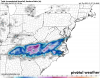
these sorts of systems). The higher mountains likely will see snow
through most of the event, but lower elevations and areas further
south will see some freezing rain and/or sleet where the warm nose
(along with evaporative cooling diminishing it at least locally)
is present. Our confidence has sufficiently increased on the
northern NC mountains and foothills meeting Winter Storm Warning
criteria from snow alone that a portion of the old Watch area has
been upgraded to Warning. Rabun County, Georgia is forecast to have
accumulations right at the split of advisory/warning, and with WFO
Peachtree City having decided to go Warning for their counties,
we upgraded Rabun to Warning for simplicity of messaging. The
remaining Watch areas will take longer to see accumulation reach
any criteria, and with the potential for accumulations to go one
way or the other, we have held off on upgrading there. These areas
almost certainly will need an Advisory or Warning depending on
where their final forecast total ends up.

With the upper low crossing the area during the day Friday, even as
winds turn more downslope and moisture becomes more shallow, there
will remain some support for precip across most of the area, but
particularly in the NC Piedmont. Temperatures will be held nearly
steady in the 30s where the precip is ongoing, and many areas
will continue to see snow during the day, possibly mixing with
rain. Strong lapse rates under the low may allow enhanced precip
rates and snow will be more likely during those periods. The event
will transition to northwest flow late Friday across the NC/TN
border area as PoPs continue to drop off east of there.
 
I’m very curious to see how the front end works out for central NC. There are some very distinct differences between the NAM and HRRR. The HRRR brings hours of heavy snow, while the NAM brings rain, or a dry slot before pulling the heavy backend.
Just looked at the latest 12z RAP and it is a little colder with 850s at hour 20 (compared to hour 21 at 11z). It only goes out to hour 21 (on Pivotal) but it looks like afterwards there would be wintery precip for a lot of central NC.
 
12NAM is going to be a big whooper for the Triad--initial thump, followed by mixing perhaps or dry slot, followed by back end.).
 
Snow changes over and hovers around the I85 corridor starting at 4 am. only 4 hours roughly of rain at the onset.
 
I enjoy the Facebook group. It’s a good group we got going over there. I encourage anyone in upstate sc ne Georgia and western nc to join.


Sent from my iPhone using Tapatalk
Thanks, we welcome everyone to join and post your maps and ideas for discussion.

 
12k NAM going with a nice front-end thump.
Packfan what are the exact or our closest Lat/Long you use for pulling up soundings? I usually try to creep south /east a shade to do mine, but I swear we are so right on top of transition line this time, trying to see sleet soundings etc . Thanks
 
Was disappointing to go from a Winter Storm Watch to nothing here in Pickens Co. GA but honestly was a little surprised to be in watch area to begin with after following model output and recent trends at this site. Simply put, remains a little too warm in my location.

Expecting nothing and getting a little something is better anyway.
Good luck to all of you who may see something a little substantial.

At least the pattern looks good moving forward!
 
Back
Top