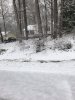
I’m not trying to say that soil temperatures are never important, but I do think sometimes we put too much weight on them. This pictures is taken from the streey In front of my house on 4/2/2019. We had 2.5 inches of snow accumulate that morning between 9-11am. This is what happened despite the previous 5 days having temperatures in the 60s with a late March and early April sun angle and the lowest the temperature got while the snow was falling was 33 degrees, so the soil temperature when this started was probably at least in the lower 50s. As of this morning soil temperatures in the NC Piedmont were mostly in the lower 40s and most areas will be below freezing the next couple nights. If a deform comes through on Friday like some models have suggested, soil temperatures won’t be an issue if the rates are there.
-
Hello, please take a minute to check out our awesome content, contributed by the wonderful members of our community. We hope you'll add your own thoughts and opinions by making a free account!
You are using an out of date browser. It may not display this or other websites correctly.
You should upgrade or use an alternative browser.
You should upgrade or use an alternative browser.
Wintry January 8-9 Wintery Weather Potential!
- Thread starter Ollie Williams
- Start date
-
- Tags
- winter
packfan98
Moderator
Looks like a trend today is the low slowing down and really cranking as it slowly moves out. As long as the upper level dynamics are there, there’s some decent BOOM potential from the deform band.
Tim Buckley's map:
NBAcentel
Member
Both the GFS/euro have the same idea and have a deform band over the Piedmont, if the NAM jumps on board we could have a boom situation as @packfan98 said 

when someone posts a snow map but I'm just a tad west and can't see my county...

Dewpoint Dan
Member
You had 2.5" accumulate but i bet if soil temps had been lower you would have had 5" !I’m not trying to say that soil temperatures are never important, but I do think sometimes we put too much weight on them. This pictures is taken from the streey In front of my house on 4/2/2019. We had 2.5 inches of snow accumulate that morning between 9-11am. This is what happened despite the previous 5 days having temperatures in the 60s with a late March and early April sun angle and the lowest the temperature got while the snow was falling was 33 degrees, so the soil temperature when this started was probably at least in the lower 50s. As of this morning soil temperatures in the NC Piedmont were mostly in the lower 40s and most areas will be below freezing the next couple nights. If a deform comes through on Friday like some models have suggested, soil temperatures won’t be an issue if the rates are there.
NBAcentel
Member
SoutheastRidgeYou had 2.5" accumulate but i bet if soil temps had been lower you would have had 5" !
packfan98
Moderator
Yeah, this is starting to get real. I still want all of the models and ensembles on board before I go crazy. There are still some that completely whiff.Both the GFS/euro have the same idea and have a deform band over the Piedmont, if the NAM jumps on board we could have a boom situation View attachment 63254View attachment 63255
Fountainguy97
Member
Both the GFS/euro have the same idea and have a deform band over the Piedmont, if the NAM jumps on board we could have a boom situation as @packfan98 said View attachment 63254View attachment 63255
man the difference in NE TN is just night and day. Onset is inside 3 days... geeze.
atleast the EURO is the aggressive one this time.
B
Brick Tamland
Guest
Yeah, this is starting to get real. I still want all of the models and ensembles on board before I go crazy. There are still some that completely whiff.
If this was the GFS and two days ago it would be a different story. But most of the runs have been better and better as we get closer, and the Euro showing this three days out is a big deal.
As a snowchaser, this thing is not consolidated at all. Highlands has been a good area in every run however.
Hi, I like to chase snow too, strongly agree there is limited amplification of H5-7 once it turns the corner. It’s a soft tilt at best vs late hard right hook.
Stephenb888
Member
Decided to come on see if I had lucked up into some snow this time around in Anderson SC. Nope still a big fat nothing.
Heelyes
Member
I know it's a clown map but it's still snowing right?
SimeonNC
Member
This is why I said earlier that for areas that will get the heaviest snow, that soil temps are irrelevant. Like seriously out of all the things to be worried about when it comes to this storm, soil temps aren't one of them.I’m not trying to say that soil temperatures are never important, but I do think sometimes we put too much weight on them. This pictures is taken from the streey In front of my house on 4/2/2019. We had 2.5 inches of snow accumulate that morning between 9-11am. This is what happened despite the previous 5 days having temperatures in the 60s with a late March and early April sun angle and the lowest the temperature got while the snow was falling was 33 degrees, so the soil temperature when this started was probably at least in the lower 50s. As of this morning soil temperatures in the NC Piedmont were mostly in the lower 40s and most areas will be below freezing the next couple nights. If a deform comes through on Friday like some models have suggested, soil temperatures won’t be an issue if the rates are there.
packfan98
Moderator
Now I’m all nervous about the 18z EPS. I guess I’m all in now. If we can get that solid deform band to produce, it’s much more favorable to getting a more uniform snow map and more folks will get in on the good stuff as the system moves out from west to east. Those hit or miss dynamic driven snow maps are not ideal unless you luck out.
NBAcentel
Member
Soil temps are overrated, what is not is a wet ground and marginal boundary layer conditions. Snow sticks a lot easier with surface below freezing, ideally <30, and a dry surface. Taking both in to account, it’s a garbage disposal for accumulations.
My concern is we find some way to orient the band west to east instead of more north south so the majority of us just watch a 30 mile wide band get pummeledNow I’m all nervous about the 18z EPS. I guess I’m all in now. If we can get that solid deform band to produce, it’s much more favorable to getting a more uniform snow map and more folks will get in on the good stuff as the system moves out from west to east. Those hit or miss dynamic driven snow maps are not ideal unless you luck out.
Not sure if anyone posted, but the control.
NBAcentel
Member
It’s not backing down

You should move to Roxboro! ?I'd feel really good if I lived along the NV/VA border rn.
I did, gets you 2-3. Bingo by definitionDon't take totals at face value. With diurnal heating, warm sfc, and soil temps, I would cut those totals into 1/3 or 1/2. More advisory totals.

Me and you can only go down hill from here lol. Euro jackpot under 70 hrs, nearing 1 foot. We are gonna get the "Mack Attack." Couple years ago, There was a storm jackpotting his back yard, double digits all the way to go time and he got warm nosed, hosed big time.Looks like a trend today is the low slowing down and really cranking as it slowly moves out. As long as the upper level dynamics are there, there’s some decent BOOM potential from the deform band.
Isn't Warning four inches and Advisory 1 inch?I did, gets you 2-3. Bingo by definition
SimeonNC
Member
I posted that January 2008 storm on the whamby thread as a nostalgia piece but I'm seriously starting to feel like this event will look similar to that totals wise.
Edit: East of the mountains I mean, the mountains should see a good snow.
Edit: East of the mountains I mean, the mountains should see a good snow.
3 plusIsn't Warning four inches and Advisory 1 inch?
I was thinking same thing. Youd think band would be oriented sw to ne curvature. Euro almost looked se to nw one frame above.My concern is we find some way to orient the band west to east instead of more north south so the majority of us just watch a 30 mile wide band get pummeled
Dont you usually see a deform band appear at a pivot point, then it follows storm ots, east, ne

This map says it's four.
View attachment 63279
| WINTER STORM WARNING VTEC: WS.W WMO: WWUS42 KRAH PIL: WSWRAH | Snow accumulations 3 inches or greater in 12 hours (4 inches or more in 24 hours); Freezing rain accumulations ¼ inch (6 mm) or greater; Sleet accumulations ½ inch (13 mm)or more. Issued when there is at least a 60% forecast confidence of any one of the three criteria being met. |
Ok Jimmy is riding the NAM. Crash my column please.Getting NAMed
Sent from my SM-N975U using Tapatalk
Yeah I mean it should and should really put a lot of locations in the game for at least some flakesI was thinking same thing. Youd think band would be oriented sw to ne curvature. Euro almost looked se to nw one frame above.
B
Brick Tamland
Guest
NAM just looks weird.
I was going off 3 Ollie. It could have changed , im old timer. Use to be 3 or .25 frzng rn. Not sure sleet.This map says it's four.
View attachment 63279
Edit. Sleet half inch. Thnxs sd.
Man sleet takes .5 qpf + to get to Half inch
NorthGaWinter4
Member
That’s the old run 18zGetting NAMed
Sent from my SM-N975U using Tapatalk
Thread.... I like the part about NE NC ?
If there is any sort of coastal transfer involved, then you can’t totally discount what the NAM is showing. I’ve seen these things nearly blank parts of the Carolinas in that type of situation.
It depends on the NWS field office definitions for specific areas. For example GSP issues a WSW for Charlotte metro if 2 inches in 6 hours or a storm total of 3 or more inches is forecasted. Obviously for areas further north and west the criteria is higherIsn't Warning four inches and Advisory 1 inch?
This map says it's four.
View attachment 63279
Great post and thank you, I’ve seen 12-18” in the Cascades over a 24hr period under advisory. 18”+ appears to be the threshold, WA state passes are likely close to 2’.