• Hello, please take a minute to check out our awesome content, contributed by the wonderful members of our community. We hope you'll add your own thoughts and opinions by making a free account!

Wintry January 8-9 Wintery Weather Potential!

RAH keeps hopes alive for really everybody in central NC:

Models and their ensembles are in good agreement with the track of
the system for the end of the week, however large differences exist
for the system early next week. Given the aforementioned pattern,
expect dry weather and near normal temperatures for Thursday, then
precipitation Thursday night through Friday night, dry weather for
the weekend, and then additional precipitation on Monday through
early Tuesday. Temperatures will range from the mid to upper 30s in
the northern Piedmont to the low 40s across southern central NC when
rain begins Thursday night, then as the profile cools a rain/snow
mix is expected across most of the Piedmont, with the best chances
of frozen precipitation north of the I-85 corridor. As the storm
exits the region Friday night, temperatures will lower enough for a
rain/snow mix across most of central
NC. Given the profile is so
close to freezing and surface temperatures will likely remain above
freezing, any small accumulations should be limited to elevated
surfaces. There is one possibility for higher snowfall accumulations
where banded snowfall develops or precipitation rates increase. This
could be enough for a few inches of snowfall to accumulate, however
this would be isolated and most areas that do see accumulations
should only have a tenth or two of snow
. Liquid precipitation totals
have slightly lowered with the latest forecast, with around one-half
inch expected near the SC border and one-quarter inch near the VA
border.
 
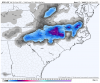
For a backside deform further NW, you want a icon like solution where it’s still not to unraveled, the NAM just a weaksauce af the whole time View attachment 63175View attachment 63176
That’s a good ULL track for the E TN/W NC mountains on the ICON, but not for central NC. We need that at least another hundred miles SW, I think.

EDIT: I mean SE!
 
Last edited:
That’s a good ULL track for the E TN/W NC mountains on the ICON, but not for central NC. We need that at least another hundred miles SW, I think.

EDIT: I mean SE!
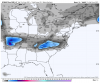
The icon tried at the last second to get something going along and east of 95. I don't think it's very different from the euro
 
let me get my umbrella ready
gfs_ref_frzn_seus_10.png
 
One of those setups where it’s going to be ripping fatties a couple hundred feet above your head. Might have to fly my drone up to get in on the action.
 
  • Like
Reactions: JJr
72 hours out and the models start going wonky, back and forth, trading solutions. Seems like this happens almost all the time with winter storm threats here.
 
Gfs favorable to NE upstate Nam favorable to NW upstate big differences


Sent from my iPhone using Tapatalk
 
Euro ENS and GFS18z at least seeeeeem to show consistency.
 

Attachments

  • Messages Image(4285952804).png
    Messages Image(4285952804).png
    338.8 KB · Views: 56
  • Messages Image(2180714286).png
    Messages Image(2180714286).png
    204.4 KB · Views: 56
Anyone putting stock in 10:1 snow maps is likely to be disappointed, Kuchera is the way to go, ratio driven and does an ok job accounting for changeovers. Gold standard is soundings and partial thickness plotted against p-type nomogram.
 
Big news station In Greensboro talk radio Ray Stageck calling for up to 4 inches Greensboro Friday. Last time I heard a wx man give a public accum forecast 75 hrs before an event was actually March 1993 and it was more than 4.

Track,Track,Track fellas and ITS Got to stay closed off. Dont sweat the new NAM out past 2 days.
 
GFS snow totals are crazy. They show what RAH has been discussing; whereas there will probably be bands that setup providing a lucky few with nice accumulations, but others close by very little. Just in Wake County it shows Wake Forest maybe getting 1" but Apex getting 8". This is going to be like summertime thunderstorms --> we will not know who scores until "go time".
 
I like the look of starting out as rain and changing over to snow. That way we don't have to worry about virga
 
Back
Top