Stormsfury
Member
I wonder what models they mets went with before the Jan 2000 storm.
ETA, AVN, NGM
I wonder what models they mets went with before the Jan 2000 storm.
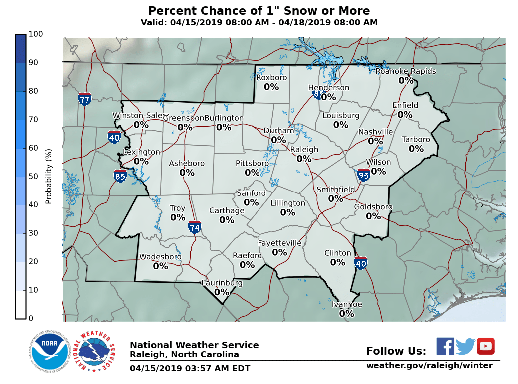
Is this good or bad for CAE?
The GFS is clearly shifting the qpf NW with each run. It may be slow but we're still nearly 2 days away from the event. If this slow but steady NW qpf shift were to continue over the next 6-7 runs, it will increase substantially on land considering how much closer the 1"+ qpf is getting. The NW qpf shift has averaged, say 20 miles/run. If that were to continue, that could still be another 140 miles NW shift. With it now being only 50-100 miles to the SE, a 140 mile NW shift would bring it onshore.
Lol that's total garbage you only have to go back to early December to realize that's not true and even after the models adjusted they were still wrong even near hour 0I think a pro met on the other board said that the OPs don't make significant shifts in the short range.
Come on, man. Look at where you are located on the maps and figure it out. You've been on weather boards for years I think.Is this good or bad for CAE?
The models usually do a piss poor job with handling the northwesterly extent and intensity of the precip shield in events like this so I'm not sure or very confident that we'll see a consistent shift SE over the next day or so, if anything more NW adjustments seem probable given everything at hand
I definitely agree they make NW adjustments in the precip field, but I just think the NAM is truly 'best case scenario'. Perhaps I just find it insanely hard to believe this storm will produce 12+ inch amounts deep in GA/SC and 20+ inch amounts in NC. I just think the RGEM is a good compromise between the NAM and globals give or take another 50 mile or so shift. If the RGEM trends towards the super amped NAM, then I'd put all my chips on the NAM.

Looks like B rad, is riding the GFS , lol! But he's also the one that 2 days before the big December storm, said no one in NC would see accumulating snow outside the mtns! Whoops!-------------Verified account @wxbrad 3m3 minutes ago
Here are my 1st thoughts on the Coastal storm Wednesday into Thursday. Very tight gradients for the snow to nothing along I-95 with ice closer to the coast mixed in.
He always does the same thing. Says no no no then dumps it on everyoneLooks like B rad, is riding the GFS , lol! But he's also the one that 2 days before the big December storm, said no one in NC would see accumulating snow outside the mtns! Whoops!
Yeah it's pretty obvious he's dry humping the global models... lolLooks like B rad, is riding the GFS , lol! But he's also the one that 2 days before the big December storm, said no one in NC would see accumulating snow outside the mtns! Whoops!
And the UKMET, and the Euro, and the CMC, and the, . . . shall I go on? Rule for snowfall in the SE: go with the warmest model and the one showing the least amount of snow.Looks like B rad, is riding the GFS , lol! But he's also the one that 2 days before the big December storm, said no one in NC would see accumulating snow outside the mtns! Whoops!

Sorry if it's already been mentioned but tropical tidbits now has a 2.5km hd rgem... unfortunately it cuts off majority of the southeast so no idea what it is doing downstream for those in NC. Also only goes out to 48hours.
Sent from my SM-N950U using Tapatalk


Don't y'all just love the weather. Lol.
***Ok kind of a longer post***
I for one don't think the trends are over yet at all, good or bad** it does concern me that the NAM (both 12km and 3km) virually has no support on how strong of a solution it's showing. Does it meannits wrong, no not all, but we know NAM loves to over do things as well. In fact it's usually awful at it. With that being said do I think it could be on to something absolutely. rgem will be a big help as well, but remember it still runs with a parent global, the CMC and can have a progressive bias as well. I really wish the euro had more support toward a NAM type solution to feel more comfortable about it. I will say the doc did trend toward the NAM a bit with more tilt and a slightly sooner phase there are 2 massive wild cards, IMHO here, 1. Where and when the phase happens (clearly the NAM is further west with that process then any other model) and 2. All the vorticity bombs/spikes/whatever in the western Atlantic. Those are going to force the SFC low out from the coast. So I expect them to trend less with time, yes. And I think that's been apparent with all models showing the SFC low closer to the coast.
In the end tonight's runs will be HUGE!! President Trump's HUGE voice. Lol will the NAM continue it's massive solution? (Both 12 and 3km) if it does then we might*** have a trendsetter OR if it starts to buckle and go toward the other models, well then I think we are in trouble for most outside coastal areas.
Map coming soon, no amounts yet to be honest.
Not until a little before 9pmWhen's the next NAM ing begin?


You in Raleigh or Fayetteville for this EricNot until a little before 9pm


The German model, while showing less than the NAM also puts the heaviest core of snow between I95 and US1 on the latest run over NC.


German has 8-12" here in the tidewaterThe German model, while showing less than the NAM also puts the heaviest core of snow between I95 and US1 on the latest run over NC.
Dang...what a difference. I'm with you as well, not buying into the NAM's solution yet either. That'd be quite a coup for it to pull that off, esp. with no other support really.To show you how far off the NAM is from the GEFS & EPS for the CAE area:
GEFS:
EPS:
If the NAM were to verify with it's 12/18z runs, it would be embarrassing to those two.
It's plain and simple.... It's too dry in the lower levels. There will be some snow in the Piedmont, but none of it will ever reach the ground unless those lower levels moisten up a lot. That's the problem.12k NAM is out in left field guys, if anything the 3km version looks plausible based on the surface reflections. I still can’t figure why the globals are not slinging more QPF inland given a bombing low off the Carolina’s. End result is the NAM will likely meet the GFS / ECMWF in the middle. If anything I feel less confident how this will play out than 24hrs ago. Moderate snow event for Florence to Norfolk, possiblility for a foot in NE NC and SE VA. Still expect to see a slight NW correction now that we are inside 48hrs, FAY to RWI should do very well.